Main Path
Akbel – Gelemiş (Patara Village)
(via northern path)
ID: 
27

Attractive section linking the villages of Akbel and Gelemiş (aka Patara Village), passing by the extremely impressive Delikkemer Roman aqueduct and finishing close to the excellent Patara ruins and its nearby beach.

Side view of Delikkemer.
Image credit:  
The Trekopedia Team
, All rights reserved

Essentials

Akbel (village)
Gelemiş (village)
Winding E–W section with Gelemiş to the W and Delikkemer roughly in the middle.
Mainly consists of gently rolling hills without any overly steep slopes, with an overall descent from E to W.
Follows a mix of hillside footpaths, walking on the aqueduct remains, and some rural roads through woodlands.
Way-finding is mostly good with signposts / painted blazes relatively frequent. There are a few junctions that can sometimes be problematic, though, so check your position against our GPS  tracks periodically.

Metrics

Select the tab below corresponding to the direction you plan to walk.
Towards Gelemiş:
Towards Akbel:
14.5 km / 9.0 mi
Distance
355 m / 1,165 ft
Ascent
595 m / 1,952 ft
Descent
~5.2 hrs
Duration
Elevation chart.
14.5 km / 9.0 mi
Distance
595 m / 1,952 ft
Ascent
355 m / 1,165 ft
Descent
~5.2 hrs
Duration
Elevation chart.

Handy Things to Know

The following notes are gathered from our own experiences and from feedback sent to us by other hikers. Let us know how we can improve these notes – and thanks!

Wayfinding

  • Sometimes way-finding can be a bit confusing close to Gelemiş. You should generally be able to figure out where to go , though.

Water

  • There’s no reliable water between the endpoints so top-up before departing.

Highlights

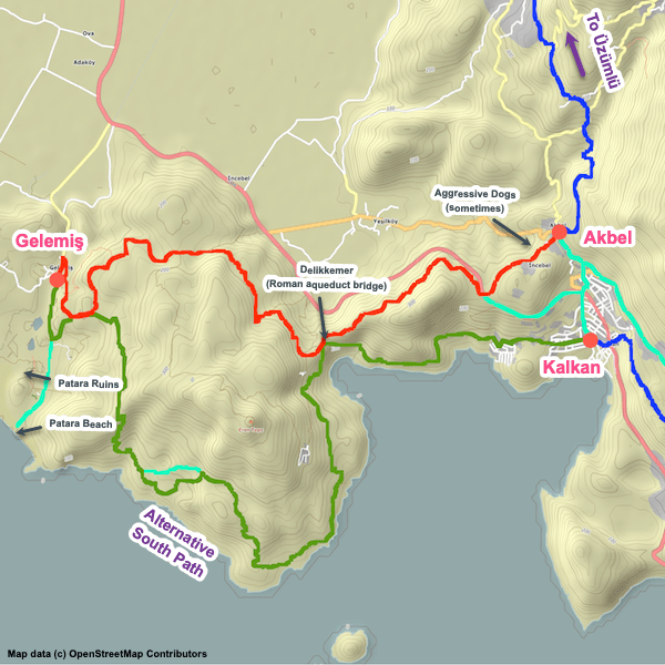
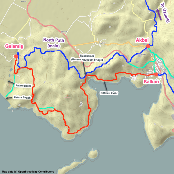
  • Delikkemer is very impressive and worth spending some time exploring.
  • Once at Gelemiş, set aside some time for exploration of the large Patara ruins site and maybe consider a swim at Patara’s excellent sandy beach.

Tips

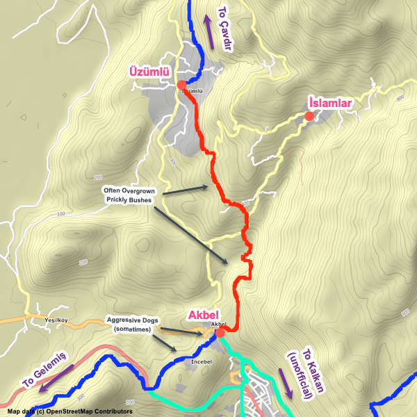
  • The trail passes a location where there tends to be a lot of bee houses. You’ll sometimes see the beekeepers there tending to them.
  • Much of the trail is lined with (and sometimes overgrown with) sharp plants – long pants are recommended.

Route Planning

  • The Lycian Way does a loop between Delikkemer and Gelemiş. This section follows the northern (inland) part of the loop. There’s also a section following the southern half of the route which stays closer to the coastline for much of its length.
  • Most people follow one part of the loop to Gelemiş and the other for the hike to Kalkan. However, some opt to follow the northern path both ways since it is shorter and easier. Some people also opt to hike to Gelemiş and then take a dolmuş / taxi or hitchhike to Kalkan.
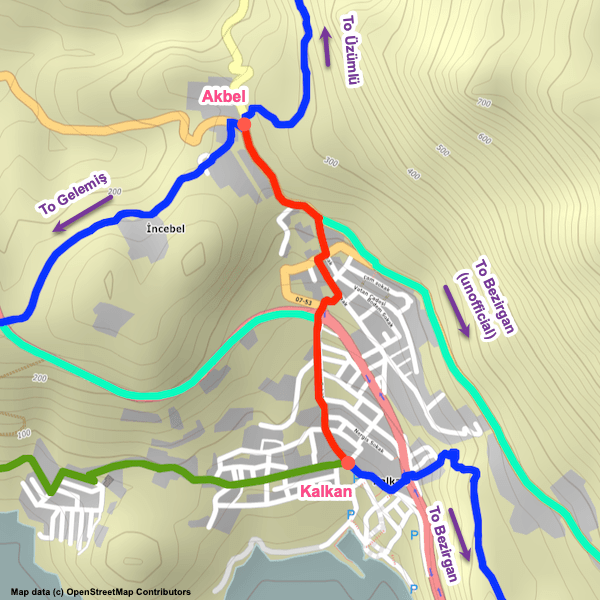
  • The loop could also be skipped entirely by going from Akbel to Delikkemer and then from Delikkemer directly to Kalkan. If you aren’t interested in Delikkemer, it is also possible to simply follow some local roads directly from Akbel to Kalkan.

Alerts / Hazards

  • We get a lot of reports of sometimes-aggressive dogs in the area in and to the immediate south of Akbel. Note that not all dogs in the area are aggressive – most are friendly ‘tag-along’ dogs who will join you for a while (often hours or even days in some cases) hoping for treats and seeking companionship. Alas, some dogs in this area definitely are aggressive. Biting incidents are rare but we have heard of at least one that happened in 2019 (minor injuries, but still…).
  • Stay alert to avoid stumbling on the uneven trail.

Camping

  • There are several good camping spots, including by the aqueduct.

Transport

  • Dolmuş service to Kalkan and other locations is available in Gelemiş though can be very limited during the off-season. If not available, hike (or hitchhike) out to D400 and wave down a dolmuş from there.

Attractions & Highlights

Notable highlights along the trail and at either endpoint include:
  • Delikkemer between Akbel & Gelemiş
    Historical Site
    Delikkemer (Roman Aqueduct)
    Between Akbel & Gelemiş
  • Lycian Ruins Near Gelemiş
    Historical Site
    Lycian Ruins Near Gelemiş
    Between Akbel & Gelemiş

Accommodations

Here’s what we’re currently tracking for this trail section:
  • Annotated map of Hotel Ince near Gelemiş
    Hotel
    Hotel Ince
    Near Gelemiş
  • Annotated map of Akay Pension in Gelemiş
    Guesthouse
    Akay Pension
    In Gelemiş
  • Annotated map of Ceyrek Camping & Bungalow in Gelemiş
    Commercial Campground
    Ceyrek Camping & Bungalow
    In Gelemiş
  • Annotated map of Golden Pension in Gelemiş
    Guesthouse
    Golden Pension
    In Gelemiş
  • Annotated map of Medusa Bar & Camping in Gelemiş
    Commercial Campground
    Medusa Bar & Camping
    In Gelemiş
  • Annotated map of Patara Flower Pension in Gelemiş
    Guesthouse
    Patara Flower Pension
    In Gelemiş
  • Annotated map of St. Nicholas Pension & Restaurant in Gelemiş
    Guesthouse
    St. Nicholas Pension & Restaurant
    In Gelemiş
  • Annotated map of Sulo Pansiyon in Gelemiş
    Guesthouse
    Sulo Pansiyon
    In Gelemiş

Wild Camping Locations

Here are the wild camping locations that we’re currently tracking along this trail section:
  • Campsite behind mosque in Akbel
    Wild Campsite
    Campsite Behind Mosque
    In Akbel
  • Campsite southwest of Akbel by D400
    Wild Campsite
    Campsite by D400
    Between Akbel & Delikkemer
  • Campsites by Delikkemer
    Wild Campsite
    Campsite by Delikkemer
    Between Akbel & Gelemiş
  • Campsite at Firnaz Koyu Near Delikkemer
    Wild Campsite
    Campsite at Firnaz Koyu
    Near Delikkemer
  • Campsite between Delikkemer and Gelemiş
    Wild Campsite
    Campsite
    Between Delikkemer and Gelemiş (north path)
  • Camping in field in Gelemiş
    Wild Campsite
    Campsite in Field
    In Gelemiş

Water Sources

Here are the water sources that we’re currently tracking along this trail section or at either endpoint:
  • Map of Water Fountain in Akbel [279] [CE2673]
    Water Source
    Water Fountain
    In Akbel
  • Water source between Delikkemer and Gelemiş (north path)
    Water Source
    Fountain
    Between Delikkemer and Gelemiş (north path)

Where to Next?

From Gelemiş:

  • Map showing the Lycian Way between Gelemiş and Kalkan via the southern path.
    Alternate Path
    Gelemiş – Kalkan
    Distance
    20.3 km / 12.6 mi
    Ascent
    860 m / 2822 ft
    Descent
    820 m / 2690 ft
    Est. Duration
    8.0
    This is the southern half of the loop between Gelemiş and Delikkemer, staying close to the coastline for much of its length, as well as the difficult but very attractive stretch between Delikkemer and Kalkan.

From Akbel:

  • Map showing the Lycian Way between Üzümlü and Akbel.
    Main Path
    Üzümlü – Akbel
    Distance
    5.9 km / 3.7 mi
    Ascent
    305 m / 1,001 ft
    Descent
    360 m / 1,181 ft
    Est. Duration
    2.6
    Section linking Üzümlü and Akbel and passing through the outskirts of İslamlar.
  • Map showing the Lycian Way between Akbel and Kalkan via an unofficial path along roads.
    Bypass Path
    Akbel – Kalkan
    Distance
    2.0 km / 1.2 mi
    Ascent
    0 m / 0 ft
    Descent
    200 m / 656 ft
    Est. Duration
    0.75
    Off-route (unofficial) shortcut along paved roads connecting Akbel to Kalkan. Useful if you are tight on time or simply want to cut the entire Gelemiş / Patara loop from your hike.

Pretty Pictures

Sometimes nothing beats a good photo. Or even a bad photo! If you’d like to share some or all of your photo collection with the Trekopedia community, contact us at photos@trekopedia.com and we can arrange a transfer of them. And thanks!
All photos are copyright by their respective owners and are used with permission.
  • Roman aqueduct.
    Delikkemer Roman aqueduct stretching across the valley
    Photo by 
    Anna Flack
     – 
    Sept 2022
  • Trail between Akbel and Delikkemer.
    Trail between Akbel & Delikkemer
    Photo by 
    The Trekopedia Team
  • Coastal view as seen from Delikkemer.
    Coastal view as seen from Delikkemer
    Photo by 
    Anna Flack
     – 
    Fall 2022
  • Building block of Delikkemer with trail blaze visible.
    Building block of Delikkemer with trail blaze visible
    Photo by 
    Anna Flack
     – 
    Fall 2022
  • Side view of Delikkemer.
    Side view of Delikkemer
    Photo by 
    The Trekopedia Team

How You Can Help

Trail research is never actually done. Here’s some of what we’re looking for:
✅   More photos! Ideally with geo-location information in the metadata. In addition to using some photos on Trekopedia, we add them to our internal reference database which significantly helps us with trail research. The more photos, the better! If you are willing to share your collection with us, we’d be incredibly grateful. Let us know and we’ll arrange a transfer.

✅   Points of interest. Help us identify (and geo-locate) accommodations, attractions, restaurants, markets, trail waypoints, confusing or problematic junctions, difficult or hazardous places, water sources, and so on. 

✅   Tips & recommendations. Share your thoughts with other hikers.
In addition to the above, please see this article for information on more general ways you can help. Thanks!
0 0 votes
Article Rating
Subscribe
Notify of
guest
1 Comment
Inline Feedbacks
View all comments
Trekopedia Team
Editor
Trekopedia Team
1 year ago

We’re told: “Path is a little overgrown in places” (between D400 and Delikkemer). Update: we’ve now had multiple confirmations in February and March of this section being somewhat overgrown, including with prickly bushes intruding on the trail (thus, wearing long pants and long-sleeve shirts is recommended).

1
0
Would love your thoughts, please comment.x
()
x