Main Path
Ovacık – Faralya
ID: 
10

Mountain section between the official Lycian Way start / finish point at the southern end of Ovacık and the village of Faralya on the opposite side of Babadağ (‘Father Mountain’).

Trail between Ovacık and Kirme.
Image credit:  
The Trekopedia Team
, All rights reserved

Essentials

Ovacık (town)
Faralya (village)
N–S section with the southern half arcing to the E. Ovacık is to the N. Most of this section is on Babadağ (‘Father Mountain’).
The northernmost 15%, near Ovacık, is relatively flat. The Ovacık side of the mountain is quite steep with a typical slope of about 18% and many stretches being 20%+. The middle of the section, where you’ll pass through the hamlet of Kozağaç and the village of Kirme, is a rolling plateau. The S side of the mountain is not quite as steep as the N side, with a typical slope of about 12.5%.
Most of the section is along sometimes-rocky but otherwise decent mountain footpaths. The endpoints are on roads / tracks as is the plateau in the middle.
Waymarkings are good. Look for both signposts and painted blazes on rocks.

Metrics

Select the tab below corresponding to the direction you plan to walk.
Towards Faralya:
Towards Ovacık:
12.8 km / 8.0 mi
Distance
765 m / 2,510
Ascent
735 m / 2,411 ft
Descent
~5.8 hrs
Duration
Elevation chart.
12.8 km / 8.0 mi
Distance
735 m / 2,411 ft
Ascent
765 m / 2,510
Descent
~5.8 hrs
Duration
Elevation chart.

Handy Things to Know

The following notes are gathered from our own experiences and from feedback sent to us by other hikers. Let us know how we can improve these notes – and thanks!

Water

  • Water is available at many locations, especially in and near to Kozağaç and Kirme.

Highlights

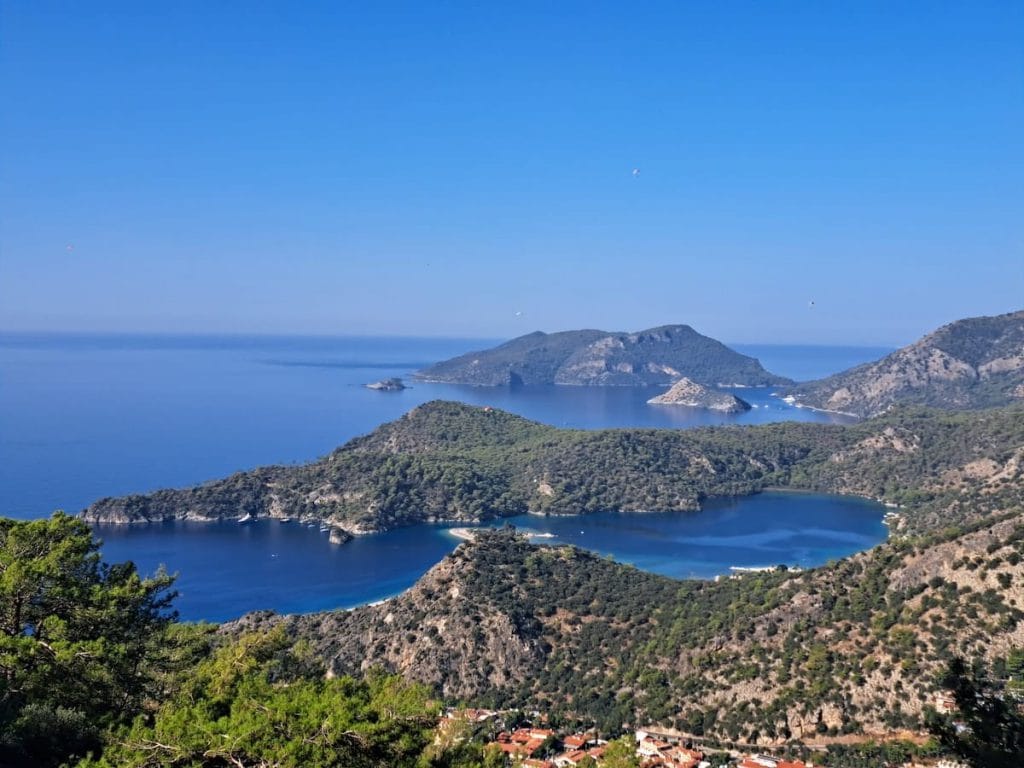
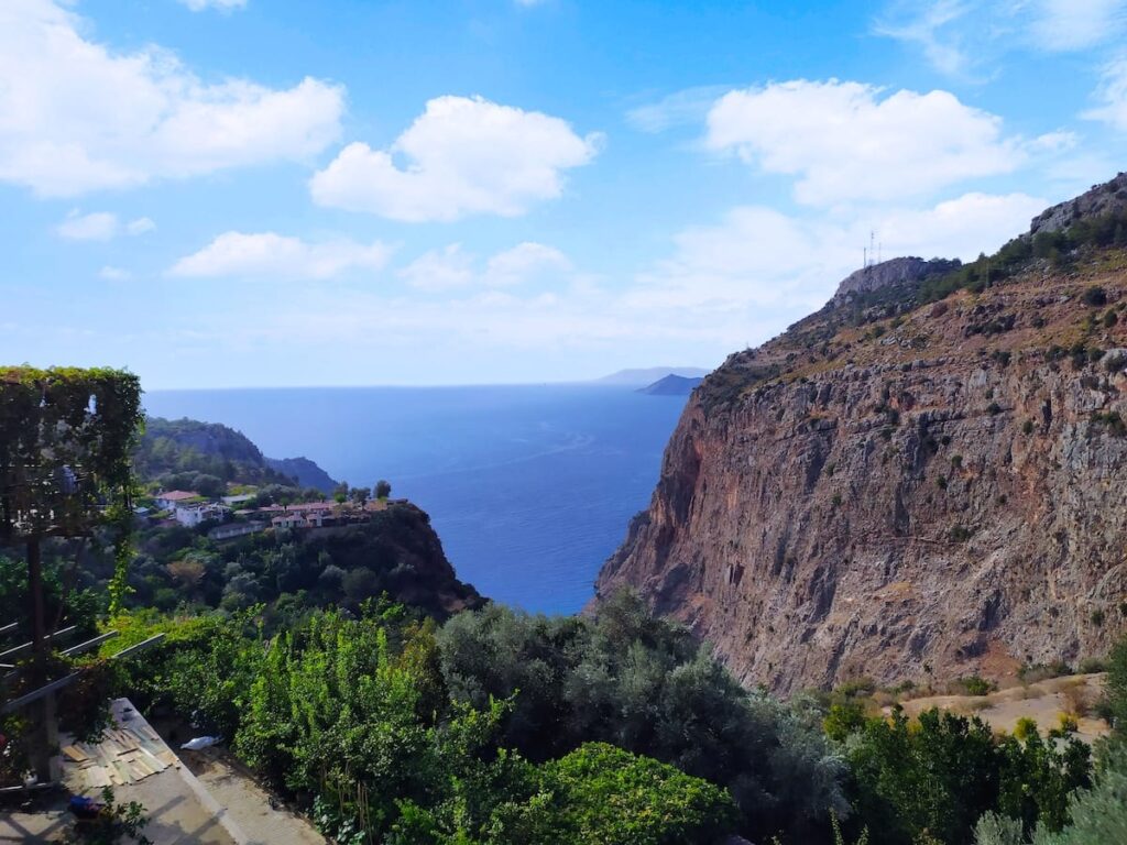
  • Beautiful section with fantastic views over the beach and lagoon of Ölüdeniz from the N slope and over Faralya / Butterfly Valley from the S slope. Don’t forgot to look back every now and then – the perspective changes frequently giving an entirely new look to the views.
  • On the N slope, don’t be surprised to see people paragliding above you as they descend from launching points on the mountain down to Ölüdeniz.
  • You’ll often spot turtles meandering along the trail with you.
  • At Faralya, Butterfly Valley offers some spectacular views (the village sits above the valley).

Tips

  • Sadly, you’ll often see a lot of garbage laying around the trail at the N end (in the areas that roads can reach), left behind by tourists driving to the viewpoints. Once on the mountain footpaths, the garbage largely disappears. Most of the Lycian Way is quite pristine other than sometimes garbage in some of the wells / cisterns.
  • There are lots of bee houses in the area. You’ll often find bees around water fountains / cisterns (they usually won’t bother you if you don’t bother them).

Route Planning

  • While this section is certainly not the hardest section of the Lycian Way, for those starting their walk in Ovacık it is a moderately challenging introduction. It probably won’t tax experienced hill walkers but others will get a decent workout. But it isn’t actually difficult. The rewards are amazing views, beautiful ever-changing terrain, and remote villages.
  • Some walkers do this section as well as Faralya – Kabak as part of the same stage.

Alerts / Hazards

  • Take caution in poor weather conditions, especially high winds.
  • Be aware that storms can come in very quickly atop the mountain, especially in spring. This applies to all mountains sections along the trail.
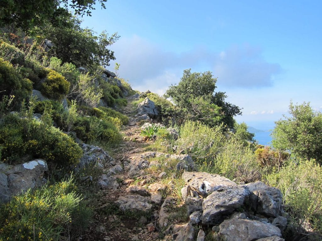
  • The path can be rocky / uneven in some places (though generally much better than most of the Lycian Way). Watch your footing. It is not unusual for a higher-than-normal number of people to twist an ankle on this section – not so much because of the trail itself as because those starting their walk in Ovacık simply haven’t acquired their ‘Lycian Way walking groove’ yet… It can take a couple of days to get used to the rocky, often uneven surface of most of the Lycian Way and to train yourself to automatically adjust your footing.

Accommodations

  • Lots of accommodation options on either endpoint (especially in Fethiye) but none that we are aware of between them (including in Kozağaç or Kirme).

Camping

  • Wild camping spots are available near Kozağaç / Kirme and in some places along the S slope. Along most of the N slope, though, it is too steep and rugged for camping.

Amenities

  • Fethiye has a full range of amenities, including camping / outdoor gear.
  • There’s a market in Kirme with a modest selection.
  • A couple of cafés are available in Kirme.
  • Meals / beverages are available in Faralya at the various guesthouses (generally even to non-guests).
  • There are toilets (and water) at the mosques in Kozağaç and Kirme.

Transport

  • Dolmuş service is available in Faralya from a stop at the north end of the village, across from Gül Pansiyon.
  • Fethiye is a transport hub, both for local dolmuş service along the coastline as well as coach service to / from the rest of Turkey.

Attractions & Highlights

Notable highlights along the trail and at either endpoint include:
  • Butterfly Valley by Faralya
    Landscape
    Butterfly Valley
    By Faralya

Accommodations

Here’s what we’re currently tracking for this trail section:
  • Annotated map of Ölüdeniz Hostel & Suites in Ovacık
    Hostel
    Ölüdeniz Hostel & Suites
    In Ovacık
  • Annotated map of Everest Lodge in Ovacık
    Hotel
    Everest Lodge
    In Ovacık
  • Annotated map of Montana Pine Resort in Ovacik
    Hotel
    Montana Pine Resort
    In Ovacik
  • Annotated map of Onur Motel in Faralya
    Hotel
    Onur Motel
    In Faralya
  • Annotated map of Melisa Pansiyon in Faralya
    Guesthouse
    Melisa Pansiyon
    In Faralya
  • Annotated map of Gül Pension in Faralya
    Guesthouse
    Gül Pension
    In Faralya
  • Annotated map of Montenegro Motel & Restaurant in Faralya
    Guesthouse
    Montenegro Motel & Restaurant
    In Faralya
  • Annotated map of Faralya Limon Hotel in Faralya
    Hotel
    Faralya Limon Hotel
    In Faralya
  • Annotated map of Faralya Misafir Evi in Faralya
    Guesthouse
    Faralya Misafir Evi
    In Faralya
  • Annotated map of Keyif Motel in Faralya
    Hotel
    Keyif Motel
    In Faralya

Wild Camping Locations

Here are the wild camping locations that we’re currently tracking along this trail section:
  • Campsite between Ovacık & Kozağaç
    Wild Campsite
    Campsite
    Between Ovacık & Kozağaç
  • Map of Camping Spot between Kirme & Faralya [724] [CE1581]
    Wild Campsite
    Camping Spot
    Between Kirme & Faralya
  • Annotated map of wild camping spot between Kirme & Faralya [725] [CE2503]
    Wild Campsite
    Camping Spot
    Between Kirme & Faralya

Water Sources

Here are the water sources that we’re currently tracking along this trail section or at either endpoint:
  • Map of Cistern between Ovacık & Kozağaç [755] [CE1625]
    Water Source
    Cistern
    Between Ovacık & Kozağaç
  • Cistern between Ovacık & Kozağaç
    Water Source
    Cistern
    Between Ovacık & Kozağaç
  • Cistern between Ovacık & Kozağaç
    Water Source
    Cistern
    Between Ovacık & Kozağaç
  • Fountain at mosque in Kozağaç
    Water Source
    Fountain at Mosque
    In Kozağaç
  • Map showing Fountain in Kozağaç [756] [CE625]
    Water Source
    Fountain
    In Kozağaç
  • Spigot with basin between Kozağaç and Kirme
    Water Source
    Spigot with Basin
    Between Kozağaç and Kirme
  • Spigot with basin between Kozağaç and Kirme
    Water Source
    Spigot with Basin
    Between Kozağaç and Kirme
  • Fountain at northern edge of Kirme
    Water Source
    Fountain
    At Northern Edge of Kirme
  • Map showing Fountain in Kirme [757] [CE631]
    Water Source
    Fountain
    In Kirme
  • Fountain in Kirme
    Water Source
    Fountain
    In Kirme
  • Map of Water Fountain Between Kirme & Faralya [326] [CE634]
    Water Source
    Water Fountain
    Between Kirme & Faralya
  • Map of Water Fountain Between Kirme & Faralya [327] [CE635]
    Water Source
    Water Fountain
    Between Kirme & Faralya

Where to Next?

From Faralya:

  • Map showing the Lycian Way between Faralya and Kabak.
    Main Path
    Faralya – Kabak
    Distance
    4.8 km / 3.0 mi
    Ascent
    280 m / 919 ft
    Descent
    355 m / 1,165 ft
    Est. Duration
    2.3
    Enjoyable hilly, forested section with some nice views. There are lots of accommodation options at both ends of this section plus some camping spots along the way.
  • Map showing the unofficial coast route between Faralya and Kabak Beach.
    Alternate Path
    Faralya – Kabak Beach
    Distance
    9.8 km / 6.1 mi
    Ascent
    560 m / 1,837 ft
    Descent
    880 m / 2,887 ft
    Est. Duration
    5.0
    Follows an attractive coastal path between Faralya and Kabak Beach. Not officially part of the Lycian Way but an increasingly popular option nevertheless.

From Ovacık:

  • Map showing Lycian Way between Kayaköy and Ovacık.
    Main Path (Extended Trail)
    Kayaköy – Ovacık
    Distance
    5.5 km / 3.4 mi
    Ascent
    360 m / 1,181 ft
    Descent
    220 m / 722 ft
    Est. Duration
    2.5
    This is the direct option between Kayaköy and the official Lycian Way start / finish point in Ovacık, typically part of a single stage between Fethiye and Ovacık.
  • Map showing the Lycian Way between Ölüdeniz and Ovacık.
    Unofficial Alternative
    Ölüdeniz – Ovacık
    Distance
    2.8 km / 1.7 mi
    Ascent
    300 m / 984 ft
    Descent
    8 m / 26 ft
    Est. Duration
    1.2
    Unappealing connector section between Ölüdeniz and the Lycian Way’s official start / finish point at the edge of Ovacık. Entirely alongside a busy, steep road. Many people just take a dolmuş.

Pretty Pictures

Sometimes nothing beats a good photo. Or even a bad photo! If you’d like to share some or all of your photo collection with the Trekopedia community, contact us at photos@trekopedia.com and we can arrange a transfer of them. And thanks!
All photos are copyright by their respective owners and are used with permission.
  • Cliff Face of Father Mountain in the Clouds (shorn cliff by Kozağaç).
    Cliff face of Babadağ (‘Father Mountain’), enveloped in wispy clouds, near Kozağaç
    Photo by 
    The Trekopedia Team
  • Trail between Ovacık and Kirme.
    Trail between Ovacık and Kirme
    Photo by 
    The Trekopedia Team
  • Official Lycian Way endpoint in Ovacık
    Official Lycian Way western endpoint
    Photo by 
    Darren Moens
     – 
    Fall 2022
  • Sloping footpath on ascent from Ovacık
    Sloping footpath on ascent from Ovacık
    Photo by 
    Darren Moens
     – 
    Fall 2022
  • Signboard for Lemon Café in Kirme
    Signboard for Lemon Café in Kirme
    Photo by 
    Darren Moens
     – 
    Fall 2022
  • Mosque in Kirme
    Mosque in Kirme
    Photo by 
    Darren Moens
     – 
    Fall 2022
  • View over beach at Ölüdeniz
    View over beach at Ölüdeniz
    Photo by 
    The Trekopedia Team
  • Coastal view on ascent from Ovacik
    Coastal view on ascent from Ovacık
    Photo by 
    Darren Moens
     – 
    Fall 2022
  • Trail between Ovacık and Kirme.
    Trail surface between Ovacık and Kirme
    Photo by 
    The Trekopedia Team
  • View from near Kozağaç
    View from near Kozağaç
    Photo by 
    The Trekopedia Team
  • Rock Field From Earthquake near Kozağaç
    Rock field from earthquake near Kozağaç
    Photo by 
    Stu Hackett
     – 
    Spring 2016
  • Looking towards Butterfly valley.
    Looking towards Butterfly valley
    Photo by 
    Łukasz Ostojski
     – 
    Fall 2021

How You Can Help

Trail research is never actually done. Here’s some of what we’re looking for:

In addition to the usual items listed below, we’re specifically interested in details on more potential campsites along this section. Thanks!

✅   More photos! Ideally with geo-location information in the metadata. In addition to using some photos on Trekopedia, we add them to our internal reference database which significantly helps us with trail research. The more photos, the better! If you are willing to share your collection with us, we’d be incredibly grateful. Let us know and we’ll arrange a transfer.

✅   Points of interest. Help us identify (and geo-locate) accommodations, attractions, restaurants, markets, trail waypoints, confusing or problematic junctions, difficult or hazardous places, water sources, and so on. 

✅   Tips & recommendations. Share your thoughts with other hikers.
In addition to the above, please see this article for information on more general ways you can help. Thanks!
0 0 votes
Article Rating
Subscribe
Notify of
guest
0 Comments
Inline Feedbacks
View all comments
0
Would love your thoughts, please comment.x
()
x