

Notes:
– Each section below is one of three types: Main (official trail, way-marked), Alternate (an official, way-marked path that can be taken instead of a Main one), and Unofficial (popular and/or convenient options that are not part of the official Lycian Way; these may or may not be way-marked). The distinction between ‘Main’ and ‘Alternate’ is something we do ourselves; the trail maintenance people don’t typically distinguish the variants in this way.
– Sections are listed roughly in ‘route order’ as they’d be encountered walking eastward
– Use the sidebar menu to jump to a specific region.
– Tap / click on a section to open a details page for that section.
– Please let us know how we can make this listing more helpful for you.
Region 01: Fethiye – Letoon
The sections in this region connect the city of Fethiye at the western end of the Lycian Way with the village of Letoon at the western edge of a large delta area. This region is sort of a microcosm of the overall trail, offering constantly changing elevation, spectacular sight-lines, remote communities, ancient Lycian ruins, beaches in beautiful coves, friendly people, good food, and more.
This is the busiest part of the Lycian Way, though even here you certainly don’t have to worry about crowds unless you encounter the rare large group passing by. There are many more day-hikers here, though, than you will see elsewhere along the trail. Also, those who opt to walk only a shortened version of the trail typically choose this region (likely because of that ‘microcosm’ mentioned above!).
This is a mountainous region with near-constant ascending and descending, sometimes quite steeply. The trail is generally well way-marked in this region, though there are still plenty of places where you’ll need to be extra-alert. The trail surface is frequently rocky and uneven, as is common over much of the Lycian Way. Water isn’t a major problem as you’ll regularly pass through communities where you can top-up.
In general, the difficulty level in this region is a bit less than in some other regions though there are still some challenging stretches. Accommodation in this region is plentiful and there are lots of places for wild camping.
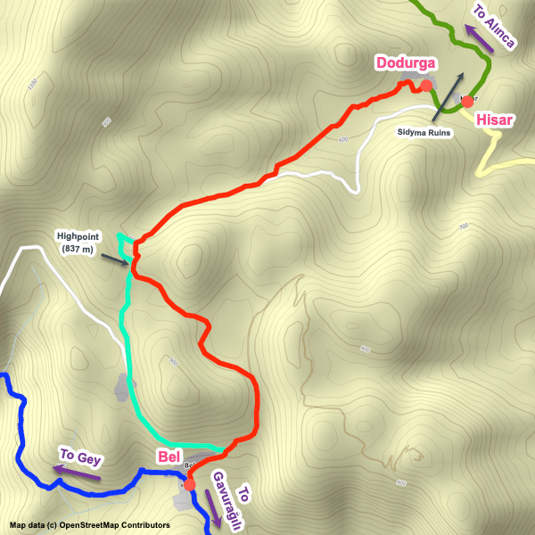
For route planning, there are more decision points in this region than elsewhere. The main decision you’ll need to make is between Alınca and Bel where you’ll need to choose whether to follow the alternate variant to the Sidyma ruins (by the village of Dodurga) or the main variant going via the village of Yediburunlar (Gey). Most go via Yediburunlar (more scenic and rugged) but if you are a history buff or if weather conditions are poor, the Sidyma option is worthwhile. If you are not a history buff, though, you’ll see plenty of ancient cities elsewhere along the trail.
This is the busiest part of the Lycian Way, though even here you certainly don’t have to worry about crowds unless you encounter the rare large group passing by. There are many more day-hikers here, though, than you will see elsewhere along the trail. Also, those who opt to walk only a shortened version of the trail typically choose this region (likely because of that ‘microcosm’ mentioned above!).
This is a mountainous region with near-constant ascending and descending, sometimes quite steeply. The trail is generally well way-marked in this region, though there are still plenty of places where you’ll need to be extra-alert. The trail surface is frequently rocky and uneven, as is common over much of the Lycian Way. Water isn’t a major problem as you’ll regularly pass through communities where you can top-up.
In general, the difficulty level in this region is a bit less than in some other regions though there are still some challenging stretches. Accommodation in this region is plentiful and there are lots of places for wild camping.
For route planning, there are more decision points in this region than elsewhere. The main decision you’ll need to make is between Alınca and Bel where you’ll need to choose whether to follow the alternate variant to the Sidyma ruins (by the village of Dodurga) or the main variant going via the village of Yediburunlar (Gey). Most go via Yediburunlar (more scenic and rugged) but if you are a history buff or if weather conditions are poor, the Sidyma option is worthwhile. If you are not a history buff, though, you’ll see plenty of ancient cities elsewhere along the trail.


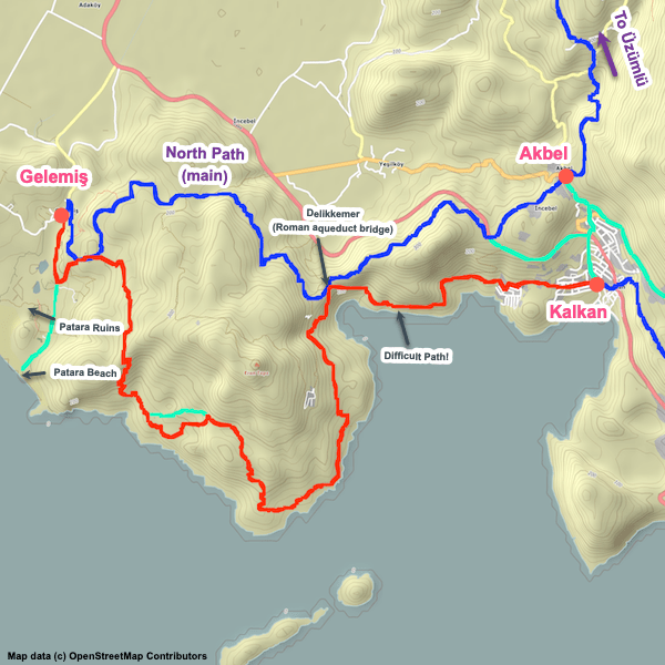
Region 02: Letoon – Kalkan
This region is largely a delta with an endless sea of white greenhouses. As you’d expect with a delta, there’s a lengthy history of civilization in the area, including three notable ancient cities (Letoon, Xanthos, and Patara).
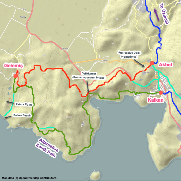
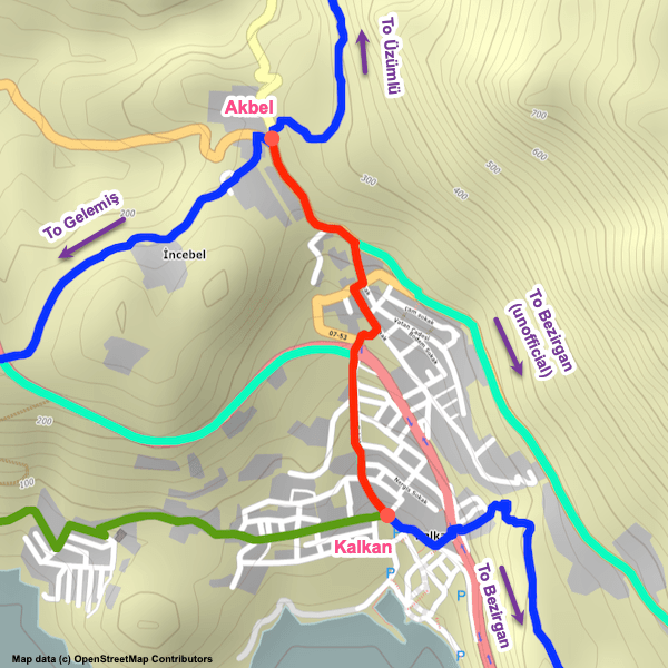
The Lycian Way follows on or alongside roads through much of this section and when off-road largely follows directly on the remains of a Roman aqueduct including at one point crossing an attractive, somewhat narrow aqueduct bridge. An historical highlight, in addition to the three cities, is Delikkemer, a huge, very impressive aqueduct bridge still in decent shape. For relaxation, Patara Beach is very nice (and sandy rather than pebble, which is a nice change!).
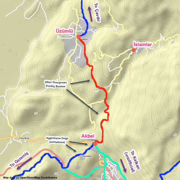
Note that in some parts, the trails can be over-grown with nasty prickly bushes depending on how recently the trail maintenance team has been in the area. Also, aggressive dogs have sometimes been a problem, particularly in and around Akbel.
This region tends to have a lot of construction going on (endlessly…). It’s not unusual for the Lycian Way to be impacted or outright blocked, necessitating a little exploring or even back-tracking to find a way around the blockage. Watch the way-markings carefully and when you encounter blockages look around for any cairns other hikers might have erected to point the way.
For most, exploring the excellent ruins and walking on the aqueduct is what make this region worthwhile. Despite the historical sites, though, some hikers find the delta relatively boring. If you need to shave a few days off your hike, this is a good area to do it. Many skip it entirely, taking a taxi / dolmuş from Karadere Beach (near the Pydnai ruins, to the west of Letoon) to Kalkan and continuing their hike from there (maybe with a day-trip by taxi to see the historical sites of the delta).
The Lycian Way follows on or alongside roads through much of this section and when off-road largely follows directly on the remains of a Roman aqueduct including at one point crossing an attractive, somewhat narrow aqueduct bridge. An historical highlight, in addition to the three cities, is Delikkemer, a huge, very impressive aqueduct bridge still in decent shape. For relaxation, Patara Beach is very nice (and sandy rather than pebble, which is a nice change!).
Note that in some parts, the trails can be over-grown with nasty prickly bushes depending on how recently the trail maintenance team has been in the area. Also, aggressive dogs have sometimes been a problem, particularly in and around Akbel.
This region tends to have a lot of construction going on (endlessly…). It’s not unusual for the Lycian Way to be impacted or outright blocked, necessitating a little exploring or even back-tracking to find a way around the blockage. Watch the way-markings carefully and when you encounter blockages look around for any cairns other hikers might have erected to point the way.
For most, exploring the excellent ruins and walking on the aqueduct is what make this region worthwhile. Despite the historical sites, though, some hikers find the delta relatively boring. If you need to shave a few days off your hike, this is a good area to do it. Many skip it entirely, taking a taxi / dolmuş from Karadere Beach (near the Pydnai ruins, to the west of Letoon) to Kalkan and continuing their hike from there (maybe with a day-trip by taxi to see the historical sites of the delta).


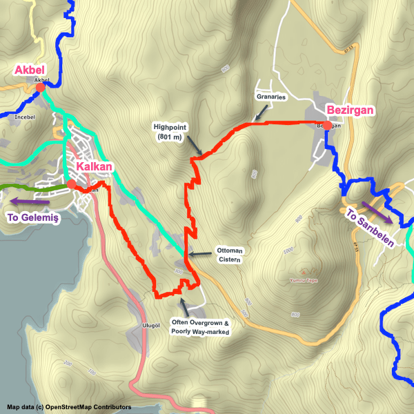
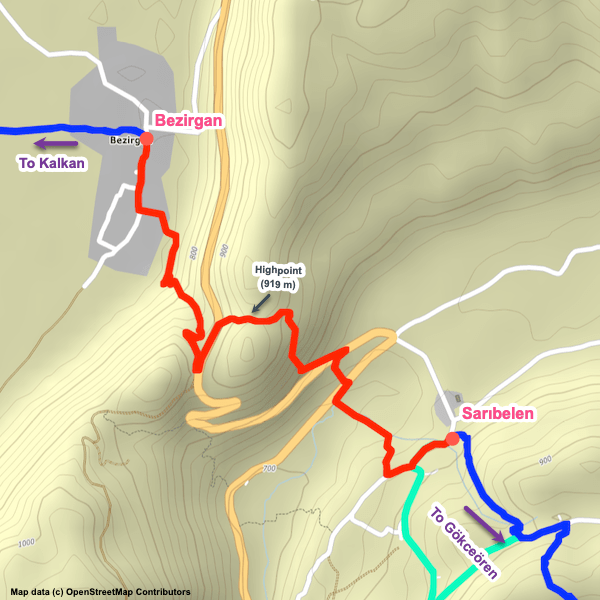
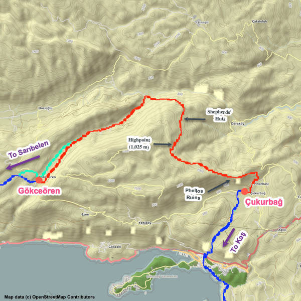
Region 03: Kalkan – Kaş
This is a beautiful, mountainous region rising above the coastal towns of Kalkan to the west and Kaş to the east, with steep slopes above both endpoints. There are several villages along the way offering accommodation, water, and limited supplies. Camping isn’t a problem, with lots of good locations.
For history buffs, the Phellos ruins are notable. Both Kalkan and Kaş are tourist towns and you’ll find many expatriates (especially British) in both. Kaş is a common rest-day location for many hikers though Kalkan is also a good option (albeit typically a more expensive one). Kaş has an outdoor supplies shop if you need to pick up any gear or get repairs done.
Way-finding is moderately good, but there are several potentially confusing spots where you might have to be extra-alert. The trail surface is generally good though there are a few places that can be troublesome in wet conditions. Sometimes the trail can get over-grown by prickly bushes – long-pants might be advisable.
For planning purposes, there are no major variants to consider. If you are not over-nighting in Çukurbağ, some hikers opt to take a dolmuş between Çukurbağ and Kaş, given that the section between Gökceören and Çukurbağ is a long and tiring one. Thus, if you are over-nighting in Kaş you can bypass the steep slope above the town.


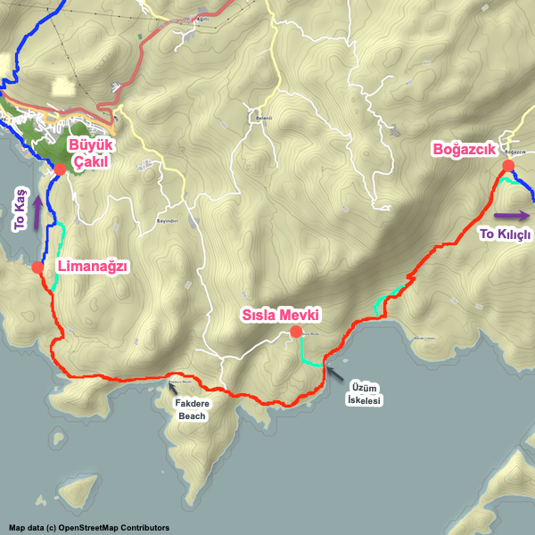
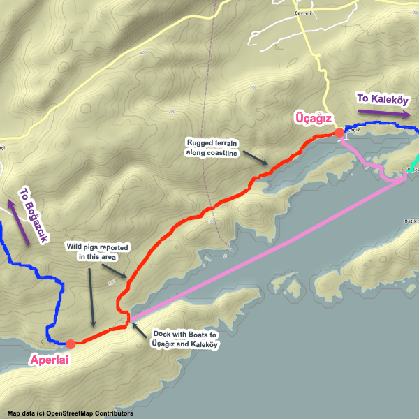
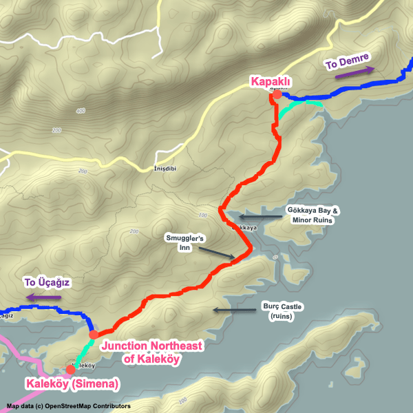
Region 04: Kaş – Demre
This is a gorgeous stretch of the Lycian Way that roughly hugs the coastline the whole way. There’s lots of beautiful views, several ancient cities (Aperlai, Apollonia, Talmussa, Andriake, and Myra), lots of random ruins scattered here and there, a near-infinite number of wonderful coves and inlets, and very attractive fishing villages at Üçağız and Kaleköy.
While there are no major elevation changes, the trail in this region still involves near-constant small ascents and descents over rugged, rocky terrain, making this region more challenging than it might initially seem. Give yourself a bit of extra time and watch your footing carefully as the trail surface is often very uneven. Note: There are lots of places along this stretch where you could bypass some difficult terrain using nearby rural roads / tracks. If you are getting tired or simply want to pick up your pace a bit, look at the map for options.
Way-finding is generally pretty good in this region, other than the Main variant near Demre where things can be confusing in some places.
There are a number of villages along this stretch with accommodations. Some have limited supplies available as well. Note that water can sometimes be a problem along this stretch; carry a bit more with you until you are sure fountains and other sources are usable. There are lots of camping options available, yet less than you might at first assume – the extremely rocky terrain makes it difficult sometimes to find a suitable, flat, clear place to pitch a tent. Make sure you don’t leave it too close to dark before you start looking for a spot for the night. We’ve flagged popular camping spots but there are many others.
For planning purposes, this section is mostly very straight-forward except at the Demre end. There are two options there, one (the official path) ascends up and over Demre via the village of Gürses, entering / exiting the town from the north, while the alternate variant follows the coast via Çayağzı (and also has the benefit of passing the nice Andriake ruins). We highly recommend the alternate coastal variant (and based on feedback we’ve received, it seems most hikers opt to go that way).


Region 05: Demre – Finike
This is typically a three-day mountainous section that has no accommodation options and thus normally requires camping. If you really want to do this section, though, there is a way to do it without camping if you are willing to organize some logistics. See this article for details.
Much of this section is very remote. Water can sometimes be an issue – there are lots of water sources (wells, springs) but they can sometimes be dry. You’ll often encounter shepherds along the way and you can often purchase water bottles, snacks, and other items from them, especially at Yatıkardıç Yayla (plateau high up on the mountain which shepherds typically use as a ‘base’). However, this should not be relied upon. Until you are sure about current water conditions, take extra with you.
The trail is steep and rugged. It’s an attractive hike with beautiful vistas. Demre is notable for the excellent Myra ancient city, as well as the Church of St. Nicholas. Up in the mountains, you’ll be able to explore both the Alakilise ruins (a popular place to wild camp) and the Belos ruins.
Note that there are roads / tracks criss-crossing the mountain. If conditions require it, head for the nearest road.
This portion of the Lycian Way can be easily skipped via dolmuş. Some opt to walk between Demre and Finike along the main road, D400, which hugs the coastline between the two communities. However, it is a busy road and a long, very unappealing walk. If you aren’t hiking over the mountain, we recommend going via dolmuş.


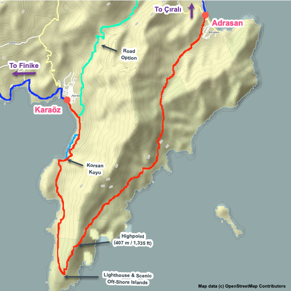
Region 06: Finike – Çıralı
This region can be broken down into three sub-regions: a coastline walk on pavement through farm country (yep, greenhouses everywhere) between Finike and Karaöz, a remote hike around the beautiful Gelidonya peninsula between Karaöz and Adrasan, and an ascent / descent of a mountain between Adrasan and Çıralı.
The walk between Finike and Karaöz is arguably the most boring, uninteresting part of the Lycian Way. It is a long flat walk along / near the shoreline, entirely on pavement, passing greenhouse after greenhouse. Most people walk it in a single day though it can be split into two days if necessary. There are several accommodation options along the way, along with a few small markets. Based on feedback we’ve received, a huge percentage of Lycian Way hikers simply skip it, taking a bus / taxi or hitch-hiking over the stretch.
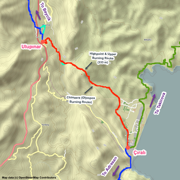
In a striking contrast, Karaöz to Çıralı is incredibly beautiful. Karaöz toAdrasan involves hiking around a gorgeous peninsula with a lighthouse at the point and great views of several iconic little islands slightly off-shore. The eastern half is rugged. Water can sometimes be a problem though often isn’t; carry extra until you can confirm the state of fountains along the way. Between Adrasan and Çıralı, you’ll hike over a mountain and pass through the excellent Olympos ruins.
Accommodation options are plentiful in the communities along the way, especially in Adrasan and Çıralı, both of which are tourist towns and, at last count, had approximately 1.2 million guesthouses available between them (and in the summer months every single one of them is fully booked!). Karaöz has a few places, as does Finike. There’s lots of camping options between Karaöz and Çıralı.
Way-finding is generally good in this region though the area near the Olympos ruins can sometimes be confusing (in part because they’ve made route changes there recently). Note that the Lycian Way passes directly through the ancient city so there is an admission payable.
The walk between Finike and Karaöz is arguably the most boring, uninteresting part of the Lycian Way. It is a long flat walk along / near the shoreline, entirely on pavement, passing greenhouse after greenhouse. Most people walk it in a single day though it can be split into two days if necessary. There are several accommodation options along the way, along with a few small markets. Based on feedback we’ve received, a huge percentage of Lycian Way hikers simply skip it, taking a bus / taxi or hitch-hiking over the stretch.
In a striking contrast, Karaöz to Çıralı is incredibly beautiful. Karaöz to
Accommodation options are plentiful in the communities along the way, especially in Adrasan and Çıralı, both of which are tourist towns and, at last count, had approximately 1.2 million guesthouses available between them (and in the summer months every single one of them is fully booked!). Karaöz has a few places, as does Finike. There’s lots of camping options between Karaöz and Çıralı.
Way-finding is generally good in this region though the area near the Olympos ruins can sometimes be confusing (in part because they’ve made route changes there recently). Note that the Lycian Way passes directly through the ancient city so there is an admission payable.


Region 07: Çıralı – Göynük Yayla
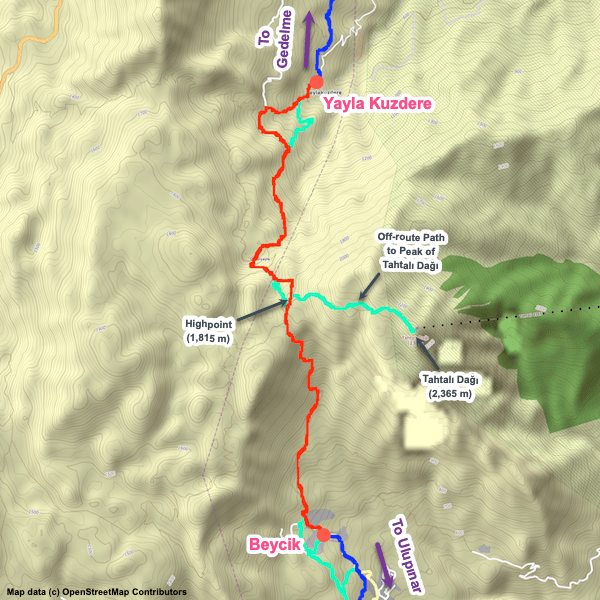
There are two major variants through this region, both of which are official paths, one via an interior mountain path and one that is partially along the coast and partially mountainous. We deem the interior path as the ‘Main’ variant and the coastal variant as the Alternate, though both are excellent options and neither is necessarily ‘better’. Our personal preference is for the interior path, but it’s a tough choice. If you opt for the coastal variant, we highly recommend a side-hike up to the burning rocks above Çıralı (especially nice at night!). The Main variant passes directly through them.
The interior variant is the more challenging option, with more stretches of rugged terrain and more elevation changes. It passes close to the dramatic peak of Tahtalı Dağı. Optionally, there’s an unofficial side-hike you can take (in good weather conditions) from the Lycian Way to the peak. You can also take a fantastic cable car ride to / from the peak and the coast, close to the path of the coastal Lycian Way variant. The views from the peak are spectacular if conditions are clear.
The coastal variant hugs the coastline between Çıralı and the Phaselis ruins just east of the town of Tekirova. From there, it ascends up into the mountains, sometimes quite steeply and sometimes over rugged terrain. Along the coast itself, the path is generally good and often follows quiet tracks through woodlands. There are numerous attractive coves / inlets.
Be cautious with accommodation planning on the interior variant (and the coastal variant when in the mountains) as some communities have very limited accommodation options that might not be available for walk-in or last-minute bookings. Also, currently there are no accommodation options available in the village of Gedelme as the hotel there has closed. It is possible, though, to take a taxi to accommodations available nearby.
Accommodation options are good along the coastal stretch, at least until it heads up into the mountains. Note, don’t be surprised to see a lot of signage in Russian along the coastal stretch (especially in / around Tekirova) – there are plenty of resorts in the area that cater to Russian tourists.
Water is generally not a problem along either variant, though as always be suitbly cautious.


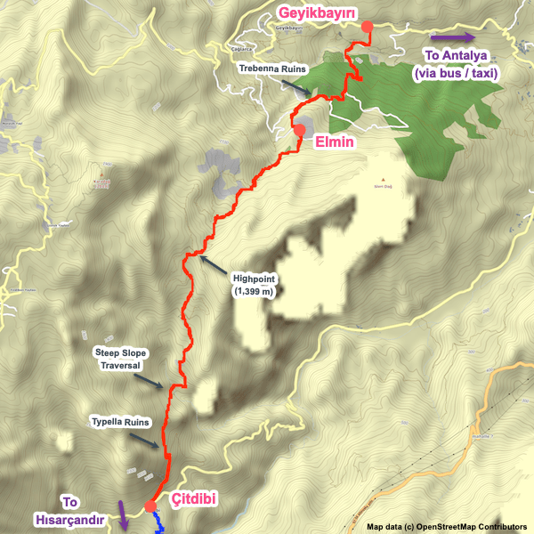
Region 08: Göynük Yayla – Geyikbayırı
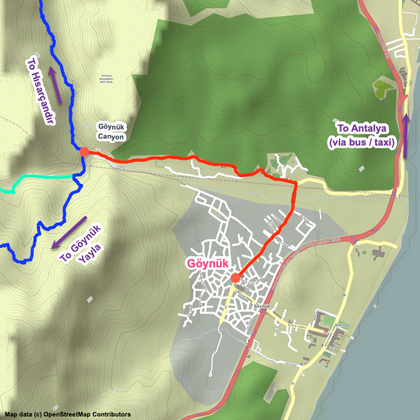
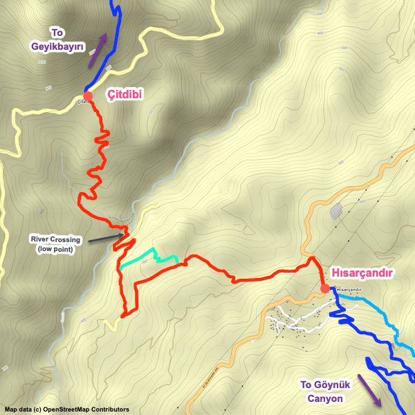
This is a mountainous, extremely beautiful region. Of particular note is the stretch between Göynük Yayla and Göynük Canyon which for many is a highlight of the trail. It is a very rugged, challenging stretch, though, and sometimes (mainly in early spring) can have a couple of difficult spots due to high water levels that might require some waist-high wading.
From Göynük Canyon to Geyikbayırı is rugged mountain hiking, with lots of elevation change, sometimes-difficult terrain, and generally poorer trail quality and way-finding than elsewhere on the Lycian Way. Trails over-grown with prickly bushes also seem to be a more frequent problem on this stretch, though of course it always depends on how recently the trail maintenance team has been through the area. It is a very attractive stretch, but also sometimes can be a frustrating one for many hikers.
Accommodation options are somewhat limited throughout this region, though usually you won’t have too much problem. Camping options are plentiful. Water is usually not an issue.
The town of Göynük is available a few kilometres off-route of Göynük Canyon, with a full range of amenities. Many head into town to stay at a guesthouse and for supplies. It is usually easy to arrange a taxi or pick-up / drop-off service by your guesthouse operator if you don’t want to walk. Many hikers also opt to start / finish their hike in Göynük – dolmuş and taxi service is available to / from Antalya. Some also opt to start / finish in the village of Hısarçandır, which until 2014 was the original eastern endpoint of the Lycian Way.
Compared to the rest of the Lycian Way, there aren’t a lot of historical sites / ruins along this stretch. There are two ancient cities (Typella and Trebenna) though neither are as impressive as sites elsewhere along the trail. The highlight of this region is simply the beautiful mountain terrain.


Bonus: Connecting with the St. Paul’s Trail
In 2022, way-markings and signage were implemented to connect the Lycian Way’s eastern endpoint with the southern endpoint of the excellent (and recommended) St. Paul’s Trail making it possible to do both trails as a single, lengthy adventure. We haven’t hiked this extension yet and don’t have GPS tracks for it. Once we do, we’ll add more info here.
If you’ve hiked this new extension, we’d love to get your feedback. And, of course, we’d be grateful if you’d share your photo collection and GPS tracks with us, too. Thanks!
If you’ve hiked this new extension, we’d love to get your feedback. And, of course, we’d be grateful if you’d share your photo collection and GPS tracks with us, too. Thanks!