Main Path (Extended Trail)
Kayaköy – Ovacık
(direct option)
ID: 
63

This is the direct option between Kayaköy and the official Lycian Way start / finish point in Ovacık, typically part of a single stage between Fethiye and Ovacık.

Coastal view between Kayaköy and Ovacık
Image credit:  
Darren Moens
, All rights reserved

Essentials

Kayaköy (village)
Ovacık (town)
WNW-ESE section with Kayaköy to the WNW and Ovacık (and adjacent sister-town of Hisarönü) to the ESE.
Hilly section with some moderately steep portions. The typical slope on the Kayaköy side is about 13.5% with some stretches at 18%+. The slope is gentler on the Ovacık side at about 9.5%.
The path is mostly on rugged but reasonably good-quality mountain trails through attractive woodlands, with roads on the very east end and paved but rugged (broken / decaying) footpaths through Kayaköy’s ghost town.
Moderate way-finding. There are blazes and it is generally clear which way to go.

Metrics

Select the tab below corresponding to the direction you plan to walk.
Towards Ovacık:
Towards Kayaköy:
5.5 km / 3.4 mi
Distance
360 m / 1,181 ft
Ascent
220 m / 722 ft
Descent
~2.5 hrs
Duration
Elevation chart.
5.5 km / 3.4 mi
Distance
220 m / 722 ft
Ascent
360 m / 1,181 ft
Descent
~2.5 hrs
Duration
Elevation chart.

Handy Things to Know

The following notes are gathered from our own experiences and from feedback sent to us by other hikers. Let us know how we can improve these notes – and thanks!

Water

  • There’s a water fountain available but it is often dry. Load up on water before departing Kayaköy / Ovacık.

Highlights

  • Passes through the ‘ghost town’ ruins (which has a nominal admission fee). Give yourself some time to explore them.

Tips

  • For eastbound hikers, note that there are two main trails exiting from the ruins – in addition to this one there is a separate path that branches southwest which heads towards Ölüdeniz. The path you want (for  Ovacık) is the one that departs from the east side of the ruins.

Route Planning

  • This is one of two popular alternatives leading to / from the E / SE of Kayaköy. This option connects directly to Ovacık. The other option connects with the popular beach community of Ölüdeniz, from which you can then make your way to Ovacık. The two options merge / split at a junction on the hillside in the Kayaköy ghost town.
  • If you are overnighting in Ovacık, there may be some side trails you can optionally use to connect with this path depending on the location of your hotel /guesthouse (rather than first heading to the Ovacık trailhead). Check the map for options.

Alerts / Hazards

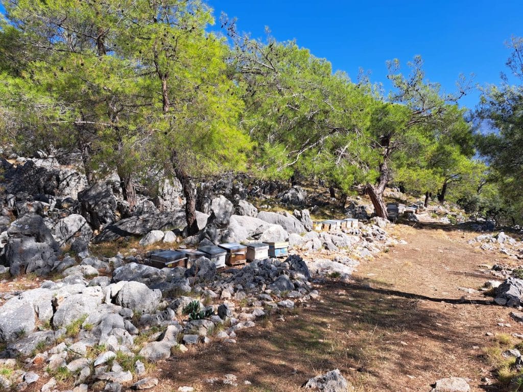
  • There are often bee-houses near the highpoint (and you’ll sometimes see their beekeepers). Give the bee-houses a wide berth and you shouldn’t be bothered.

Camping

  • Wild camping spots available, though they are limited due to the angle of the slope in most areas and the fairly thick woodlands.

Attractions & Highlights

Notable highlights along the trail and at either endpoint include:
  • Ghost Town Ruins in Kayaköy
    Historical Site
    Kayaköy ‘Ghost Town’
    In Kayaköy

Accommodations

Here’s what we’re currently tracking for this trail section:
  • Annotated map of Han Camping & Pension
    Guesthouse
    Han Camping & Pension
    In Kayaköy
  • Annotated map of Misafir Evi in Kayaköy
    Guesthouse
    Misafir Evi
    In Kayaköy
  • Annotated map of Selçuk Pension in Kayaköy
    Guesthouse
    Selçuk Pension
    In Kayaköy
  • Annotated map of Everest Lodge in Ovacık
    Hotel
    Everest Lodge
    In Ovacık
  • Annotated map of Montana Pine Resort in Ovacik
    Hotel
    Montana Pine Resort
    In Ovacik
  • Annotated map of Ölüdeniz Hostel & Suites in Ovacık
    Hostel
    Ölüdeniz Hostel & Suites
    In Ovacık

Wild Camping Locations

Here are the wild camping locations that we’re currently tracking along this trail section:
  • Wild campsite between Kayaköy & Ovacık
    Wild Campsite
    Wild Campsite
    Between Kayaköy & Ovacık
  • Map of Wild Campsite between Kayaköy & Ovacık [721] [CE1885]
    Wild Campsite
    Campsite
    Between Kayaköy & Ovacık

Water Sources

Here are the water sources that we’re currently tracking along this trail section or at either endpoint:
  • Map of Water Fountain in Kayaköy [753] [CE610]
    Water Source
    Water Fountain
    In Kayaköy
  • Map of Water Fountain by Mosque in Kayaköy [754] [CE420]
    Water Source
    Water Fountain
    In Kayaköy
  • Map of Water Fountain in Kayaköy [751] [CE837]
    Water Source
    Water Fountain
    in Kayaköy
  • Wild campsite between Kayaköy & Ovacık
    Water Source
    Fountain
    Between Kayaköy & Ovacık

Where to Next?

From Ovacık:

  • Map showing the Lycian Way between Ölüdeniz and Ovacık.
    Unofficial Alternative
    Ölüdeniz – Ovacık
    Distance
    2.8 km / 1.7 mi
    Ascent
    300 m / 984 ft
    Descent
    8 m / 26 ft
    Est. Duration
    1.2
    Unappealing connector section between Ölüdeniz and the Lycian Way’s official start / finish point at the edge of Ovacık. Entirely alongside a busy, steep road. Many people just take a dolmuş.
  • Map showing the Lycian Way between Ovacık and Faralya.
    Main Path
    Ovacık – Faralya
    Distance
    12.8 km / 8.0 mi
    Ascent
    765 m / 2,510
    Descent
    735 m / 2,411 ft
    Est. Duration
    5.8
    Mountain section between the official Lycian Way start / finish point at the southern end of Ovacık and the village of Faralya on the opposite side of Babadağ (‘Father Mountain’).

From Kayaköy:

  • Map showing Lycian Way between Fethiye and Kayaköy.
    Main Path (extended)
    Fethiye – Kayaköy
    Distance
    8.8 km / 5.5 mi
    Ascent
    445 m / 1,460 ft
    Descent
    320 m / 1,050 ft
    Est. Duration
    3.6
    Optional extended section of the Lycian Way (which technically starts / ends in Ovacık), typically part of a stage connecting Fethiye with Ovacık and/or Ölüdeniz.   While there are certainly nicer, more memorable sections elsewhere along the trail, this makes for a pleasant, easy ‘warm-up’ for those just starting their hike or a gentle conclusion for those ending their adventure in Fethiye.
  • Map showing Lycian Way between Kayaköy and Ölüdeniz.
    Optional Path
    Kayaköy – Ölüdeniz
    Distance
    5.1 km / 3.2 mi
    Ascent
    210 m / 689 ft
    Descent
    365 m / 1,198 ft
    Est. Duration
    2.25
    This off-route variant ascends and descends a modest-sized hill, with very nice views down on Ölüdeniz’s famous lagoon during the descent (for eastbound walkers). Passes through Kayaköy’s intriguing ‘ghost town’ ruins.

Pretty Pictures

Sometimes nothing beats a good photo. Or even a bad photo! If you’d like to share some or all of your photo collection with the Trekopedia community, contact us at photos@trekopedia.com and we can arrange a transfer of them. And thanks!
All photos are copyright by their respective owners and are used with permission.
  • Blaze on rock between Kayaköy and Ovacık
    Blaze on rock between Kayaköy and Ovacık
    Photo by 
    Rebecca Scheer
     – 
    Fall 2022
  • Woodland path between Kayaköy and Ovacık
    Woodland path between Kayaköy and Ovacık
    Photo by 
    T Roszkowski
     – 
    Feb 2022
  • Bee houses on path between Kayaköy and Ovacık.
    Bee houses by path
    Photo by 
    Darren Moens
     – 
    Fall 2022
  • Coastal view between Kayaköy and Ovacık
    Coastal view between Kayaköy and Ovacık
    Photo by 
    Darren Moens
     – 
    Fall 2022

How You Can Help

Trail research is never actually done. Here’s some of what we’re looking for:
✅   More photos! Ideally with geo-location information in the metadata. In addition to using some photos on Trekopedia, we add them to our internal reference database which significantly helps us with trail research. The more photos, the better! If you are willing to share your collection with us, we’d be incredibly grateful. Let us know and we’ll arrange a transfer.

✅   Points of interest. Help us identify (and geo-locate) accommodations, attractions, restaurants, markets, trail waypoints, confusing or problematic junctions, difficult or hazardous places, water sources, and so on. 

✅   Tips & recommendations. Share your thoughts with other hikers.
In addition to the above, please see this article for information on more general ways you can help. Thanks!
0 0 votes
Article Rating
Subscribe
Notify of
guest
0 Comments
Inline Feedbacks
View all comments
0
Would love your thoughts, please comment.x
()
x