Main Path
Beycik – Yayla Kuzdere
ID: 
53

Beautiful mountain section that is part of the interior route between Çıralı and Göynük Yayla.


This section involves steady ascending and descending and is quite steep almost the entire way. It reaches the highpoint for the entire Lycian Way, close to the peak of Tahtalı Dağı.

Shepherd with her goats.
Image credit:  
Anna Flack
, All rights reserved

Essentials

Beycik (village)
Yayla Kuzdere (village)
S–N section with Yayla Kuzdere to the N.
This section traverses the highpoint of Tahtalı Dağı and thus has a long, steady slope on both sides. Overall, the southern slope is slightly steeper at about 18% (versus about 17% on the northern slope). However, the northern slope has much steeper stretches along it, frequently exceeding 25%.
Mostly mountain footpaths through rugged, rocky terrain.
Way-finding is moderate. Generally, the way is clear but there are multiple junctions where the correct path can be confusing.

Metrics

Select the tab below corresponding to the direction you plan to walk.
Towards Yayla Kuzdere:
Towards Beycik:
12.5 km / 7.8 mi
Distance
1,186 m / 3,891 ft
Ascent
1,128 m / 3,701 ft
Descent
~7.5 hrs
Duration
Elevation chart.
12.5 km / 7.8 mi
Distance
1,128 m / 3,701 ft
Ascent
1,186 m / 3,891 ft
Descent
~7.5 hrs
Duration
Elevation chart.

Handy Things to Know

The following notes are gathered from our own experiences and from feedback sent to us by other hikers. Let us know how we can improve these notes – and thanks!

Water

  • Multiple water sources are available that are generally reliable for much of the year (other than winter), especially on the N side of the highpoint.
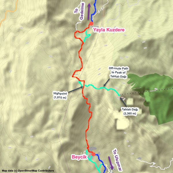
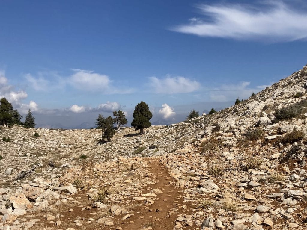
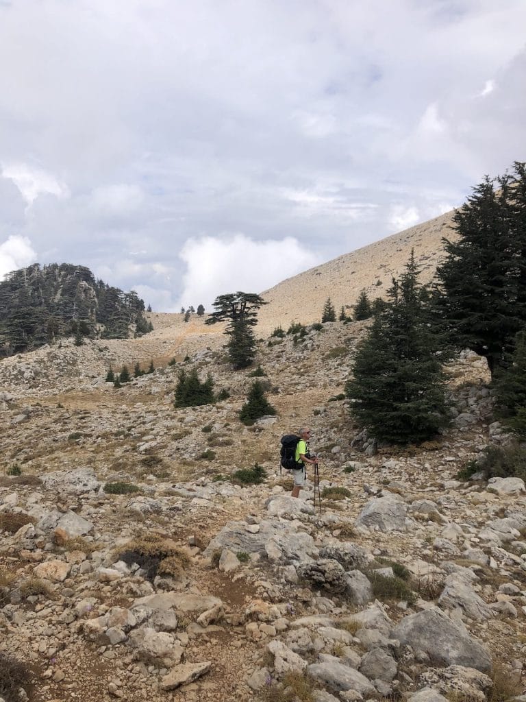
Highlights

  • Passes near to the peak of Tahtalı Dağı, which is also the highpoint of the entire Lycian Way.
  • Very attractive, scenic section. A favourite for many people.

Tips

  • Near the high point of this section is an off-route path you can take to hike to the peak of Tahtalı Dağı . Well worth considering for the breathtaking views. Note that there is a cable car station at the peak that leads down to the coast (one of the longest cable car rides in the world). There is a restaurant there as well. We have a GPS track for this off-route path.
  • You’ll frequently meet shepherds along this section. They are usually friendly and happy to see you.

Alerts / Hazards

  • Caution should be used any time you traverse over snow in this region (especially if climbing to the peak) as it could be ‘capping’ dangerous crags / gullies.

Accommodations

  • Some informal pensions are available in Yayla Kuzdere where you’ll typically get a very warm, friendly welcome.

Camping

  • There are several excellent camping spots, in scenic locations, available on this section.

Amenities

  • There’s sometimes an impromptu café available by one of the water sources during peak season.

Accommodations

Here’s what we’re currently tracking for this trail section:
  • Annotated map of Panorama Camping, Bungalows, & Restaurant in Beycik
    Bungalows
    Panorama Camping, Bungalows, & Restaurant
    In Beycik
  • Camping at Ali's Riviera Restaurant in Beycik
    Commercial Camping
    Camping at Ali’s Riviera Restaurant
    In Beycik
  • Annotated map of Sevim Abla's House in Yayla Kuzdere
    Guesthouse
    Sevim Abla’s House
    In Yayla Kuzdere
  • Annotated map of Süleyman Bey's House in Yayla Kuzdere
    Guesthouse
    Süleyman Bey’s House
    In Yayla Kuzdere

Wild Camping Locations

Here are the wild camping locations that we’re currently tracking along this trail section:
  • Campsite Between Beycik and Yayla Kuzdere
    Wild Campsite
    Campsite
    Between Beycik and Yayla Kuzdere
  • Campsite Between Beycik and Yayla Kuzdere
    Wild Campsite
    Campsite
    Between Beycik and Yayla Kuzdere
  • Campsite Between Beycik and Yayla Kuzdere
    Wild Campsite
    Campsite
    Between Beycik and Yayla Kuzdere
  • Campsite between Beycik and Yayla Kuzdere
    Wild Campsite
    Campsite
    Between Beycik and Yayla Kuzdere

Water Sources

Here are the water sources that we’re currently tracking along this trail section or at either endpoint:
  • Fountain / Rest Area Near Mosque in Beycik
    Water Source
    Fountain / Rest Area Near Mosque
    In Beycik
  • Fountain in Beycik
    Water Source
    Fountain / Rest Area
    In Beycik
  • Hose With Small Basin Between Beycik and Yayla Kuzdere
    Water Source
    Hose With Small Basin
    Between Beycik and Yayla Kuzdere
  • Spout / Thin Hose With Small Basin Between Beycik and Yayla Kuzdere
    Water Source
    Spout / Thin Hose With Small Basin
    Between Beycik and Yayla Kuzdere
  • Spring Water From PVC Pipe Between Beycik and Yayla Kuzdere
    Water Source
    Spring Water From PVC Pipe
    Between Beycik and Yayla Kuzdere
  • Well with PVC Pipe Between Beycik and Yayla Kuzdere
    Water Source
    Well with PVC Pipe
    Between Beycik and Yayla Kuzdere
  • Fountain Between Beycik and Yayla Kuzdere
    Water Source
    Fountain
    Between Beycik and Yayla Kuzdere
  • Spring Between Beycik and Yayla Kuzdere
    Water Source
    Spring
    Between Beycik and Yayla Kuzdere
  • Water Source Between Beycik and Yayla Kuzdere
    Water Source
    Water Source
    Between Beycik and Yayla Kuzdere
  • Fountain by Rest Platform at Edge of Yayla Kuzdere
    Water Source
    Fountain by Rest Platform
    At Edge of Yayla Kuzdere
  • Fountain at Mosque in Yayla Kuzdere
    Water Source
    Fountain at Mosque
    In Yayla Kuzdere
  • Fountain in Yayla Kuzdere
    Water Source
    Fountain
    In Yayla Kuzdere

Where to Next?

From Yayla Kuzdere:

  • Map of the Lycian Way between Yayla Kuzdere and Gedelme.
    Main Path
    Yayla Kuzdere – Gedelme
    Distance
    7.0 km / 4.3 mi
    Ascent
    238 m / 781 ft
    Descent
    457 m / 1,499 ft
    Est. Duration
    3.0
    Mountain section linking Yayla Kuzdere and Gedelme that is part of the interior route between Çıralı and Göynük Yayla.

From Beycik:

  • Map of the Lycian Way between Ulupınar and Beycik.
    Main Path
    Ulupınar – Beycik
    Distance
    9.3 km / 5.8 mi
    Ascent
    818 m / 2,684 ft
    Descent
    256 m / 840 ft
    Est. Duration
    4.25
    Mountain section that is part of the ‘interior’ route between Çıralı and Göynük Yayla.

Pretty Pictures

Sometimes nothing beats a good photo. Or even a bad photo! If you’d like to share some or all of your photo collection with the Trekopedia community, contact us at photos@trekopedia.com and we can arrange a transfer of them. And thanks!
All photos are copyright by their respective owners and are used with permission.
  • Rocky trail slightly north of highpoint
    Rocky trail slightly north of highpoint
    Photo by 
    Anna Flack
     – 
    Fall 2022
  • View from by highpoint on Tahtalı Dağı Near Peak [329]
    View from by highpoint of Tahtalı Dağı
    Photo by 
    Anna Flack
     – 
    Fall 2022
  • Looking towards Tahtalı Dağı from north of Beycik
    Looking towards Tahtalı Dağı from north of Beycik
    Photo by 
    Anna Flack
     – 
    Fall 2022
  • Rocky, rugged hillside near highpoint of Tahtalı Dağı
    Rocky, rugged hillside near highpoint of Tahtalı Dağı
    Photo by 
    Irene Dijkmans
     – 
    Fall 2022
  • Shepherd with her goats north of highpoint
    Shepherd with goat north of highpoint between Beycik & Yayla Kuzdere
    Photo by 
    Anna Flack
     – 
    Fall 2022
  • Shepherd with her goats.
    Shepherd with her goats north of highpoint between Beycik & Yayla Kuzdere
    Photo by 
    Anna Flack
     – 
    Oct 2022

How You Can Help

Trail research is never actually done. Here’s some of what we’re looking for:
✅   More photos! Ideally with geo-location information in the metadata. In addition to using some photos on Trekopedia, we add them to our internal reference database which significantly helps us with trail research. The more photos, the better! If you are willing to share your collection with us, we’d be incredibly grateful. Let us know and we’ll arrange a transfer.

✅   Points of interest. Help us identify (and geo-locate) accommodations, attractions, restaurants, markets, trail waypoints, confusing or problematic junctions, difficult or hazardous places, water sources, and so on. 

✅   Tips & recommendations. Share your thoughts with other hikers.
In addition to the above, please see this article for information on more general ways you can help. Thanks!
0 0 votes
Article Rating
Subscribe
Notify of
guest
0 Comments
Inline Feedbacks
View all comments
0
Would love your thoughts, please comment.x
()
x