Main Path
Göynük Yayla – Göynük Canyon
ID: 
57

Beautiful but frequently rugged and challenging mountain section with many great views and interesting rock formations, with the gorge itself a popular highlight.

Beautiful morning at Doga Camping & Bungalows between Göynük Yayla & Göynük Canyon
Image credit:  
T Roszkowski
, All rights reserved

Essentials

Göynük Yayla (village)
Göynük Canyon (landmark)
WSW–ENE section with Göynük Canyon to the ENE.
The W half of this section is a steady descent towards the E at an average slope of 14.8%, with some portions (in particular at the W edge of the section) exceeding 20%. The E half of the section is an ascent / descent of a good-sized hill (380 m elevation change on the W side and 705 m on the E side), with a slope of about 19.5% on the W side and an overall slope of 19.1% on the E side (though on the E side there are stretches where it exceeds 30%).
This is mostly a good-quality forest path though with some rugged, challenging portions. Some of it runs in or alongside the river bed.
Way-markings are mostly pretty good though as usual there are some junctions that can potentially be confusing.

Metrics

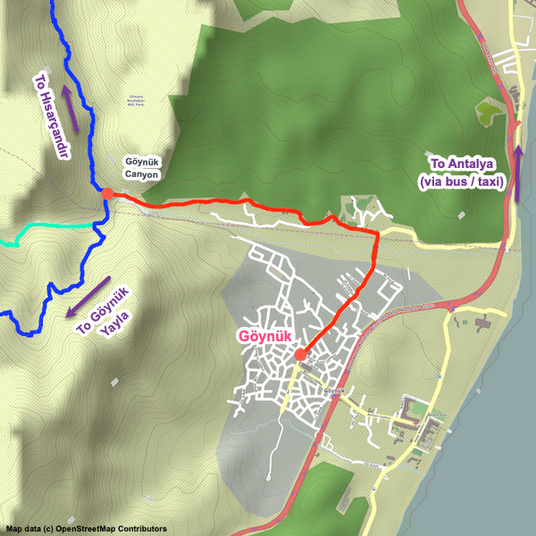
Select the tab below corresponding to the direction you plan to walk.
Towards Göynük Canyon:
Towards Göynük Yayla:
12.6 km / 7.8 mi
Distance
805 m / 2,641 ft
Ascent
1,574 m / 5,164 ft
Descent
~7.5 hrs
Duration
Elevation chart.
12.6 km / 7.8 mi
Distance
1,574 m / 5,164 ft
Ascent
805 m / 2,641 ft
Descent
~7.5 hrs
Duration
Elevation chart.

Handy Things to Know

The following notes are gathered from our own experiences and from feedback sent to us by other hikers. Let us know how we can improve these notes – and thanks!

Water

  • Water availability is generally good all year on this stretch, though error on the side of caution and carry a bit extra with you.

Tips

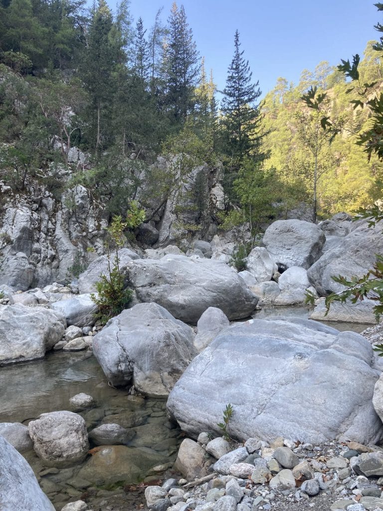
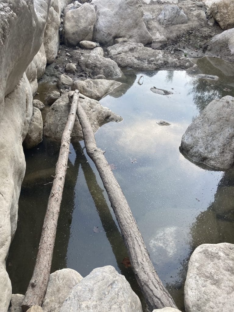
  • At the canyon gorge itself, you can cross the river in several different spots of varying difficulty using rocks and wooden logs. There is even a lengthy rope bridge suspended over the gorge.
  • There’s a wire fence blocking the trail in one location slightly N of Göynük Yayla with a wooden stile (steps / ‘ladder’ on each side) available to get over it.
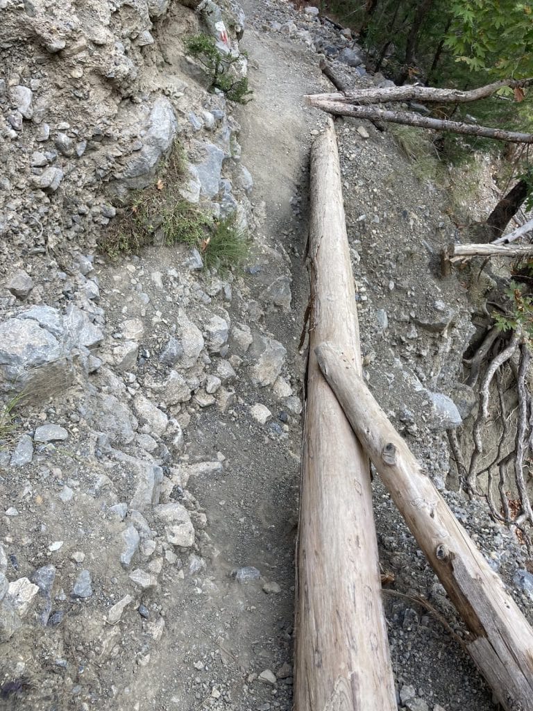
  • Using hiking poles is highly recommended for this section.

Alerts / Hazards

  • The path is sometimes quite rocky and you may need to contend with scree in some places.
  • There’s a short portion cutting across a steep hillside on a narrow path which can be tricky and even dangerous in wet / windy conditions. It’s marked on the map and in the waypoints. Watch your footing and use suitable caution.
  • There’s an area in the canyon where the river needs to be crossed (approx. 36.678368, 30.488947 and marked in our GPS waypoints) that may require wading. Normally it is knee-high or less, but sometimes can be deeper. You can also cross using some boulders (including one huge boulder), though caution needs to be taken and you may still need to wade a little bit.

Accommodations

  • For those heading towards Göynük Canyon, if you aren’t camping there are no accommodation options along this section (after leaving Göynük Yayla). However, you can follow the canyon road to the town of Göynük, staying at one of the pensions along the lower parts of the road – about 3 km / 1.9 mi away (making this section about 15.5 km / 9.6 mi – though it is usually easy to arrange transportation along the canyon road). There are lots of pensions in town. To continue the following day, you’ll need to walk (or arrange a ride) back up the canyon and then continue with the next section.

Camping

  • There are some good wild camping spots, though not as many as you might expect due to the uneven terrain and the lack of open spaces between trees / scrub.
  • Camping is not permitted within the canyon gorge itself.

Amenities

  • Snacks / beverages are typically available at the canyon gorge (i.e. the ENE endpoint).

Attractions & Highlights

Notable highlights along the trail and at either endpoint include:

Accommodations

Here’s what we’re currently tracking for this trail section:
  • Annotated map of Kamila Çoşkun's House / Café in Göynük Yayla
    Guesthouse
    Kamila Çoşkun’s House / Café
    In Göynük Yayla
  • Annotated map of Doga Camping & Bungalows Between Göynük Yayla & Göynük Canyon
    Bungalows
    Doga Camping & Bungalows
    Between Göynük Yayla & Göynük Canyon
  • Annotated map of Green Garden Otel Göynük in Göynük
    Hotel
    Green Garden Otel Göynük
    In Göynük

Wild Camping Locations

Here are the wild camping locations that we’re currently tracking along this trail section:
  • Campsite Between Göynük Yayla and Göynük Canyon
    Wild Campsite
    Campsite
    Between Göynük Yayla and Göynük Canyon
  • Campsite between Göynük Yayla and Göynük Canyon
    Wild Campsite
    Campsite
    Between Göynük Yayla and Göynük Canyon
  • Campsite Between Göynük Yayla and Göynük Canyon
    Wild Campsite
    Campsite
    Between Göynük Yayla and Göynük Canyon
  • Campsite between Göynük Yayla and Göynük Canyon
    Wild Campsite
    Campsite
    Between Göynük Yayla and Göynük Canyon
  • Campsite between Göynük Yayla and Göynük Canyon
    Wild Campsite
    Campsite
    Between Göynük Yayla and Göynük Canyon
  • Campsite Between Göynük Yayla and Göynük Canyon
    Wild Campsite
    Campsite
    Between Göynük Yayla and Göynük Canyon

Water Sources

Here are the water sources that we’re currently tracking along this trail section or at either endpoint:
  • Hose Between Göynük Yayla and Göynük Canyon
    Water Source
    Hose
    Between Göynük Yayla and Göynük Canyon
  • Spring between Göynük Yayla and Göynük Canyon
    Water Source
    Three-Trough Fountain
    Between Göynük Yayla & Göynük Canyon

Where to Next?

From Göynük Canyon:

  • Map of the Lycian Way between Göynük Canyon and Hısarçandır.
    Main Path
    Göynük Canyon – Hısarçandır
    Distance
    19.3 km / 12.0 mi
    Ascent
    1,795 m / 5,889 ft
    Descent
    1,000 m / 3,281 ft
    Est. Duration
    10.0
    Long section linking Göynük Canyon with the village of Hısarçandır. This used to be the first or last section of the Lycian Way (depending on which way you were walking) until it was extended in early 2014.
  • Map of the Lycian Way between Göynük Canyon and Göynük.
    Access Path
    Göynük Canyon – Göynük
    Distance
    4.0 km / 2.5 mi
    Ascent
    40 m / 131 ft
    Descent
    90 m / 295 ft
    Est. Duration
    1.25
    Optional detour off-route to the village of Göynük, where there are accommodation options as well as transport connections to Antalya and elsewhere.

From Göynük Yayla:

  • Map of the Lycian Way between Gedelme and Göynük Yayla.
    Main Path
    Gedelme – Göynük Yayla
    Distance
    9.2 km / 5.7 mi
    Ascent
    632 m / 2,073 ft
    Descent
    470 m / 1,542 ft
    Est. Duration
    4.25
    Mountain section linking Gedelme with Göynük Yayla that is part of the interior route between Çıralı and Göynük Yayla.
  • Map of the Lycian Way between Kuzdere and Göynük Yayla.
    Alternate Path
    Kuzdere – Göynük Yayla
    Distance
    17.6 km / 10.9 mi
    Ascent
    1,341 m / 4,400 ft
    Descent
    560 m / 1,837 ft
    Est. Duration
    7.75
    Beautiful mountain section that gives the legs a good workout. In addition to outstanding scenery, there’s a Roman bridge to cross along the way. This is part of the ‘coastal’ variant between Çıralı & Göynük Yayla (though this portion is entirely inland rather than on the coast).

Pretty Pictures

Sometimes nothing beats a good photo. Or even a bad photo! If you’d like to share some or all of your photo collection with the Trekopedia community, contact us at photos@trekopedia.com and we can arrange a transfer of them. And thanks!
All photos are copyright by their respective owners and are used with permission.
  • Log-built ladder at difficult crossing in Göynük Canyon.
    Log-built ladder at difficult crossing
    Photo by 
    Anna Flack
     – 
    Fall 2022
  • At Göynük Canyon trailhead
    View at Göynük Canyon (trailhead)
    Photo by 
    Anna Flack
     – 
    Fall 2022
  • View from stream crossing NE of Göynük Yayla
    View from stream crossing NE of Göynük Yayla
    Photo by 
    Anonymous
     – 
    Fall 2022
  • Public toilets between Göynük Yayla & Göynük Canyon
    Public toilets between Göynük Yayla & Göynük Canyon
    Photo by 
    Anonymous
     – 
    Fall 2022
  • Riverbed slightly west of the difficult crossing between Göynük Yayla & Göynük Canyon
    Riverbed slightly west of the difficult crossing between Göynük Yayla & Göynük Canyon
    Photo by 
    Anonymous
     – 
    Fall 2022
  • Using the step ladder in Göynük Canyon
    Using the step ladder in Göynük Canyon
    Photo by 
    Irene Dijkmans
     – 
    Fall 2022
  • Log at difficult hillside traversal (steep hillside)
    Log at difficult hillside traversal (steep hill)
    Photo by 
    Anna Flack
     – 
    Fall 2022
  • Stile between Göynük Yayla and Göynük Canyon
    Stile between Göynük Yayla and Göynük Canyon
    Photo by 
    Łukasz Ostojski
     – 
    Fall 2021

How You Can Help

Trail research is never actually done. Here’s some of what we’re looking for:
✅   More photos! Ideally with geo-location information in the metadata. In addition to using some photos on Trekopedia, we add them to our internal reference database which significantly helps us with trail research. The more photos, the better! If you are willing to share your collection with us, we’d be incredibly grateful. Let us know and we’ll arrange a transfer.

✅   Points of interest. Help us identify (and geo-locate) accommodations, attractions, restaurants, markets, trail waypoints, confusing or problematic junctions, difficult or hazardous places, water sources, and so on. 

✅   Tips & recommendations. Share your thoughts with other hikers.
In addition to the above, please see this article for information on more general ways you can help. Thanks!
0 0 votes
Article Rating
Subscribe
Notify of
guest
0 Comments
Inline Feedbacks
View all comments
0
Would love your thoughts, please comment.x
()
x