Main Path
Çavdır – Üzümlü
ID: 
25

Winding path through the northern part of the delta, linking Çavdır and Üzümlü. Mostly on hillsides with much of it directly on the remains of a Roman aqueduct.

Roman aqueduct bridge
Image credit:  
Anna Flack
, All rights reserved

Essentials

Çavdır (village)
Üzümlü (village)
NW–SE section with Üzümlü to the SE, passing around (but not through) the outskirts of the village of Çayköy.
Generally ascending towards the SE (i.e. towards Üzümlü) with a typical slope of about 8% though with a few short stretches nearing 20%.
Mostly quiet hillside paths plus walking directly on the remains of a Roman aqueduct, with a bit of road walking at either end as well as roughly in the middle when passing the N edge of Çayköy. You’ll cross over a Roman aqueduct bridge at one point. The path is wider and (mostly) easier on the SE portion where it is largely along grassy, woodland footpaths (though portions through scrubland are narrow).
Way-finding can sometimes be difficult through this section. Frequently over-grown portions of the trail can obscure blazes and construction can necessitate re-routing. Check our GPS tracks periodically to ensure you are still on the trail.

Metrics

Select the tab below corresponding to the direction you plan to walk.
Towards Üzümlü:
Towards Çavdır:
9.2 km / 5.7 mi
Distance
485 m / 1,591 ft
Ascent
280 m / 919 ft
Descent
~3.6 hrs
Duration
Elevation chart.
9.2 km / 5.7 mi
Distance
280 m / 919 ft
Ascent
485 m / 1,591 ft
Descent
~3.6 hrs
Duration
Elevation chart.

Handy Things to Know

The following notes are gathered from our own experiences and from feedback sent to us by other hikers. Let us know how we can improve these notes – and thanks!
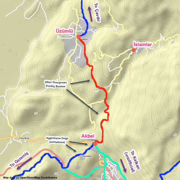
Water

  • Water fountains are available at the mosque roughly midway through this section (where there are also benches if you need a rest break).
  • Other than that, we aren’t aware of any water sources – the lack of water sources is sort of ironic given you spend most of this section actually walking on an aqueduct…

Highlights

  • A highlight of this section is the impressive Roman bridge / aqueduct you’ll cross. You’ll walk on / alongside the aqueduct for much of this region.
  • Discovering that some parts of the aqueduct system in the delta are still actually in use, taking water to crops after all this time, can be a pleasant shock!

Tips

  • Wearing long pants on this section is often worthwhile – if the prickly bushes are over-grown (as they often are!), they can be brutal on your legs.

Alerts / Hazards

  • Much of the hillside on either side of the Roman bridge can sometimes be quite overgrown (especially late in the season), making it difficult to navigate. Likewise for some of the hillside near the SE end.
  • Given the steep hillside, be cautious with your footing.
  • Take care crossing the Roman bridge, especially in wet and/or windy conditions (and if you’re lugging a heavy pack).

Camping

  • There are several good wild camping locations along the NE portion of this section. Elsewhere, though, the terrain is either too uneven, too rugged, or too overgrown for camping.

Attractions & Highlights

Notable highlights along the trail and at either endpoint include:
  • Roman Aqueduct Bridge Between Çavdır & Üzümlü
    Historical Site
    Roman Aqueduct Bridge
    Between Çavdır & Üzümlü

Accommodations

Here’s what we’re currently tracking for this trail section:
  • Annotated map of Villa Cennet Bahcesi in Üzümlü
    Guesthouse
    Villa Cennet Bahcesi
    In Üzümlü
  • Annotated map of Villa Lapaz Esintisi in Üzümlü
    Guesthouse
    Villa Lapaz Esintisi
    In Üzümlü

Wild Camping Locations

Here are the wild camping locations that we’re currently tracking along this trail section:
  • Campsite Between Çavdır & Üzümlü
    Wild Campsite
    Campsite
    Between Çavdır & Üzümlü
  • Campsite Between Çavdır & Üzümlü
    Wild Campsite
    Campsite
    Between Çavdır & Üzümlü
  • Campsite Between Çavdır & Üzümlü
    Wild Campsite
    Campsite
    Between Çavdır & Üzümlü
  • Campsite Between Çavdır & Üzümlü
    Wild Campsite
    Campsite
    Between Çavdır & Üzümlü

Water Sources

Here are the water sources that we’re currently tracking along this trail section or at either endpoint:
  • Map of Water Fountain by Cemetery in Çavdır [276] [CE290]
    Water Source
    Water Fountain by Cemetery
    In Çavdır
  • Map of Water Fountain by Mosque Between Çavdır & Üzümlü [277] [CE2481]
    Water Source
    Water Fountain by Mosque
    Between Çavdır & Üzümlü
  • Fountain by mosque in Üzümlü
    Water Source
    Fountain by Mosque
    In Üzümlü
  • Fountain in Üzümlü
    Water Source
    Fountain
    In Üzümlü

Where to Next?

From Üzümlü:

  • Map showing the Lycian Way between Üzümlü and Akbel.
    Main Path
    Üzümlü – Akbel
    Distance
    5.9 km / 3.7 mi
    Ascent
    305 m / 1,001 ft
    Descent
    360 m / 1,181 ft
    Est. Duration
    2.6
    Section linking Üzümlü and Akbel and passing through the outskirts of İslamlar.

From Çavdır:

  • Map showing the Lycian Way between Kınık and Çavdır.
    Main Path
    Kınık – Çavdır
    Distance
    4.6 km / 2.9 mi
    Ascent
    120 m / 394 ft
    Descent
    32 m / 105 ft
    Est. Duration
    1.3
    Links the villages of Kınık and Çavdır, passing through the Xanthos ruins along the way.

Pretty Pictures

Sometimes nothing beats a good photo. Or even a bad photo! If you’d like to share some or all of your photo collection with the Trekopedia community, contact us at photos@trekopedia.com and we can arrange a transfer of them. And thanks!
All photos are copyright by their respective owners and are used with permission.
  • Narrow trail by the gully east of Çayköy.
    Narrow trail by the gully east of Çayköy
    Photo by 
    Anna Flack
     – 
    Fall 2022
  • Between Çavdır and the Roman aqueduct bridge, with tag-along dog.
    Between Çavdır and the Roman aqueduct bridge, with tag-along dog
    Photo by 
    Anna Flack
     – 
    Fall 2022
  • Between the Roman aqueduct bridge and the mosque.
    Between the Roman aqueduct bridge and the mosque
    Photo by 
    Anna Flack
     – 
    Fall 2022
  • Trail between Çavdır and Üzümlü
    Trail between Çavdır and Üzümlü
    Photo by 
    Susanne Rieder
     – 
    Nov 2022
  • Crossinig the Roman aqueduct bridge east of Çavdır
    Crossing the Roman aqueduct bridge east of Çavdır
    Photo by 
    Irene Dijkmans
     – 
    Fall 2022
  • Roman aqueduct bridge
    Approaching the Roman aqueduct bridge after Çavdır, led by friendly ‘tag-along’ dog
    Photo by 
    Anna Flack
     – 
    Sept 2022

How You Can Help

Trail research is never actually done. Here’s some of what we’re looking for:
✅   More photos! Ideally with geo-location information in the metadata. In addition to using some photos on Trekopedia, we add them to our internal reference database which significantly helps us with trail research. The more photos, the better! If you are willing to share your collection with us, we’d be incredibly grateful. Let us know and we’ll arrange a transfer.

✅   Points of interest. Help us identify (and geo-locate) accommodations, attractions, restaurants, markets, trail waypoints, confusing or problematic junctions, difficult or hazardous places, water sources, and so on. 

✅   Tips & recommendations. Share your thoughts with other hikers.
In addition to the above, please see this article for information on more general ways you can help. Thanks!
0 0 votes
Article Rating
Subscribe
Notify of
guest
1 Comment
Inline Feedbacks
View all comments
Martyna
Martyna
1 year ago

Aggressive dog near Çayköy. Be careful!
Overall very interesting, beautiful path, very challenging walk in the end (towards Uzumlu).

1
0
Would love your thoughts, please comment.x
()
x