Main Path
Üzümlü – Akbel
ID: 
26

Section linking Üzümlü and Akbel and passing through the outskirts of İslamlar.

Rocky path with blaze visible between Üzümlü - Akbel
Image credit:  
Susanne Rieder
, All rights reserved

Essentials

Üzümlü (village)
Akbel (village)
N–S section with Akbel to the S. Passes through the SW part of the town of İslamlar.
Hilly section with moderate slopes (7%–10%) most of the way, other than in the middle stretch of about 1.5 km where it is much steeper (20%+).
Has a mix of road-walking, tracks, and narrow hillside footpaths through scrublands.
Way-finding is moderate. There are signposts at the major junctions but you’ll need to stay alert in several other places. Construction can be a common problem, requiring re-routing.

Metrics

Select the tab below corresponding to the direction you plan to walk.
Towards Akbel:
Towards Üzümlü:
5.9 km / 3.7 mi
Distance
305 m / 1,001 ft
Ascent
360 m / 1,181 ft
Descent
~2.6 hrs
Duration
Elevation chart.
5.9 km / 3.7 mi
Distance
360 m / 1,181 ft
Ascent
305 m / 1,001 ft
Descent
~2.6 hrs
Duration
Elevation chart.

Handy Things to Know

The following notes are gathered from our own experiences and from feedback sent to us by other hikers. Let us know how we can improve these notes – and thanks!
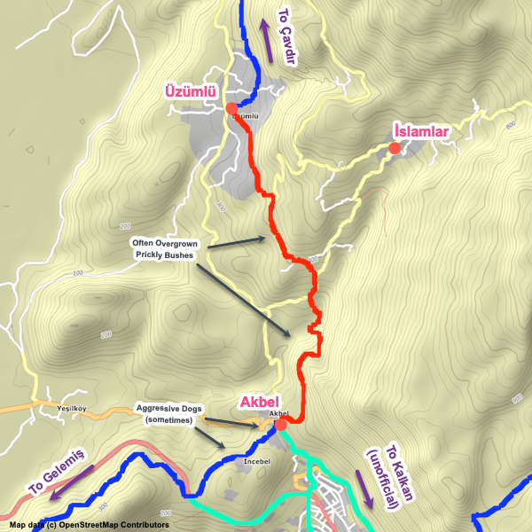
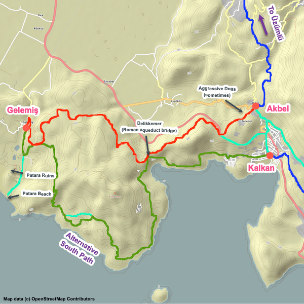
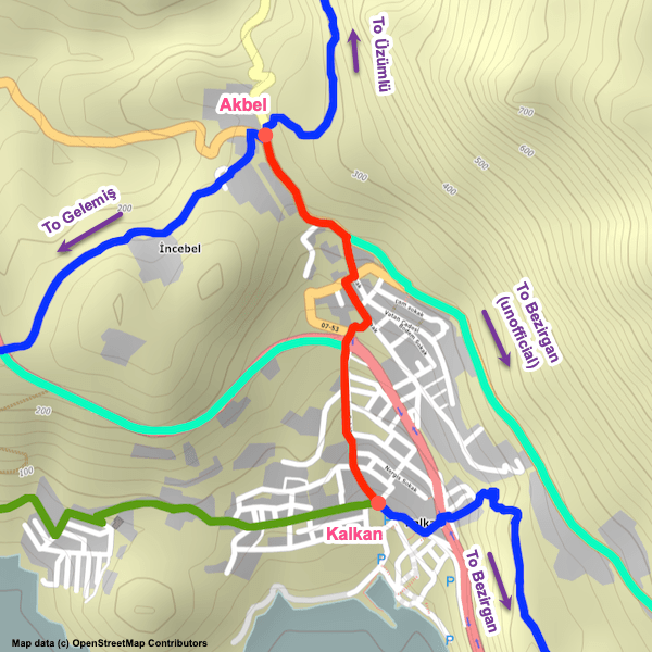
Wayfinding

  • At one point N of Akbel that’s a trail blockage due to new villa that completely blocks the trail. The way around it doesn’t seem to be clearly marked yet. We’ve updated our GPS track in that area based on reports / photos we’ve been sent.

Water

  • Water fountains are available at the endpoints and while passing through the outskirts of İslamlar.

Camping

  • There’s a couple of camping locations that we’re aware of, but in general the terrain is too rocky and uneven for camping along most of the section.

Amenities

  • A market is available in the outskirts of İslamlar.

Accommodations

Here’s what we’re currently tracking for this trail section:
  • Annotated map of Villa Cennet Bahcesi in Üzümlü
    Guesthouse
    Villa Cennet Bahcesi
    In Üzümlü
  • Annotated map of Villa Lapaz Esintisi in Üzümlü
    Guesthouse
    Villa Lapaz Esintisi
    In Üzümlü

Wild Camping Locations

Here are the wild camping locations that we’re currently tracking along this trail section:
  • Campsite between Üzümlü and Akbel
    Wild Campsite
    Campsite
    Between Üzümlü and Akbel
  • Campsite behind mosque in Akbel
    Wild Campsite
    Campsite Behind Mosque
    In Akbel

Water Sources

Here are the water sources that we’re currently tracking along this trail section or at either endpoint:
  • Fountain by mosque in Üzümlü
    Water Source
    Fountain by Mosque
    In Üzümlü
  • Fountain in Üzümlü
    Water Source
    Fountain
    In Üzümlü
  • Water source between Üzümlü and Akbel
    Water Source
    Water Source
    Between Üzümlü and Akbel
  • Map of Water Fountain in Akbel [279] [CE2673]
    Water Source
    Water Fountain
    In Akbel

Where to Next?

From Akbel:

  • Map showing the Lycian Way between Akbel and Gelemiş via the northern path.
    Main Path
    Akbel – Gelemiş (Patara Village)
    Distance
    14.5 km / 9.0 mi
    Ascent
    355 m / 1,165 ft
    Descent
    595 m / 1,952 ft
    Est. Duration
    5.2
    Attractive section linking the villages of Akbel and Gelemiş (aka Patara Village), passing by the extremely impressive Delikkemer Roman aqueduct and finishing close to the excellent Patara ruins and its nearby beach.
  • Map showing the Lycian Way between Akbel and Kalkan via an unofficial path along roads.
    Bypass Path
    Akbel – Kalkan
    Distance
    2.0 km / 1.2 mi
    Ascent
    0 m / 0 ft
    Descent
    200 m / 656 ft
    Est. Duration
    0.75
    Off-route (unofficial) shortcut along paved roads connecting Akbel to Kalkan. Useful if you are tight on time or simply want to cut the entire Gelemiş / Patara loop from your hike.

From Üzümlü:

  • Map showing the Lycian Way between Çavdır and Üzümlü.
    Main Path
    Çavdır – Üzümlü
    Distance
    9.2 km / 5.7 mi
    Ascent
    485 m / 1,591 ft
    Descent
    280 m / 919 ft
    Est. Duration
    3.6
    Winding path through the northern part of the delta, linking Çavdır and Üzümlü. Mostly on hillsides with much of it directly on the remains of a Roman aqueduct.

Pretty Pictures

Sometimes nothing beats a good photo. Or even a bad photo! If you’d like to share some or all of your photo collection with the Trekopedia community, contact us at photos@trekopedia.com and we can arrange a transfer of them. And thanks!
All photos are copyright by their respective owners and are used with permission.
  • Rocky path with blaze visible between Üzümlü - Akbel
    Rocky path with blaze visible between Üzümlü and Akbel
    Photo by 
    Susanne Rieder
     – 
    Nov 2022

How You Can Help

Trail research is never actually done. Here’s some of what we’re looking for:
✅   More photos! Ideally with geo-location information in the metadata. In addition to using some photos on Trekopedia, we add them to our internal reference database which significantly helps us with trail research. The more photos, the better! If you are willing to share your collection with us, we’d be incredibly grateful. Let us know and we’ll arrange a transfer.

✅   Points of interest. Help us identify (and geo-locate) accommodations, attractions, restaurants, markets, trail waypoints, confusing or problematic junctions, difficult or hazardous places, water sources, and so on. 

✅   Tips & recommendations. Share your thoughts with other hikers.
In addition to the above, please see this article for information on more general ways you can help. Thanks!
0 0 votes
Article Rating
Subscribe
Notify of
guest
0 Comments
Inline Feedbacks
View all comments
0
Would love your thoughts, please comment.x
()
x