


Essentials
Metrics
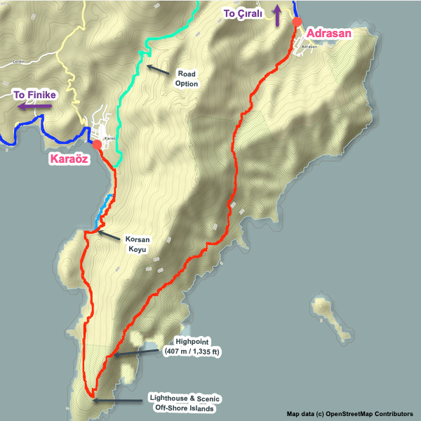
Select the tab below corresponding to the direction you plan to walk.
Towards Karaöz:
Towards Finike:


Handy Things to Know
The following notes are gathered from our own experiences and from feedback sent to us by other hikers. Let us know how we can improve these notes – and thanks!
Water
- Water is available in multiple places, especially towards the E end of this section.
Highlights
- The Gagai Ruins are at the top of a hill near Karaöz, slightly off of the Lycian Way (visible from the trail).
Route Planning
- Many people find this to be a boring stretch and skip it entirely. It is easy to get a dolmuş between Finike and Karaöz or your guesthouse operator can arrange a private ride. The main drawbacks to this stretch are that it is very exposed, you are walking on asphalt most of the way, there is a lot of traffic on the road right beside you (especially tractors), and there are no interesting attractions.
Accommodations
- There’s a small number of accommodation options along the way if you want to split this section in two. Plus, of course, there’s a selection at both endpoints.
Camping
- We’re not aware of any wild camping options.
Amenities
- There’s a couple of markets if you need to top-up your supplies.
Attractions & Highlights
Notable highlights along the trail and at either endpoint include:
Accommodations
Here’s what we’re currently tracking for this trail section:
Wild Camping Locations
Here are the wild camping locations that we’re currently tracking along this trail section:
Water Sources
Here are the water sources that we’re currently tracking along this trail section or at either endpoint:

Pretty Pictures
Sometimes nothing beats a good photo. Or even a bad photo! If you’d like to share some or all of your photo collection with the Trekopedia community, contact us at photos@trekopedia.com and we can arrange a transfer of them. And thanks!
All photos are copyright by their respective owners and are used with permission.


How You Can Help
Trail research is never actually done. Here’s some of what we’re looking for:
✅ More photos! Ideally with geo-location information in the metadata. In addition to using some photos on Trekopedia, we add them to our internal reference database which significantly helps us with trail research. The more photos, the better! If you are willing to share your collection with us, we’d be incredibly grateful. Let us know and we’ll arrange a transfer.
✅ Points of interest. Help us identify (and geo-locate) accommodations, attractions, restaurants, markets, trail waypoints, confusing or problematic junctions, difficult or hazardous places, water sources, and so on.
✅ Tips & recommendations. Share your thoughts with other hikers.
✅ Points of interest. Help us identify (and geo-locate) accommodations, attractions, restaurants, markets, trail waypoints, confusing or problematic junctions, difficult or hazardous places, water sources, and so on.
✅ Tips & recommendations. Share your thoughts with other hikers.
In addition to the above, please see this article for information on more general ways you can help. Thanks!