Main Path
Hısarçandır – Çitdibi
ID: 
59

Rugged, winding section between Hısarçandır and Çitdibi, passing through the mountains with some moderately steep portions.

View of Çitdibi coming from Hısarçandır
Image credit:  
Ambling Trails
, All rights reserved

Essentials

Hısarçandır (village)
Çitdibi (village)
SE–NW section with Çitdibi to the NW, with the path itself bulging a bit to the W / SW.
This section is a descent off of one mountain, a riverbed crossing, and an ascent up the flank of another mountain. The SE side descends towards the W / NW at a relatively modest average slope of 10.5% with some 15%+ short bits thrown in just to keep things interesting. The NW side of the section ascends towards the NW at an average slope of about 13% albeit with some much steeper short stretches (including a bit at about 28% grade). Some of the slope on the immediate N side of the riverbed is particularly steep.
Follows a mix of roads and trails. There are rugged portions where you’ll need to watch your footing and some areas where the path is frequently a bit over-grown.
Way-finding is very hit-or-miss along this section, depending on how recently the trail maintenance people have refreshed the blazes and how thorough they were at it.

Metrics

Select the tab below corresponding to the direction you plan to walk.
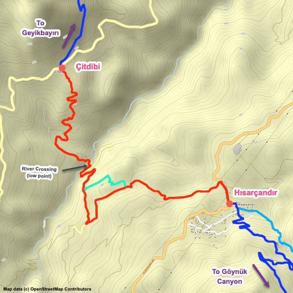
Towards Çitdibi:
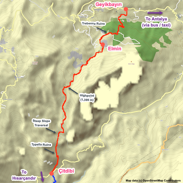
Towards Hısarçandır:
8.0 km / 5.0 mi
Distance
398 m / 1,306 ft
Ascent
481 m / 1,578 ft
Descent
~3.5 hrs
Duration
Elevation chart.
8.0 km / 5.0 mi
Distance
481 m / 1,578 ft
Ascent
398 m / 1,306 ft
Descent
~3.5 hrs
Duration
Elevation chart.

Handy Things to Know

The following notes are gathered from our own experiences and from feedback sent to us by other hikers. Let us know how we can improve these notes – and thanks!

Water

  • There’s a fairly reliably spring water source not far from Hısarçandır.

Tips

  • This is one of the two ‘new’ sections added in 2014 to the eastern end of the trail.

Camping

  • Several good wild camping locations are available. We have the best ones included in our GPS waypoints file.

Accommodations

Here’s what we’re currently tracking for this trail section:
  • Annotated map of Tuncay Yerdelen's House in Hısarçandır
    Guesthouse
    Tuncay Yerdelen’s House
    In Hısarçandır

Wild Camping Locations

Here are the wild camping locations that we’re currently tracking along this trail section:
  • Campsite between Hısarçandır and Çitdibi
    Wild Campsite
    Campsite
    Between Hısarçandır and Çitdibi

Water Sources

Here are the water sources that we’re currently tracking along this trail section or at either endpoint:
  • Fountain at the Mosque in Hısarçandır
    Water Source
    Fountain at the Mosque
    In Hısarçandır
  • Spring Water Between Hısarçandır and Çitdibi
    Water Source
    Spring Water
    Between Hısarçandır and Çitdibi

Where to Next?

From Çitdibi:

  • Map of the Lycian Way between Çitdibi and Geyikbayırı.
    Main Path
    Çitdibi – Geyikbayırı
    Distance
    15.1 km / 9.4 mi
    Ascent
    949 m / 3,114 ft
    Descent
    1,305 m / 4,281 ft
    Est. Duration
    8.0
    This is the eastern end of the Lycian Way. It’s almost a continual climb or descent, with some portions moderately steep. Much of this section is rugged, with uneven surfaces and sharp rocks.

From Hısarçandır:

  • Map of the Lycian Way between Göynük Canyon and Hısarçandır.
    Main Path
    Göynük Canyon – Hısarçandır
    Distance
    19.3 km / 12.0 mi
    Ascent
    1,795 m / 5,889 ft
    Descent
    1,000 m / 3,281 ft
    Est. Duration
    10.0
    Long section linking Göynük Canyon with the village of Hısarçandır. This used to be the first or last section of the Lycian Way (depending on which way you were walking) until it was extended in early 2014.

Pretty Pictures

Sometimes nothing beats a good photo. Or even a bad photo! If you’d like to share some or all of your photo collection with the Trekopedia community, contact us at photos@trekopedia.com and we can arrange a transfer of them. And thanks!
All photos are copyright by their respective owners and are used with permission.
  • View of Çitdibi coming from Hısarçandır
    View of Çitdibi coming from Hısarçandır
    Photo by 
    Ambling Trails
     – 
    Fall 2022

How You Can Help

Trail research is never actually done. Here’s some of what we’re looking for:
✅   More photos! Ideally with geo-location information in the metadata. In addition to using some photos on Trekopedia, we add them to our internal reference database which significantly helps us with trail research. The more photos, the better! If you are willing to share your collection with us, we’d be incredibly grateful. Let us know and we’ll arrange a transfer.

✅   Points of interest. Help us identify (and geo-locate) accommodations, attractions, restaurants, markets, trail waypoints, confusing or problematic junctions, difficult or hazardous places, water sources, and so on. 

✅   Tips & recommendations. Share your thoughts with other hikers.
In addition to the above, please see this article for information on more general ways you can help. Thanks!
0 0 votes
Article Rating
Subscribe
Notify of
guest
0 Comments
Inline Feedbacks
View all comments
0
Would love your thoughts, please comment.x
()
x