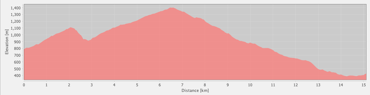
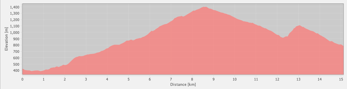
Main Path
Çitdibi – Geyikbayırı
ID: 
60

This is the eastern end of the Lycian Way. It’s almost a continual climb or descent, with some portions moderately steep. Much of this section is rugged, with uneven surfaces and sharp rocks.

Sheer cliffs at Geyikbayırı with a climber holding on for dear life
Image credit:  
Łukasz Ostojski
, All rights reserved

Essentials

Çitdibi (village)
Geyikbayırı (village)
SSW–NNE section with Geyikbayırı to the NNE. Passes through the hamlet of Elmin.
Largely an ascent and descent along the slopes of Sivri Dağ, through a national park of the same name. On the S side of the mountain the slope generally ascends towards the N at grades ranging from 13% to 16%. There’s also a descending portion on the S side of the mountain which is quite steep at about 31% grade. On the N side of the mountain, the slope averages 14.5% with many sections at 17.5%+ and a few at 25%+. Your legs are going to get a workout!
Follows a mix of wide tracks / forest roads and mostly decent-quality mountain footpaths. However, the footpaths are often rugged, with uneven surfaces and sharp rocks in places.
Way-markings are often inconsistent or missing through parts of this section. Look for handy cairns built by other hikers.

Metrics

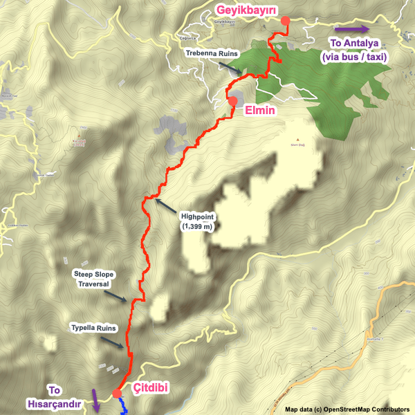
Select the tab below corresponding to the direction you plan to walk.
Towards Geyikbayırı:
Towards Çitdibi:
15.1 km / 9.4 mi
Distance
949 m / 3,114 ft
Ascent
1,305 m / 4,281 ft
Descent
~8.0 hrs
Duration
Elevation chart.
15.1 km / 9.4 mi
Distance
1,305 m / 4,281 ft
Ascent
949 m / 3,114 ft
Descent
~8.0 hrs
Duration
Elevation chart.

Handy Things to Know

The following notes are gathered from our own experiences and from feedback sent to us by other hikers. Let us know how we can improve these notes – and thanks!

Wayfinding

  • This can be a frustrating section due to the poor state of the way-markings. Hopefully the maintenance team will soon give everything a thorough overhaul – it needs it!
  • Give yourself extra time on this section as you’ll probably go astray a least once. Check your position against our GPS tracks frequently.

Water

  • Multiple water sources are available, several of which are fairly reliable most of the year.

Highlights

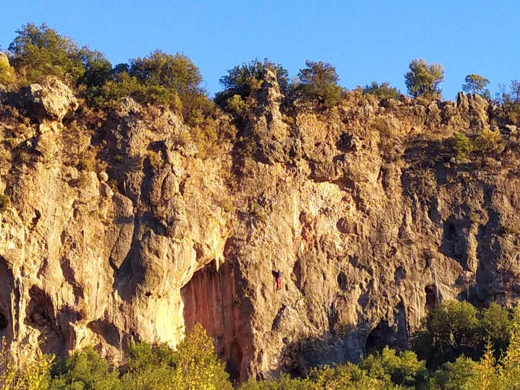
  • Passes by the ruins of the Lycian communities of Typella and Trebenna. There isn’t much there compared to what you’ll see elsewhere along the Lycian Way but they’re still interesting. We’ve had people tell us Trebenna was a good place for camping.

Route Planning

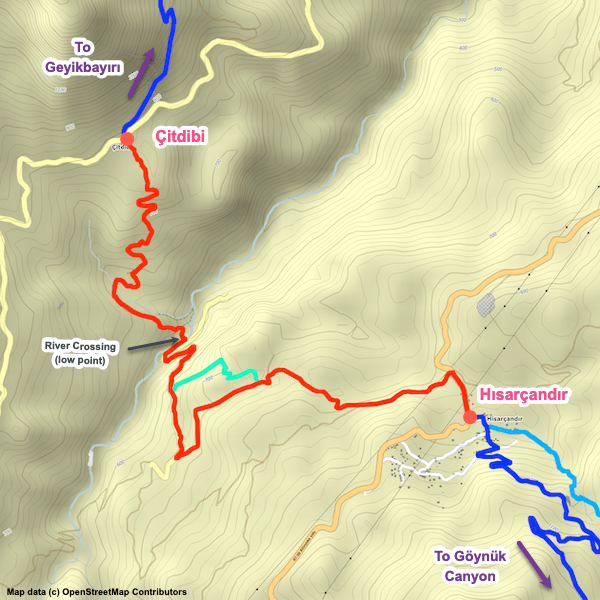
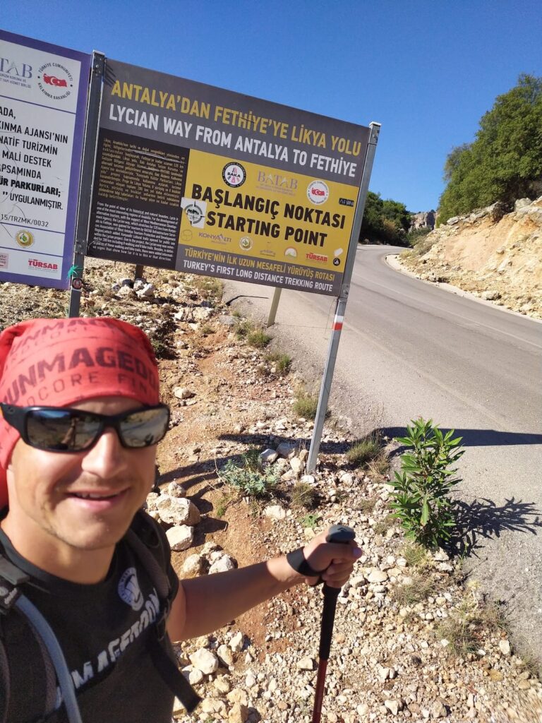
  • We mark two different trailheads for the Geyikbayırı endpoint of this section, one by Josito Camping and one slightly further away by the main road. There’s ‘Start’ signage at both trailheads. Our understanding, is that the Josito trailhead is the official eastern endpoint of the Lycian Way.
  • We include both endpoints in our GPS waypoints file and our GPS tracks continue all the way to the main road, so you can treat whichever one you prefer as your endpoint.

Camping

  • There are several decent places for wild camping.
  • There are also multiple commercial campgrounds in Geyikbayırı.

Attractions & Highlights

Notable highlights along the trail and at either endpoint include:
  • Trebenna Ruins Between Çitdibi & Geyikbayırı
    Historical Site
    Trebenna Ruins
    Between Çitdibi & Geyikbayırı

Accommodations

Here’s what we’re currently tracking for this trail section:
  • Annotated map of Josito Camping in Geyikbayırı
    Commercial Campground
    Josito Camping
    In Geyikbayırı
  • Annotated map of Kezban's Guesthouse & Camping in Geyikbayırı
    Guesthouse
    Kezban’s Guesthouse & Camping
    In Geyikbayırı

Wild Camping Locations

Here are the wild camping locations that we’re currently tracking along this trail section:
  • Campsite between Çitdibi and Geyikbayırı
    Wild Campsite
    Campsite
    Between Çitdibi and Geyikbayırı
  • Campsite between Çitdibi and Geyikbayırı
    Wild Campsite
    Campsite
    Between Çitdibi and Geyikbayırı

Water Sources

Here are the water sources that we’re currently tracking along this trail section or at either endpoint:
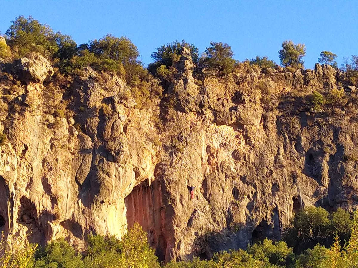
  • Water Source Between Çitdibi and Geyikbayırı
    Water Source
    Water Source
    Between Çitdibi and Geyikbayırı
  • Water Source Between Çitdibi and Geyikbayırı
    Water Source
    Water Source
    Between Çitdibi and Geyikbayırı
  • Water Source Between Çitdibi and Geyikbayırı
    Water Source
    Water Source
    Between Çitdibi and Geyikbayırı
  • Water Source Between Çitdibi and Geyikbayırı
    Water Source
    Water Source
    Between Çitdibi and Geyikbayırı
  • Off-route Water Source Between Çitdibi and Geyikbayırı
    Water Source
    Off-route Water Source
    Between Çitdibi and Geyikbayırı
  • Water Source Between Çitdibi and Geyikbayırı
    Water Source
    Water Source
    Between Çitdibi and Geyikbayırı

Where to Next?

From Geyikbayırı:

Congratulations! You’re done. Time to go home or maybe explore some other parts of Turkey (the Carian Trail, St. Paul’s Trail, and Cappadocia are all highly recommended).


Safe travels! We hope our website has been helpful to you. If you have suggestions on how we can improve things, please let us know.


A small request: We’d love to be able to use your photo collection in our project. It helps with our trail research (sort of our own version of Google Street View) and, of course, gives us more photos to use on our website. If you want to share them with us (for the Lycian Way or any long-distance trail), let us know and we’ll arrange a transfer. And thanks!

From Çitdibi:

  • Map of the Lycian Way between Hısarçandır and Çitdibi.
    Main Path
    Hısarçandır – Çitdibi
    Distance
    8.0 km / 5.0 mi
    Ascent
    398 m / 1,306 ft
    Descent
    481 m / 1,578 ft
    Est. Duration
    3.5
    Rugged, winding section between Hısarçandır and Çitdibi, passing through the mountains with some moderately steep portions.

Pretty Pictures

Sometimes nothing beats a good photo. Or even a bad photo! If you’d like to share some or all of your photo collection with the Trekopedia community, contact us at photos@trekopedia.com and we can arrange a transfer of them. And thanks!
All photos are copyright by their respective owners and are used with permission.
  • Endpoint signage at main road (old endpoint) in Geyikbayırı
    Hiker at endpoint signage at main road (old endpoint) in Geyikbayırı
    Photo by 
    Łukasz Ostojski
     – 
    Fall 2021
  • Endpoint signage by Josito Camping in Geyikbayırı
    Hiker at endpoint signage by Josito Camping in Geyikbayırı
    Photo by 
    Łukasz Ostojski
     – 
    Fall 2021
  • Sheer cliffs at Geyikbayırı with a climber holding on for dear life
    Sheer cliffs at Geyikbayırı with a climber holding on for dear life
    Photo by 
    Łukasz Ostojski
     – 
    Fall 2021

How You Can Help

Trail research is never actually done. Here’s some of what we’re looking for:
✅   More photos! Ideally with geo-location information in the metadata. In addition to using some photos on Trekopedia, we add them to our internal reference database which significantly helps us with trail research. The more photos, the better! If you are willing to share your collection with us, we’d be incredibly grateful. Let us know and we’ll arrange a transfer.

✅   Points of interest. Help us identify (and geo-locate) accommodations, attractions, restaurants, markets, trail waypoints, confusing or problematic junctions, difficult or hazardous places, water sources, and so on. 

✅   Tips & recommendations. Share your thoughts with other hikers.
In addition to the above, please see this article for information on more general ways you can help. Thanks!
0 0 votes
Article Rating
Subscribe
Notify of
guest
0 Comments
Inline Feedbacks
View all comments
0
Would love your thoughts, please comment.x
()
x