Alternate Path
Tekirova – Kuzdere
ID: 
52

Winding section that is part of the coastal variant between Çıralı and Göynük Yayla, though most of it is actually inland.

Hiker looking at aqueduct at Phaselis Ruins
Image credit:  
T Roszkowski
, All rights reserved

Essentials

Tekirova (town)
Kuzdere (village)
Winding section that is S–N overall but with a significant bulge to the E. Kuzdere is to the N.
The area N of the main road D400 is an ascent / descent of a modest-sized hill with about a 10% slope on the S side and 14% on the N side. On either side of the hill, and along the coast between Tekirova and the Phaselis ruins, it is relatively flat with only small hills to contend with (though some, while short, are steep with up to a 20% grade).
From Tekirova to the D400 underpass (N of the Phaselis ruins)  the route follows good-quality woodland trails, beaches, and quiet tracks / roads. N of D400, the terrain is rugged in places, following a mix of quiet rural roads and mountain footpaths.
Way-finding is moderately good along this section, though some junctions N of D400 can potentially be confusing.

Metrics

Select the tab below corresponding to the direction you plan to walk.
Towards Kuzdere:
Towards Tekirova:
18.5 km / 11.5 mi
Distance
666 m / 2,185 ft
Ascent
623 m / 2,044 ft
Descent
~6.75 hrs hrs
Duration
Elevation chart.
18.5 km / 11.5 mi
Distance
623 m / 2,044 ft
Ascent
666 m / 2,185 ft
Descent
~6.75 hrs hrs
Duration
Elevation chart.

Handy Things to Know

The following notes are gathered from our own experiences and from feedback sent to us by other hikers. Let us know how we can improve these notes – and thanks!

Water

  • Water and public toilets are available at Phaselis Beach (slightly inland from the Lycian Way path).
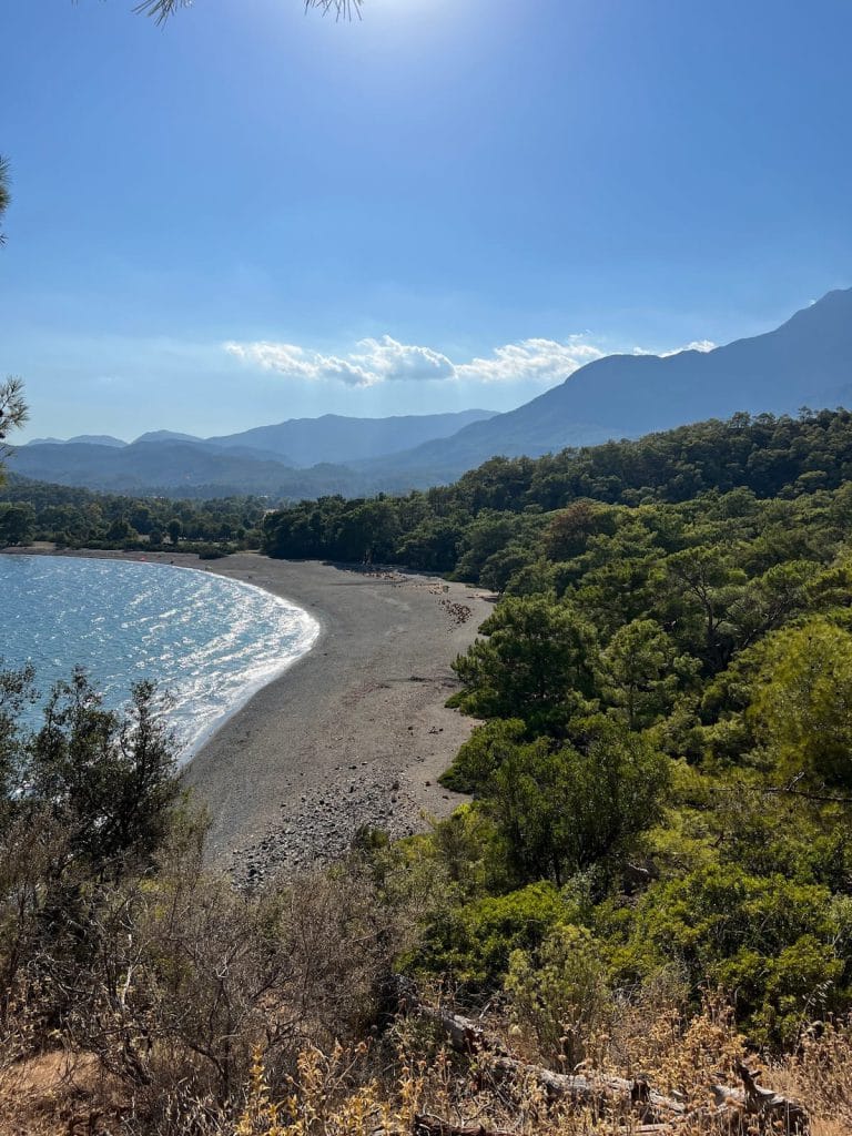
Highlights

  • The ruins are interesting and worth some time. The aqueduct is particularly notable.
  • The beaches are in a sheltered cove and a good spot for a break (and maybe a little dip…).

Tips

  • From D400, it is possible to detour into the nearby town of Çamyuva. It’s within modest walking distance, though you can easily wave down a dolmuş (or hitchhike) once you get to the main road (D400).

Route Planning

  • There’s a secondary (unofficial) option for much of the stretch N of D400 that follows roads instead of mountain footpaths. This secondary option used to be part of the official route before re-routing was done. It’s shorter and might be worth considering in bad weather. We include it in our GPS tracks.

Camping

  • If you are camping, there are good camping spots along the beaches near the Phaselis ruins. N of D400 there are multiple decent camping options.

Amenities

  • Snacks / beverages are often available at the Phaselis ruins.

Attractions & Highlights

Notable highlights along the trail and at either endpoint include:

Accommodations

Here’s what we’re currently tracking for this trail section:
  • Annotated map of Güvenpark Residence & Hotel in Tekirova
    Hotel
    Güvenpark Residence & Hotel
    In Tekirova
  • Annotated map of Sundance Nature Camping Near Tekirova
    Camping / Bungalows
    Sundance Nature Camping
    On the northeastern edge of Tekirova
  • Annotated map of Green Valley Hotel in Kuzdere
    Hotel
    Green Valley Hotel
    In Kuzdere

Wild Camping Locations

Here are the wild camping locations that we’re currently tracking along this trail section:
  • Campsite Between Tekirova and Phaselis Ruins
    Wild Campsite
    Campsite
    Between Tekirova and Phaselis Ruins
  • Campsite Between Tekirova and Phaselis Ruins
    Wild Campsite
    Campsite
    Between Tekirova and Phaselis Ruins

Water Sources

Here are the water sources that we’re currently tracking along this trail section or at either endpoint:
  • Fountain & WC Between Tekirova and Phaselis Ruins
    Water Source
    Fountain & WC
    Between Tekirova and Phaselis Ruins

Where to Next?

From Kuzdere:

  • Map of the Lycian Way between Kuzdere and Göynük Yayla.
    Alternate Path
    Kuzdere – Göynük Yayla
    Distance
    17.6 km / 10.9 mi
    Ascent
    1,341 m / 4,400 ft
    Descent
    560 m / 1,837 ft
    Est. Duration
    7.75
    Beautiful mountain section that gives the legs a good workout. In addition to outstanding scenery, there’s a Roman bridge to cross along the way. This is part of the ‘coastal’ variant between Çıralı & Göynük Yayla (though this portion is entirely inland rather than on the coast).

From Tekirova:

  • Map of the Lycian Way between Çıralı and Tekirova.
    Alternate Path
    Çıralı – Tekirova
    Distance
    21.8 km / 13.5 mi
    Ascent
    1,140 m / 3,741 ft
    Descent
    1,130 m / 3,708 ft
    Est. Duration
    9.5
    Long but attractive section that is part of the coastal route between Çıralı and Göynük Yayla.   Although this path runs along the coast (much of it via quiet forest roads), there are rugged hills and some steep portions. Has many nice viewpoints.

Pretty Pictures

Sometimes nothing beats a good photo. Or even a bad photo! If you’d like to share some or all of your photo collection with the Trekopedia community, contact us at photos@trekopedia.com and we can arrange a transfer of them. And thanks!
All photos are copyright by their respective owners and are used with permission.
  • Hadrian's Gate at Phaselis ruins
    Hadrian’s Gate at Phaselis ruins
    Photo by 
    Costin D.
     – 
    Fall 2022
  • Domitian's Agora at Phaselis ruins
    Domitian’s Agora at Phaselis ruins
    Photo by 
    Costin D.
     – 
    Fall 2022
  • Livestock on road departing Tekirova for Phaselis ruins
    Livestock on road departing Tekirova for Phaselis ruins
    Photo by 
    Anonymous
     – 
    Fall 2022
  • Coastal view from between Phaselis ruins and D400
    Coastal view from between Phaselis ruins and D400
    Photo by 
    Anonymous
     – 
    Fall 2022
  • On road at south edge of Kuzdere
    On road at south edge of Kuzdere
    Photo by 
    Anonymous
     – 
    Fall 2022
  • Signpost between Çamyuva and Kuzdere
    Signpost between Çamyuva and Kuzdere
    Photo by 
    Gina Russell
     – 
    Fall 2022
  • Hiker looking at aqueduct at Phaselis Ruins
    Hiker looking at aqueduct at Phaselis Ruins
    Photo by 
    T Roszkowski
     – 
    Spring 2022
  • Looking SW at beach from between Tekirova and Phaselis ruins
    Looking SW at beach from between Tekirova and Phaselis ruins
    Photo by 
    Costin D.
     – 
    Sept 2022

How You Can Help

Trail research is never actually done. Here’s some of what we’re looking for:
✅   More photos! Ideally with geo-location information in the metadata. In addition to using some photos on Trekopedia, we add them to our internal reference database which significantly helps us with trail research. The more photos, the better! If you are willing to share your collection with us, we’d be incredibly grateful. Let us know and we’ll arrange a transfer.

✅   Points of interest. Help us identify (and geo-locate) accommodations, attractions, restaurants, markets, trail waypoints, confusing or problematic junctions, difficult or hazardous places, water sources, and so on. 

✅   Tips & recommendations. Share your thoughts with other hikers.
In addition to the above, please see this article for information on more general ways you can help. Thanks!
0 0 votes
Article Rating
Subscribe
Notify of
guest
0 Comments
Inline Feedbacks
View all comments
0
Would love your thoughts, please comment.x
()
x