Alternate Path
Çıralı – Tekirova
ID: 
50

Long but attractive section that is part of the coastal route between Çıralı and Göynük Yayla.


Although this path runs along the coast (much of it via quiet forest roads), there are rugged hills and some steep portions. Has many nice viewpoints.

View of campsite between Çıralı and Tekirova.
Image credit:  
Alex Boatfield
, All rights reserved

Essentials

Çıralı (town)
Tekirova (town)
SW–NE section with Tekirova to the NE, that generally stays very close to the coastline.
Very hilly section with most of the hills small but often steep (18%+ in places). There’s one larger, moderately steep hill in the middle of the section, to the N of Maden Koyu where the path cuts slightly inland.
Follows a mix of generally decent-quality footpaths through woodlands / scrub and some quiet / peaceful forest tracks and roads. The NE portion near and in Tekirova is all on paved roads.
Way-finding is decent but not great with many junctions missing painted blazes or signposts. Make periodic checks of your position against our GPS tracks to ensure you are still on-route.

Metrics

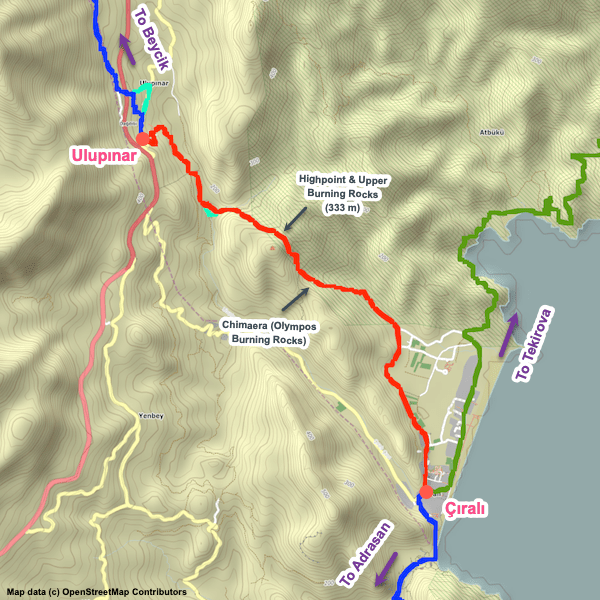
Select the tab below corresponding to the direction you plan to walk.
Towards Tekirova:
Towards Çıralı:
21.8 km / 13.5 mi
Distance
1,140 m / 3,741 ft
Ascent
1,130 m / 3,708 ft
Descent
~9.5 hrs
Duration
Elevation chart.
21.8 km / 13.5 mi
Distance
1,130 m / 3,708 ft
Ascent
1,140 m / 3,741 ft
Descent
~9.5 hrs
Duration
Elevation chart.

Handy Things to Know

The following notes are gathered from our own experiences and from feedback sent to us by other hikers. Let us know how we can improve these notes – and thanks!

Water

  • There are multiple water sources most of which are reliable for most of the year.

Highlights

  • The scenery is the highlight of this section, with both the every-changing coastline and the surrounding hills being quite attractive.

Route Planning

  • This section is part of the alternative coastal route to / from Göynük Yayla that bypasses the climb up Tahtalı Dağı. This alternate route is easier than the inland route and has a different mix of terrain / sights (such as going through the Phaselis ruins). For the inland route, follow Çıralı to Ulupınar.

Alerts / Hazards

  • During Jan / Feb or whenever there’s been a lot of rainfall you may need to ford a few streams along this section; nothing more than knee-deep, typically (and usually just ankle-deep).

Attractions & Highlights

Notable highlights along the trail and at either endpoint include:

Accommodations

Here’s what we’re currently tracking for this trail section:
  • Annotated map of Sheriff Olympos Pansiyon at Olympos Ruins
    Guesthouse
    Sheriff Olympos Pansiyon
    At Olympos Ruins
  • Annotated map of Bayram Tree Houses at Olympos Ruins
    Guesthouse
    Bayram Tree Houses
    At the Olympos Ruins
  • Annotated map of Olympos Lodge in Çıralı
    Guesthouse
    Olympos Lodge
    In Çıralı
  • Annotated map of Smile Butik Hotel in Çıralı
    Bungalows
    Smile Butik Hotel
    In Çıralı
  • Annotated map of Güvenpark Residence & Hotel in Tekirova
    Hotel
    Güvenpark Residence & Hotel
    In Tekirova
  • Annotated map of Sundance Nature Camping Near Tekirova
    Camping / Bungalows
    Sundance Nature Camping
    On the northeastern edge of Tekirova

Wild Camping Locations

Here are the wild camping locations that we’re currently tracking along this trail section:
  • Campsite Between Çıralı and Tekirova
    Wild Campsite
    Campsite
    Between Çıralı and Tekirova
  • Campsite between Çıralı and Tekirova
    Wild Campsite
    Campsite
    Between Çıralı and Tekirova

Water Sources

Here are the water sources that we’re currently tracking along this trail section or at either endpoint:
  • Fountain in Çıralı
    Water Source
    Fountain
    In Çıralı
  • Fountain in Çıralı
    Water Source
    Fountain
    In Çıralı
  • Hose between Çıralı and Tekirova
    Water Source
    Water Fountain
    Between Çıralı and Tekirova
  • Fountain between Çıralı and Tekirova
    Water Source
    Water Fountain
    Between Çıralı and Tekirova
  • Fountain Between Çıralı and Tekirova
    Water Source
    Fountain
    Between Çıralı and Tekirova
  • Fountain Between Çıralı and Tekirova
    Water Source
    Fountain
    Between Çıralı and Tekirova

Where to Next?

From Tekirova:

  • Map of the Lycian Way between Tekirova and Kuzdere.
    Alternate Path
    Tekirova – Kuzdere
    Distance
    18.5 km / 11.5 mi
    Ascent
    666 m / 2,185 ft
    Descent
    623 m / 2,044 ft
    Est. Duration
    6.75 hrs
    Winding section that is part of the coastal variant between Çıralı and Göynük Yayla, though most of it is actually inland.

From Çıralı:

  • Map of the Lycian Way between Adrasan and Çıralı.
    Main Path
    Adrasan – Çıralı
    Distance
    15.5 km / 9.6 mi
    Ascent
    910 m / 2,987 ft
    Descent
    908 m / 2,980 ft
    Est. Duration
    7.0
    Beautiful section between Adrasan and Çıralı traversing Musa Dağı (Mount Moses) and passing through the Olympos ruins.
  • Map of the Lycian Way between Çıralı and Ulupınar.
    Main Path
    Çıralı – Ulupınar
    Distance
    8.1 km / 5.0 mi
    Ascent
    559 m / 1,833 ft
    Descent
    289 m / 947 ft
    Est. Duration
    5.5
    Mountain section, passing the famous ‘burning rocks’ of the Chimaera. There’s an access fee for this zone. There are water falls / streams coming down the mountain that are cold and refreshing.

Pretty Pictures

Sometimes nothing beats a good photo. Or even a bad photo! If you’d like to share some or all of your photo collection with the Trekopedia community, contact us at photos@trekopedia.com and we can arrange a transfer of them. And thanks!
All photos are copyright by their respective owners and are used with permission.
  • View of campsite between Çıralı and Tekirova.
    Campsite in a pretty location between Çıralı and Tekirova
    Photo by 
    Alex Boatfield
     – 
    Sept 2022
  • Hiker on coast between Çıralı and Tekirova.
    Hiker on coast between Çıralı and Tekirova
    Photo by 
    Alex Boatfield
     – 
    Fall 2022
  • Beach on Maden Koyu at dusk between Çıralı and Tekirova.
    Beach view on Maden Koyu at dusk
    Photo by 
    Alex Boatfield
     – 
    Fall 2022
  • View towards SSE along Gelidonya's east coast.
    View towards SSE along Gelidonya’s east coast
    Photo by 
    Alex Boatfield
     – 
    Fall 2022
  • Looking south from the north edge of Çıralı beach.
    Looking south from the north edge of Çıralı beach
    Photo by 
    Alex Boatfield
     – 
    Fall 2022

How You Can Help

Trail research is never actually done. Here’s some of what we’re looking for:
✅   More photos! Ideally with geo-location information in the metadata. In addition to using some photos on Trekopedia, we add them to our internal reference database which significantly helps us with trail research. The more photos, the better! If you are willing to share your collection with us, we’d be incredibly grateful. Let us know and we’ll arrange a transfer.

✅   Points of interest. Help us identify (and geo-locate) accommodations, attractions, restaurants, markets, trail waypoints, confusing or problematic junctions, difficult or hazardous places, water sources, and so on. 

✅   Tips & recommendations. Share your thoughts with other hikers.
In addition to the above, please see this article for information on more general ways you can help. Thanks!
0 0 votes
Article Rating
Subscribe
Notify of
guest
0 Comments
Inline Feedbacks
View all comments
0
Would love your thoughts, please comment.x
()
x