Main Path
Çıralı – Ulupınar
ID: 
49

Mountain section, passing the famous ‘burning rocks’ of the Chimaera. There’s an access fee for this zone. There are water falls / streams coming down the mountain that are cold and refreshing.

View of Çıralı from near burning rocks
Image credit:  
Alex Boatfield
, All rights reserved

Essentials

Çıralı (town)
Ulupınar (village)
SE–NW section with Ulupınar to the NW.
The southernmost third (through Çıralı) is almost completely flat. The mid-section traverses a modest hill (~300 m / 985 ft elevation change on the S side; about half that on the N side) with fairly steep slopes of about 20% on the S side and about 17% on the N side. The northern part has a gentler slope, ascending towards the N, averaging about 10%.
The portions through the two endpoint communities are along roads / tracks. Between Çıralı and the burning flames is a good-quality, mostly wide path with steps built into it. From the burning flames to Ulupınar are woodland footpaths of mostly good quality.
Way-finding is generally good though there are places near the stream on the N side of the highpoint that can be confusing.

Metrics

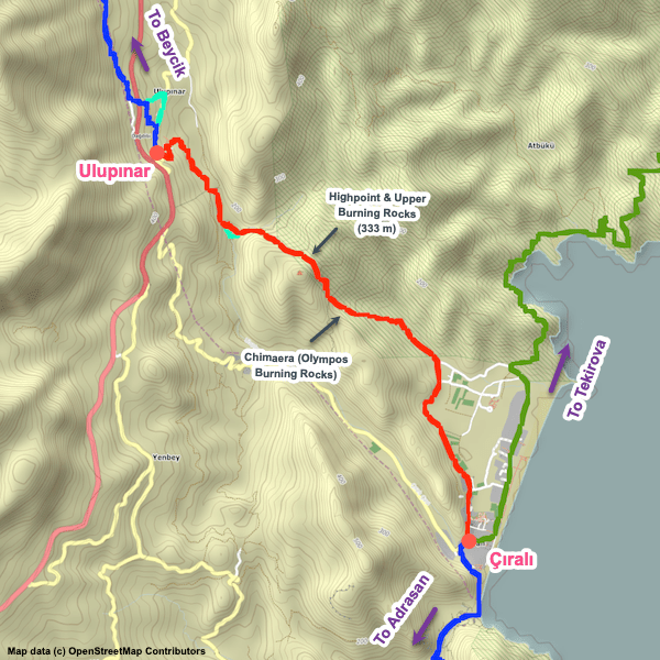
Select the tab below corresponding to the direction you plan to walk.
Towards Ulupınar:
Towards Çıralı:
8.1 km / 5.0 mi
Distance
559 m / 1,833 ft
Ascent
289 m / 947 ft
Descent
~5.5 hrs
Duration
Elevation chart.
8.1 km / 5.0 mi
Distance
289 m / 947 ft
Ascent
559 m / 1,833 ft
Descent
~5.5 hrs
Duration
Elevation chart.

Handy Things to Know

The following notes are gathered from our own experiences and from feedback sent to us by other hikers. Let us know how we can improve these notes – and thanks!

Water

  • There’s a water fountain at the Chimaera park entrance (along with toilets). There is also a mountain stream, though, if you have a filter with you.

Highlights

  • The burning flames are actually in two locations. The main one is lower on the slope but there is also a second location near the highpoint of the section.
  • By the main location you’ll also find the ruins of a Byzantium church.

Tips

  • There’s a stream that needs to be crossed where you might need to get your feet wet (in spring, it can be knee-high). There used to be a makeshift footbridge but it seems to be missing now.
  • There’s an access fee for this zone.
  • There are waterfalls / streams coming down the mountain that are cold and refreshing – and bracing if you decide to jump into one of the pools…
  • For something a bit different, consider doing a hike up to the flames in the evening (bring a good flashlight, of course, with some sort of headlamp being ideal). The site is interesting at any time but is spectacular once the sun sets. As an added bonus, the admission gate is unmanned at night so there’s no fee (from about 21:00, typically).

Route Planning

  • This is the first section of the interior / mountain route that involves climbing Tahtalı Dağı. There is an alternative route that follows the coast, bypassing Tahtalı Dağı, before cutting inland to meet up with the inland route shortly after Gedelme. For the alternative route, follow Çıralı to Tekirova. Both variants are nice though we’re partial to the interior route, for whatever that’s worth.

Camping

  • There are some decent wild camping spots near the highpoint.

Attractions & Highlights

Notable highlights along the trail and at either endpoint include:
  • Chimaera (Olympos Burning Rocks) between Çıralı and Ulupınar
    Landmark
    Chimaera (Olympos Burning Rocks)
    Between Çıralı and Ulupınar
  • Ruins of Byzantium Church Between Çıralı and Ulupınar
    Historical Site
    Ruins of Byzantium Church
    Between Çıralı and Ulupınar

Accommodations

Here’s what we’re currently tracking for this trail section:
  • Annotated map of Sheriff Olympos Pansiyon at Olympos Ruins
    Guesthouse
    Sheriff Olympos Pansiyon
    At Olympos Ruins
  • Annotated map of Bayram Tree Houses at Olympos Ruins
    Guesthouse
    Bayram Tree Houses
    At the Olympos Ruins
  • Annotated map of Olympos Lodge in Çıralı
    Guesthouse
    Olympos Lodge
    In Çıralı
  • Annotated map of Smile Butik Hotel in Çıralı
    Bungalows
    Smile Butik Hotel
    In Çıralı
  • Annotated map of Lycia Nature House (aka Lycia Hotel Ulupınar) in Ulupınar
    Hotel
    Lycia Nature House (aka Lycia Hotel Ulupınar)
    In Ulupınar

Wild Camping Locations

Here are the wild camping locations that we’re currently tracking along this trail section:
  • Campsite between Çıralı and Ulupınar
    Wild Campsite
    Campsite
    Between Çıralı and Ulupınar
  • Campsite between Çıralı and Ulupınar
    Wild Campsite
    Campsite
    Between Çıralı and Ulupınar

Water Sources

Here are the water sources that we’re currently tracking along this trail section or at either endpoint:
  • Fountain in Çıralı
    Water Source
    Fountain
    In Çıralı
  • Fountain in Çıralı
    Water Source
    Fountain
    In Çıralı
  • Fountain in Ulupınar
    Water Source
    Fountain
    in Ulupınar

Where to Next?

From Ulupınar:

  • Map of the Lycian Way between Ulupınar and Beycik.
    Main Path
    Ulupınar – Beycik
    Distance
    9.3 km / 5.8 mi
    Ascent
    818 m / 2,684 ft
    Descent
    256 m / 840 ft
    Est. Duration
    4.25
    Mountain section that is part of the ‘interior’ route between Çıralı and Göynük Yayla.

From Çıralı:

  • Map of the Lycian Way between Adrasan and Çıralı.
    Main Path
    Adrasan – Çıralı
    Distance
    15.5 km / 9.6 mi
    Ascent
    910 m / 2,987 ft
    Descent
    908 m / 2,980 ft
    Est. Duration
    7.0
    Beautiful section between Adrasan and Çıralı traversing Musa Dağı (Mount Moses) and passing through the Olympos ruins.
  • Map of the Lycian Way between Çıralı and Tekirova.
    Alternate Path
    Çıralı – Tekirova
    Distance
    21.8 km / 13.5 mi
    Ascent
    1,140 m / 3,741 ft
    Descent
    1,130 m / 3,708 ft
    Est. Duration
    9.5
    Long but attractive section that is part of the coastal route between Çıralı and Göynük Yayla.   Although this path runs along the coast (much of it via quiet forest roads), there are rugged hills and some steep portions. Has many nice viewpoints.

Pretty Pictures

Sometimes nothing beats a good photo. Or even a bad photo! If you’d like to share some or all of your photo collection with the Trekopedia community, contact us at photos@trekopedia.com and we can arrange a transfer of them. And thanks!
All photos are copyright by their respective owners and are used with permission.
  • View of Çıralı from near burning rocks
    View of Çıralı from near burning rocks
    Photo by 
    Alex Boatfield
     – 
    Fall 2022
  • Hiker taking a break on trail just north of burning rocks between Çıralı – Ulupınar.
    Hiker taking a break on trail just north of burning rocks
    Photo by 
    Costin D.
     – 
    Fall 2022
  • Crowd gathered at dusk at the burning rocks between Çıralı – Ulupınar.
    Crowd gathered at dusk at the burning rocks
    Photo by 
    Costin D.
     – 
    Fall 2022
  • Burning rocks
    Burning rocks
    Photo by 
    Irene Dijkmans
     – 
    Fall 2022
  • Burning rocks above Çıralı
    Burning rocks above Çıralı
    Photo by 
    Łukasz Ostojski
     – 
    Fall 2021

How You Can Help

Trail research is never actually done. Here’s some of what we’re looking for:
✅   More photos! Ideally with geo-location information in the metadata. In addition to using some photos on Trekopedia, we add them to our internal reference database which significantly helps us with trail research. The more photos, the better! If you are willing to share your collection with us, we’d be incredibly grateful. Let us know and we’ll arrange a transfer.

✅   Points of interest. Help us identify (and geo-locate) accommodations, attractions, restaurants, markets, trail waypoints, confusing or problematic junctions, difficult or hazardous places, water sources, and so on. 

✅   Tips & recommendations. Share your thoughts with other hikers.
In addition to the above, please see this article for information on more general ways you can help. Thanks!
0 0 votes
Article Rating
Subscribe
Notify of
guest
0 Comments
Inline Feedbacks
View all comments
0
Would love your thoughts, please comment.x
()
x