Main Path
Kalkan – Bezirgan
ID: 
30

Steep, sometimes rugged, sometimes confusing section linking the town of Kalkan with the mountain village of Bezirgan.

Nice view towards the coast from partway up the ascent to Bezirgan.
Image credit:  
Anonymous
, All rights reserved

Essentials

Kalkan (town)
Bezirgan (village)
WSW–ENE section overall, but with most of the section involving a large bend to the S. Kalkan is at the W end and Bezirgan is on a mountain plateau to the E.
Flat-ish at both ends, though most of the section is at a consistently steep slope of about 15%, ascending towards Bezirgan. Overall, there is about 800 m / 2,625 ft of elevation change on this section, so bring plenty of water and be ready to put those legs to work.
Many parts of the trail are rocky and sometimes have scree. Watch your footing. Some stretches, especially between Kalkan and the Ottoman cistern, are often overgrown with prickly bushes that can play havoc with your legs and arms.
The stretch between Kalkan and the Ottoman cistern often poorly way-marked and can be very hard to follow. The rest of the section is well-marked and shouldn’t be a problem.

Metrics

Select the tab below corresponding to the direction you plan to walk.
Towards Bezirgan:
Towards Kalkan:
10.3 km / 6.4 mi
Distance
845 m / 2,772 ft
Ascent
160 m / 525 ft
Descent
~4.3 hrs
Duration
Elevation chart.
10.3 km / 6.4 mi
Distance
160 m / 525 ft
Ascent
845 m / 2,772 ft
Descent
~4.3 hrs
Duration
Elevation chart.

Handy Things to Know

The following notes are gathered from our own experiences and from feedback sent to us by other hikers. Let us know how we can improve these notes – and thanks!

Wayfinding

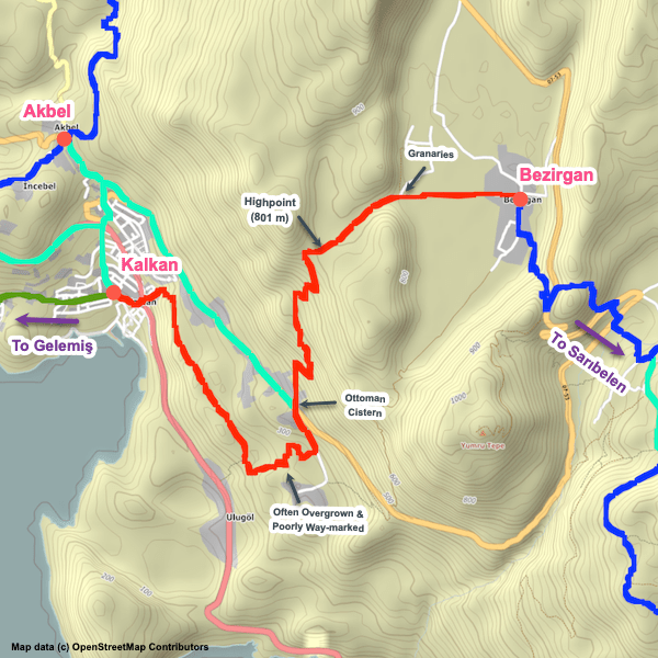
  • It’s not unusual for hikers to get lost on the portion between Kalkan and the road to its north with the Ottoman cistern. Make periodic checks of your location against our GPS tracks to verify that you are on-route.

Water

  • There are several water sources but many of them aren’t reliable (though the ones near Bezirgan tend to be dependable).

Highlights

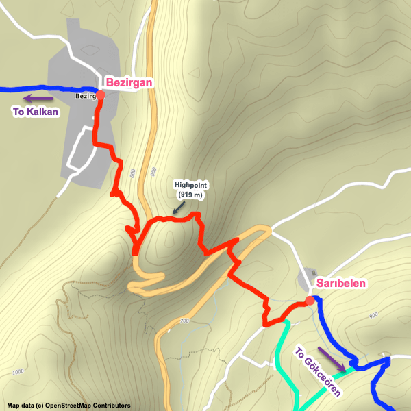
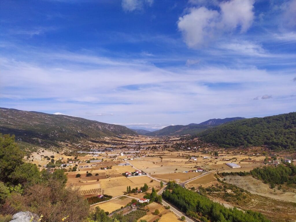
  • Great views! If you are ascending towards Bezirgan, don’t forget to look back periodically for the excellent coastal / bay views – as you ascend, the perspective changes.
  • The granaries on the western edge of Bezirgan are attractive and in a scenic location.

Tips

  • Our thanks to Olivier of Mozaik pansiyon in Sarıbelen for graciously taking the time to record for us the new track near Kalkan.

Route Planning

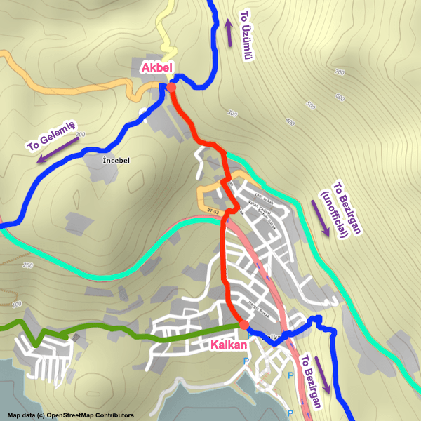
  • A popular variation on this section is to skip the portion near Kalkan by following quiet roads via the SE edge of Akbel instead. The distance is about the same (slightly shorter by road) but much faster and easier. The road option then merges with the official path at an Ottoman cistern at the base of the main off-road ascent to Bezirgan. Dolmuş service passes by the cistern if you don’t want to walk up the road (catch the dolmuş at Kalkan’s bus terminal).

Attractions & Highlights

Notable highlights along the trail and at either endpoint include:
  • Historic Granaries West of Bezirgan
    Historical Site
    Historic Granaries
    In Bezirgan

Accommodations

Here’s what we’re currently tracking for this trail section, including at the endpoints:
  • Annotated map of White House Pension in Kalkan
    Guesthouse
    White House Pension
    In Kalkan
  • Annotated map for Courtyard Hotel Kalkan in Kalkan
    Hotel
    Courtyard Hotel Kalkan
    In Kalkan
  • Annotated map of Gül Pansiyon in Kalkan
    Guesthouse
    Gül Pansiyon
    In Kalkan
  • Annotated map of Kleo Pension in Kalkan
    Guesthouse
    Kleo Pension
    In Kalkan
  • Annotated map of Neruda Pansiyon in Kalkan
    Guesthouse
    Neruda Pansiyon
    In Kalkan
  • Annotated map of Old Town Hotel Kalkan in Kalkan
    Hotel
    Old Town Hotel Kalkan
    In Kalkan
  • Annotated map of Rhapsody Hotel in Kalkan
    Hotel
    Rhapsody Hotel
    In Kalkan
  • Annotated map of Türk Evi (Hotel) in Kalkan
    Hotel
    Türk Evi (Hotel)
    In Kalkan
  • Annotated map of Erol's Apart in Bezirgan
    Guesthouse
    Erol’s Apart
    In Bezirgaqn
  • Annotated map of Owlsland (Pension) in Bezirgan
    Guesthouse
    Owlsland (Pension)
    Bezirgan

Wild Camping Locations

Here are the wild camping locations that we’re currently tracking along this trail section:
  • Campsite between Kalkan and Bezirgan
    Wild Campsite
    Campsite
    Between Kalkan and Bezirgan
  • Campsite between Kalkan and Bezirgan
    Wild Campsite
    Campsite
    Between Kalkan and Bezirgan

Water Sources

Here are the water sources that we’re currently tracking along this trail section or at either endpoint:
  • Fountain by mosque in Kalkan
    Water Source
    Fountain by Mosque
    In Kalkan
  • Water dispenser between Kalkan and Bezirgan
    Water Source
    Water Dispenser
    Between Kalkan and Bezirgan
  • Cistern between Kalkan and Bezirgan
    Water Source
    Cistern
    Between Kalkan and Bezirgan
  • Water source between Kalkan and Bezirgan
    Water Source
    Cistern
    Between Kalkan and Bezirgan
  • Cistern between Kalkan and Bezirgan
    Water Source
    Cistern
    Between Kalkan and Bezirgan
  • Water source between Kalkan and Bezirgan
    Water Source
    Well
    Between Kalkan and Bezirgan
  • Map of Water Fountain on Entrance to Bezirgan [282] [CE1710]
    Water Source
    Water Fountain
    In Bezirgan
  • Water source at western edge of Bezirgan
    Water Source
    Fountain
    Between Kalkan & Bezirgan
  • Water source and rest area in Bezirgan
    Water Source
    Water Source & Rest Area
    In Bezirgan

Where to Next?

From Bezirgan:

  • Map of the Lycian Way between Bezirgan and Sarıbelen.
    Main Path
    Bezirgan – Sarıbelen
    Distance
    4.3 km / 2.7 mi
    Ascent
    285 m / 935 ft
    Descent
    250 m / 820 ft
    Est. Duration
    2.0
    Winding mountain section between Bezirgan and Sarıbelen that mainly involves climbing / descending one large hill.

From Kalkan:

  • Map showing the Lycian Way between Akbel and Kalkan via an unofficial path along roads.
    Bypass Path
    Akbel – Kalkan
    Distance
    2.0 km / 1.2 mi
    Ascent
    0 m / 0 ft
    Descent
    200 m / 656 ft
    Est. Duration
    0.75
    Off-route (unofficial) shortcut along paved roads connecting Akbel to Kalkan. Useful if you are tight on time or simply want to cut the entire Gelemiş / Patara loop from your hike.
  • Map showing the Lycian Way between Gelemiş and Kalkan via the southern path.
    Alternate Path
    Gelemiş – Kalkan
    Distance
    20.3 km / 12.6 mi
    Ascent
    860 m / 2822 ft
    Descent
    820 m / 2690 ft
    Est. Duration
    8.0
    This is the southern half of the loop between Gelemiş and Delikkemer, staying close to the coastline for much of its length, as well as the difficult but very attractive stretch between Delikkemer and Kalkan.

Pretty Pictures

Sometimes nothing beats a good photo. Or even a bad photo! If you’d like to share some or all of your photo collection with the Trekopedia community, contact us at photos@trekopedia.com and we can arrange a transfer of them. And thanks!
All photos are copyright by their respective owners and are used with permission.
  • Path between Kalkan and Bezirgan.
    Path between Kalkan and Bezirgan
    Photo by 
    Anna Flack
     – 
    Fall 2022
  • Fields at edge of Bezirgan.
    Fields at edge of Bezirgan
    Photo by 
    Anna Flack
     – 
    Fall 2022
  • Nice view towards the coast from partway up the ascent to Bezirgan.
    Nice view towards the coast from partway up the ascent to Bezirgan
    Photo by 
    Anonymous
     – 
    Fall 2022
  • Overlooking plateau at Bezirgan
    Overlooking the plateau at Bezirgan
    Photo by 
    Łukasz Ostojski
     – 
    Fall 2021
  • View over Kalkan on ascent to Bezirgan
    View over Kalkan on ascent to Bezirgan
    Photo by 
    Susanne Rieder
     – 
    Nov 2022
  • View of the historic granaries on the outskirts of Bezirgan.
    View of the historic granaries on the outskirts of Bezirgan
    Photo by 
    Susanne Rieder
     – 
    Nov 2022

How You Can Help

Trail research is never actually done. Here’s some of what we’re looking for:
✅   More photos! Ideally with geo-location information in the metadata. In addition to using some photos on Trekopedia, we add them to our internal reference database which significantly helps us with trail research. The more photos, the better! If you are willing to share your collection with us, we’d be incredibly grateful. Let us know and we’ll arrange a transfer.

✅   Points of interest. Help us identify (and geo-locate) accommodations, attractions, restaurants, markets, trail waypoints, confusing or problematic junctions, difficult or hazardous places, water sources, and so on. 

✅   Tips & recommendations. Share your thoughts with other hikers.
In addition to the above, please see this article for information on more general ways you can help. Thanks!
0 0 votes
Article Rating
Subscribe
Notify of
guest
0 Comments
Inline Feedbacks
View all comments
0
Would love your thoughts, please comment.x
()
x