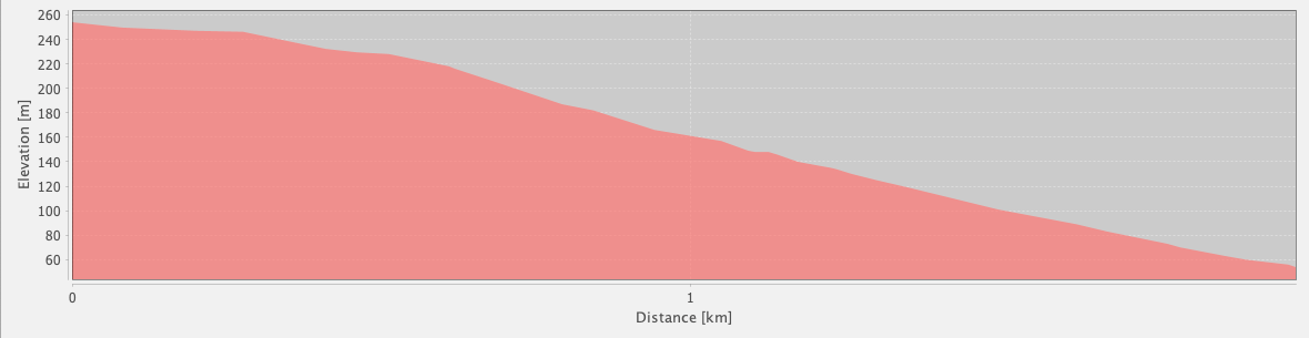
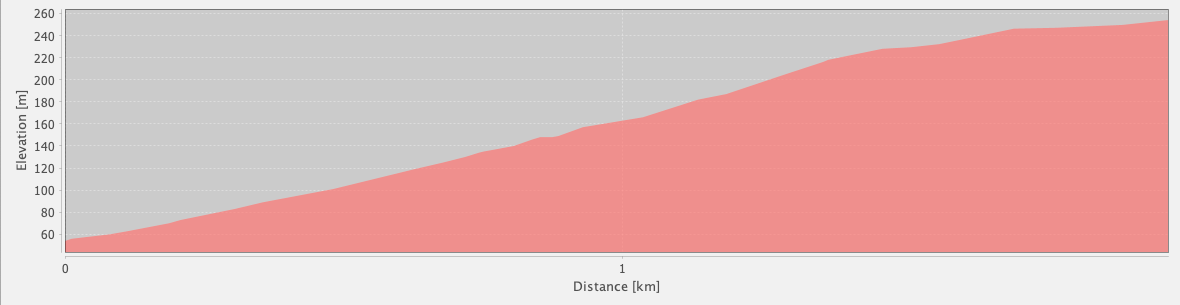
Bypass Path
Akbel – Kalkan
(by road)
ID: 
28

Off-route (unofficial) shortcut along paved roads connecting Akbel to Kalkan. Useful if you are tight on time or simply want to cut the entire Gelemiş / Patara loop from your hike.

View of Kalkan
Image credit:  
T Roszkowski
, All rights reserved

Essentials

Akbel (village)
Kalkan (town)
N–S section with Kalkan to the S.
Steady, smooth descent towards the S, with an average slope of about 10%.
Follows paved roads the entire way.
Not way-marked. This is entirely off-route. It’s easy to find your way, though.

Metrics

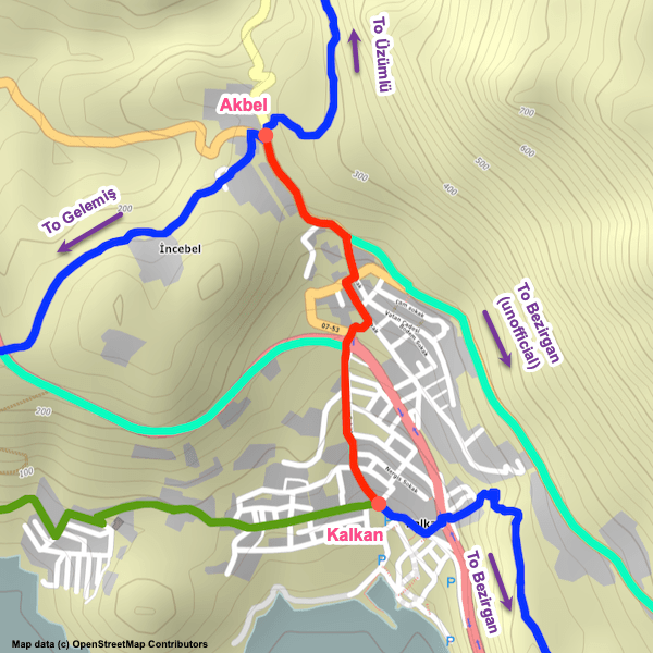
Select the tab below corresponding to the direction you plan to walk.
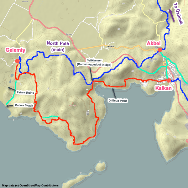
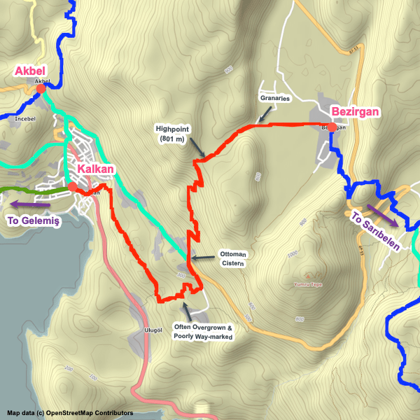
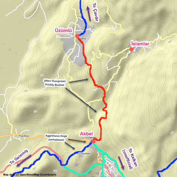
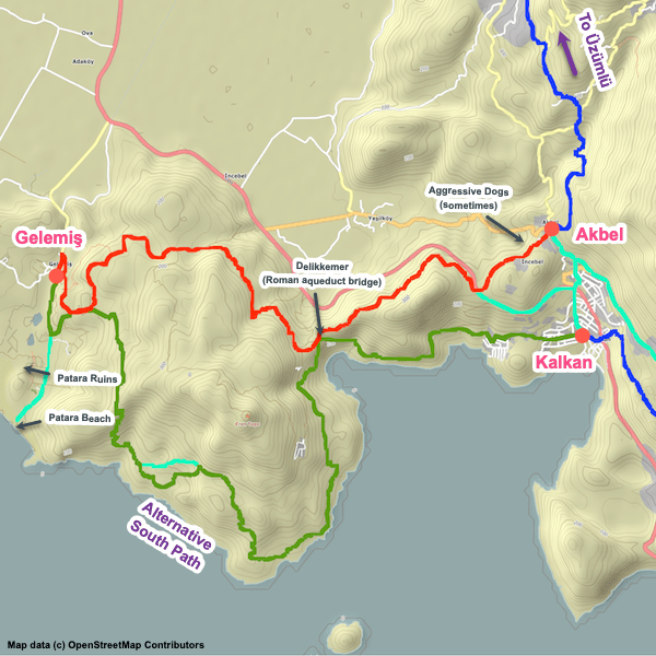
Towards Kalkan:
Towards Akbel:
2.0 km / 1.2 mi
Distance
0 m / 0 ft
Ascent
200 m / 656 ft
Descent
~0.75 hrs
Duration
Elevation chart.
2.0 km / 1.2 mi
Distance
200 m / 656 ft
Ascent
0 m / 0 ft
Descent
~0.75 hrs
Duration
Elevation chart.

Handy Things to Know

The following notes are gathered from our own experiences and from feedback sent to us by other hikers. Let us know how we can improve these notes – and thanks!

Transport

  • You can take a dolmus between Akbel and Kalkan’s bus station if you want to avoid the walk. There’s frequent service.

Attractions & Highlights

Notable highlights along the trail and at either endpoint include:

Accommodations

Here’s what we’re currently tracking for this trail section:
  • Annotated map of Gül Pansiyon in Kalkan
    Guesthouse
    Gül Pansiyon
    In Kalkan
  • Annotated map of Kleo Pension in Kalkan
    Guesthouse
    Kleo Pension
    In Kalkan
  • Annotated map of Neruda Pansiyon in Kalkan
    Guesthouse
    Neruda Pansiyon
    In Kalkan
  • Annotated map of Old Town Hotel Kalkan in Kalkan
    Hotel
    Old Town Hotel Kalkan
    In Kalkan
  • Annotated map of Rhapsody Hotel in Kalkan
    Hotel
    Rhapsody Hotel
    In Kalkan
  • Annotated map of Türk Evi (Hotel) in Kalkan
    Hotel
    Türk Evi (Hotel)
    In Kalkan
  • Annotated map of White House Pension in Kalkan
    Guesthouse
    White House Pension
    In Kalkan
  • Annotated map for Courtyard Hotel Kalkan in Kalkan
    Hotel
    Courtyard Hotel Kalkan
    In Kalkan

Wild Camping Locations

Here are the wild camping locations that we’re currently tracking along this trail section:
  • Campsite behind mosque in Akbel
    Wild Campsite
    Campsite Behind Mosque
    In Akbel

Water Sources

Here are the water sources that we’re currently tracking along this trail section or at either endpoint:
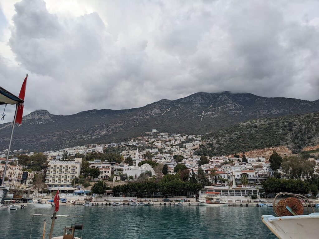
Where to Next?

From Kalkan:

  • Map showing the Lycian Way between Gelemiş and Kalkan via the southern path.
    Alternate Path
    Gelemiş – Kalkan
    Distance
    20.3 km / 12.6 mi
    Ascent
    860 m / 2822 ft
    Descent
    820 m / 2690 ft
    Est. Duration
    8.0
    This is the southern half of the loop between Gelemiş and Delikkemer, staying close to the coastline for much of its length, as well as the difficult but very attractive stretch between Delikkemer and Kalkan.
  • Map of the Lycian Way between Kalkan and Bezirgan.
    Main Path
    Kalkan – Bezirgan
    Distance
    10.3 km / 6.4 mi
    Ascent
    845 m / 2,772 ft
    Descent
    160 m / 525 ft
    Est. Duration
    4.3
    Steep, sometimes rugged, sometimes confusing section linking the town of Kalkan with the mountain village of Bezirgan.

From Akbel:

  • Map showing the Lycian Way between Üzümlü and Akbel.
    Main Path
    Üzümlü – Akbel
    Distance
    5.9 km / 3.7 mi
    Ascent
    305 m / 1,001 ft
    Descent
    360 m / 1,181 ft
    Est. Duration
    2.6
    Section linking Üzümlü and Akbel and passing through the outskirts of İslamlar.
  • Map showing the Lycian Way between Akbel and Gelemiş via the northern path.
    Main Path
    Akbel – Gelemiş (Patara Village)
    Distance
    14.5 km / 9.0 mi
    Ascent
    355 m / 1,165 ft
    Descent
    595 m / 1,952 ft
    Est. Duration
    5.2
    Attractive section linking the villages of Akbel and Gelemiş (aka Patara Village), passing by the extremely impressive Delikkemer Roman aqueduct and finishing close to the excellent Patara ruins and its nearby beach.

Pretty Pictures

Sometimes nothing beats a good photo. Or even a bad photo! If you’d like to share some or all of your photo collection with the Trekopedia community, contact us at photos@trekopedia.com and we can arrange a transfer of them. And thanks!
All photos are copyright by their respective owners and are used with permission.

How You Can Help

Trail research is never actually done. Here’s some of what we’re looking for:
✅   More photos! Ideally with geo-location information in the metadata. In addition to using some photos on Trekopedia, we add them to our internal reference database which significantly helps us with trail research. The more photos, the better! If you are willing to share your collection with us, we’d be incredibly grateful. Let us know and we’ll arrange a transfer.

✅   Points of interest. Help us identify (and geo-locate) accommodations, attractions, restaurants, markets, trail waypoints, confusing or problematic junctions, difficult or hazardous places, water sources, and so on. 

✅   Tips & recommendations. Share your thoughts with other hikers.
In addition to the above, please see this article for information on more general ways you can help. Thanks!
0 0 votes
Article Rating
Subscribe
Notify of
guest
0 Comments
Inline Feedbacks
View all comments
0
Would love your thoughts, please comment.x
()
x