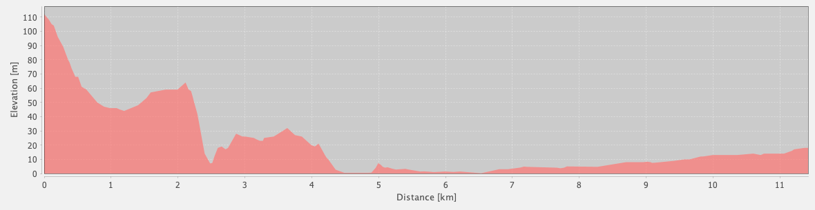
Alternate Path
Kapaklı – Demre (via Çayağzı)
ID: 
42

Popular alternative to the main path between Kapaklı and Demre / Myra, going via the hamlet of Çayağzı instead.

Coastline view from east of Cakil Beach between between Kapaklı and the junction near Çayağzı
Image credit:  
Stu Hackett
, All rights reserved

Essentials

Kapaklı (village)
Demre (town)
Winding SW–NE section with Demre / Myra ruins to the NE.
Has some small hills on the W end, with a modest slope descending overall towards Çayağzı. Between Çayağzı and the Myra ruins at the N edge of Demre, it is essentially flat.
The W end near Kapaklı is mostly rocky, uneven terrain. Near Çayağzı is some beach walking. The rest of the section is along paved roads into and through Demre.
Waymarkings are generally good.

Metrics

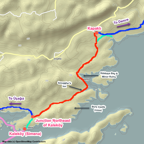
Select the tab below corresponding to the direction you plan to walk.
Towards Demre:
Towards Kapaklı:
11.4 km / 7.1 mi
Distance
84 m / 276 ft
Ascent
180 m / 591 ft
Descent
~3.0 hrs
Duration
Elevation chart.
11.4 km / 7.1 mi
Distance
180 m / 591 ft
Ascent
84 m / 276 ft
Descent
~3.0 hrs
Duration
Elevation chart.

Handy Things to Know

The following notes are gathered from our own experiences and from feedback sent to us by other hikers. Let us know how we can improve these notes – and thanks!

Highlights

  • The museum / ruins of Andriake are interesting. Has an admission fee.
  • Myra’s ruins (also has an admission fee) are extensive and superb. Definitely worth some time.

Route Planning

  • Most of this section is along paved roads and most hikers don’t find it particularly appealing, other than the ruins of Andriake and the Church of St. Nicholas. A popular option is to take a taxi or dolmuş between the Andriake ruins (which are adjacent to the hamlet of Çayağzı) and the Myra ruins (or your accommodation in Demre) rather than walking it.
  • Based on the feedback we’ve received, most hikers opt to follow the alternate path via Çayağzı. That’s our preference as well – the main path is more scenic, but nothing special enough to be worth the much longer, harder hike. We’d rather have more time available for the Myra ruins.

Alerts / Hazards

  • The W end of this section, between Kapaklı and the beach N of Çayağzı, has a rugged, uneven, rocky path – watch your footing.

Camping

  • Commercial camping spots are available at Çayağzı.

Amenities

  • A full range of amenities are available in Demre with a more limited selection available in Kapaklı and the hamlet of Çayağzı.

Transport

  • Taxi service can be arranged between Çayağzı and Demre.

Attractions & Highlights

Notable highlights along the trail and at either endpoint include:
  • Andriake Ruins by Çayağzı
    Historical Site
    Andriake Museum / Ruins
  • Church of St. Nicholas in Demre
    Historical Site
    Church of St Nicholas
    In Demre
  • Myra Ruins in Demre
    Historical Site
    Myra Ruins
    In Demre

Accommodations

Here’s what we’re currently tracking for this trail section:
  • Annotated map of Senay Ablanın Yeri in Kapaklı
    Guesthouse
    Senay Ablanın Yeri
    In Kapaklı
  • Annotated map of Andriake Camping in Çayağzı
    Commercial Campground
    Andriake Camping
    At Çayağzı
  • Annotated map of Mina Suit Apart in Demre
    Hotel
    Mina Suit Apart
    In Demre
  • Dufa Bungalow in Demre
    Hotel
    Dufa Bungalow
    In Demre
  • Şahin Paradise Hotel in Demre
    Hotel
    Şahin Paradise Hotel
    In Demre

Wild Camping Locations

Here are the wild camping locations that we’re currently tracking along this trail section:
  • Campsite Slightly Southeast of Kapaklı
    Wild Campsite
    Campsite
    Slightly Southeast of Kapaklı
  • Campsite slightly southeast of Kapaklı
    Wild Campsite
    Campsite
    Slightly Southeast of Kapaklı
  • Cistern in Kayaköy
    Wild Campsite
    Campsite
    Slightly Southeast of Kapaklı
  • Campsite at Çayağzı
    Wild Campsite
    Campsite
    At Çayağzı

Water Sources

Here are the water sources that we’re currently tracking along this trail section or at either endpoint:
  • Water Source West of Cakil Beach Between Kapaklı & Çayağzı
    Water Source
    Water Source West of Cakil Beach
    Between Kapaklı & Çayağzı

Where to Next?

From Demre:

  • Map of the Lycian Way between Demre and the Alakilise ruins.
    Main Path
    Demre – Alakilise Ruins
    Distance
    12.5 km / 7.8 mi
    Ascent
    1,138 m / 3,733 ft
    Descent
    332 m / 1,088 ft
    Est. Duration
    5.75
    Westernmost portion of the remote, beautiful 39 km / 24 mi mountain route between Demre / Myra and Finike, usually done over three stages and typically requiring camping.

From Kapaklı:

  • Map of the Lycian Way between Kaleköy and Kapaklı.
    Main Path
    Kaleköy (Simena) – Kapaklı
    Distance
    6.5 km / 4.0 mi
    Ascent
    195 m / 640 ft
    Descent
    87 m / 285 ft
    Est. Duration
    2.0
    Attractive, remote section linking Kaleköy with Kapaklı. This section consists of rolling hills, passing Smuggler’s Inn (a remote restaurant), and two different ruins of castles.

Pretty Pictures

Sometimes nothing beats a good photo. Or even a bad photo! If you’d like to share some or all of your photo collection with the Trekopedia community, contact us at photos@trekopedia.com and we can arrange a transfer of them. And thanks!
All photos are copyright by their respective owners and are used with permission.
  • Lots of goats on road just E of Kapaklı
    Lots of goats on road just E of Kapaklı
    Photo by 
    Anna Flack
     – 
    Fall 2022
  • Looking towards Cakil Beach
    Looking towards Cakil Beach
    Photo by 
    Anna Flack
     – 
    Fall 2022
  • Coastline view from east of Cakil Beach between between Kapaklı and the junction near Çayağzı
    Coastline view from east of Cakil Beach between Kapaklı and the junction near Çayağzı
    Photo by 
    Stu Hackett
     – 
    Spring 2016

How You Can Help

Trail research is never actually done. Here’s some of what we’re looking for:
✅   More photos! Ideally with geo-location information in the metadata. In addition to using some photos on Trekopedia, we add them to our internal reference database which significantly helps us with trail research. The more photos, the better! If you are willing to share your collection with us, we’d be incredibly grateful. Let us know and we’ll arrange a transfer.

✅   Points of interest. Help us identify (and geo-locate) accommodations, attractions, restaurants, markets, trail waypoints, confusing or problematic junctions, difficult or hazardous places, water sources, and so on. 

✅   Tips & recommendations. Share your thoughts with other hikers.
In addition to the above, please see this article for information on more general ways you can help. Thanks!
0 0 votes
Article Rating
Subscribe
Notify of
guest
0 Comments
Inline Feedbacks
View all comments
0
Would love your thoughts, please comment.x
()
x