Main Path
Kaş – Limanağzı
ID: 
35

Very scenic coastal path over small, rolling hills with a moderately challenging portion (steep, rugged, with ropes for balance) at the S end.

Cliff Tombs Near Limanağzı.
Image credit:  
Anna Flack
, All rights reserved

Essentials

Kaş (town)
Limanağzı (hamlet)
Generally NNW–SSE section, with Limanağzı to the SSE, that mostly hugs the coastline. Passes through the beach resort of Büyük Çakıl, a little to the SE of Kaş.
Traverses rolling small hills along the coastline, most of which are gentle or only moderately steep, but a couple of which are very steep (25%+), including one scenic cliffside stretch requiring usage of ropes attached to the hillside.
The trail mostly follows rural roads, though the Limanağzı portion is off-road on rugged trails and the portion between Kaş and Büyük Çakıl is entirely on or alongside paved / cobblestone roads.
Way-finding is generally pretty good, though some recent construction has made a few junctions mildly confusing.

Metrics

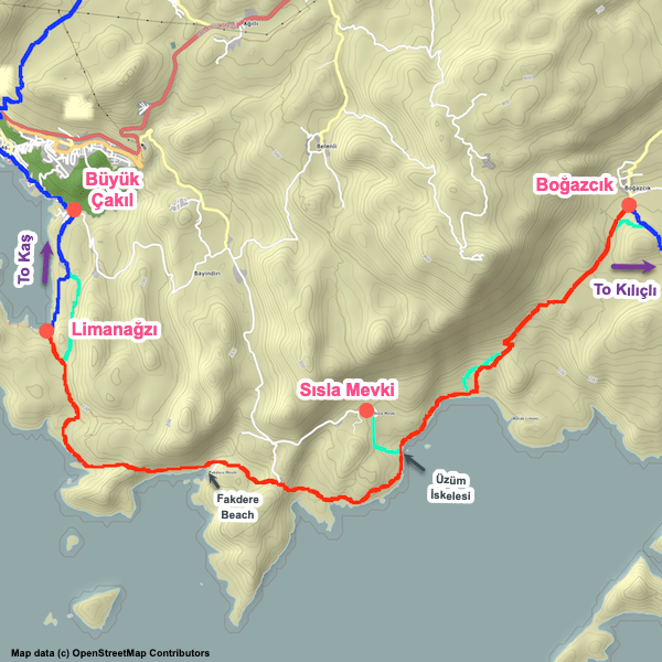
Select the tab below corresponding to the direction you plan to walk.
Towards Limanağzı:
Towards Kaş:
4.1 km / 2.5 mi
Distance
130 m / 427 ft
Ascent
125 m / 410 ft
Descent
~1.4 hrs
Duration
Elevation chart.
4.1 km / 2.5 mi
Distance
125 m / 410 ft
Ascent
130 m / 427 ft
Descent
~1.4 hrs
Duration
Elevation chart.

Handy Things to Know

The following notes are gathered from our own experiences and from feedback sent to us by other hikers. Let us know how we can improve these notes – and thanks!

Water

  • Water is available in several locations.

Highlights

  • There are great views of the bay throughout the entire section.
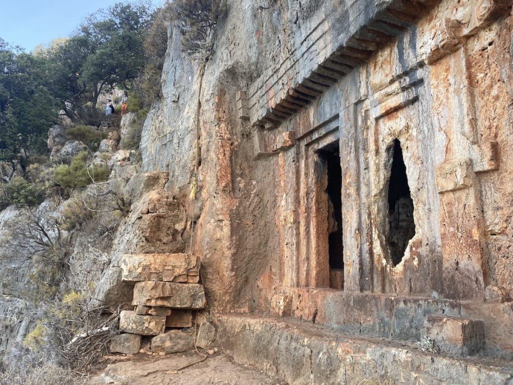
  • Near Limanağzı is an exhilarating portion that uses rope handholds to pass some Lycian tombs cut into the cliff face.

Route Planning

  • The challenging portion near Limanağzı can optionally be bypassed if desired using a path that cuts inland, away from Limanağzı.

Alerts / Hazards

  • In bad weather (in particular, high winds), the ‘inland’ variant near Limanağzı is recommended. Likewise, if you are carrying a bulky, heavy pack the inland variant might be better.

Amenities

  • In addition to the endpoints, food and beverage can usually be obtained at Büyük Çakıl, which has a nice pebble beach that makes for a good lunch break location.

Attractions & Highlights

Notable highlights along the trail and at either endpoint include:
  • Ruins of Hellenistic Temple in Kaş
    Historical Site
    Ruins of Hellenistic Temple
    In Kaş
  • Amphitheatre in Kaş
    Historical Site
    Kaş Amphitheatre
    In Kaş
  • King's Tomb in Kaş
    Historical Site
    King’s Tomb
    In Kaş
  • Lycian Tombs Near Amphitheatre in Kaş
    Historical Site
    Lycian Tombs Near Amphitheatre
    In Kaş
  • Rock Tombs Along Cliff Face in Kaş
    Historical Site
    Rock Tombs Along Cliff Face
    In Kaş
  • Cliff Face Tombs near Limanağzı
    Historical Site
    Cliff Tombs
    Near Limanağzı

Accommodations

Here’s what we’re currently tracking for this trail section:
  • Meltem Pension & Guest House in Kaş
    Guesthouse
    Meltem Pension & Guest House
    In Kaş
  • Rhapsody Hotel in Kaş
    Hotel
    Rhapsody Hotel
    In Kaş
  • Annotated map of 8 Pansiyon (aka Sekiz Pansiyon) in Kaş
    Guesthouse
    8 Pansiyon (aka Sekiz Pansiyon)
    In Kaş
  • Annotated map of Kaş Camping in Kaş
    Commercial Campground
    Kaş Camping
    In Kaş
  • Annotated map of La Kumasal Hotel in Kaş
    Hotel
    La Kumasal Hotel
    In Kaş
  • Annotated map of Mina Apart Hotel in Kaş
    Hotel
    Mina Apart Hotel
    In Kaş
  • Annotated map of Hotel Puya in Kaş
    Hotel
    Hotel Puya
    In Kaş
  • Annotated map of Kayahan Hotel in Kaş
    Hotel
    Kayahan Hotel
    In Kaş
  • Annotated map of Gizli Vadi Kamp & Pansiyon in Büyük Çakıl
    Guesthouse / Camping
    Gizli Vadi Kamp & Pansiyon
    In Büyük Çakıl
  • Harnup Camping in Büyük Çakıl
    Commercial Campground
    Harnup Camping
    In Büyük Çakıl
  • Annotated map of Nuri's Beach Bungalow in Limanağzı
    Guesthouse
    Nuri’s Beach Bungalow
    In Limanağzı

Wild Camping Locations

Here are the wild camping locations that we’re currently tracking along this trail section:

Water Sources

Here are the water sources that we’re currently tracking along this trail section or at either endpoint:
  • Fountain at Mosque in Büyük Çakıl
    Water Source
    Fountain at Mosque
    In Büyük Çakıl

Where to Next?

From Limanağzı:

  • Map of the Lycian Way between Limanağzı and Boğazcık.
    Main Path
    Limanağzı – Boğazcık
    Distance
    15.0 km / 9.3 mi
    Ascent
    750 m / 2,461 ft
    Descent
    470 m / 1,542 ft
    Est. Duration
    5.75
    Long, rugged, mostly very remote section connecting Limanağzı with Boğazcık. Has many great coastline views.

From Kaş:

  • Map of the Lycian Way between Çukurbağ and Kaş.
    Main Path
    Çukurbağ – Kaş
    Distance
    7.0 km / 4.3 mi
    Ascent
    68 m / 223 ft
    Descent
    555 m / 1,821 ft
    Est. Duration
    2.75
    Rugged, steep section with beautiful views linking the village of Çukurbağ with the coastal town of Kaş.

Pretty Pictures

Sometimes nothing beats a good photo. Or even a bad photo! If you’d like to share some or all of your photo collection with the Trekopedia community, contact us at photos@trekopedia.com and we can arrange a transfer of them. And thanks!
All photos are copyright by their respective owners and are used with permission.
  • View of Büyük Çakıl beach
    View of Büyük Çakıl beach
    Photo by 
    Ann Halloran
     – 
    Sept 2022
  • View from Limanağzı looking towards Kaş.
    View from Limanağzı looking towards Kaş
    Photo by 
    Anna Flack
     – 
    Fall 2022
  • Using rope to descend near Limanağzı
    Using rope to descend near Limanağzı
    Photo by 
    Irene Dijkmans
     – 
    Fall 2022
  • Cliff Tombs Near Limanağzı.
    Tombs near Limanağzı with rope handholds
    Photo by 
    Anna Flack
     – 
    Fall 2022

How You Can Help

Trail research is never actually done. Here’s some of what we’re looking for:
✅   More photos! Ideally with geo-location information in the metadata. In addition to using some photos on Trekopedia, we add them to our internal reference database which significantly helps us with trail research. The more photos, the better! If you are willing to share your collection with us, we’d be incredibly grateful. Let us know and we’ll arrange a transfer.

✅   Points of interest. Help us identify (and geo-locate) accommodations, attractions, restaurants, markets, trail waypoints, confusing or problematic junctions, difficult or hazardous places, water sources, and so on. 

✅   Tips & recommendations. Share your thoughts with other hikers.
In addition to the above, please see this article for information on more general ways you can help. Thanks!
0 0 votes
Article Rating
Subscribe
Notify of
guest
0 Comments
Inline Feedbacks
View all comments
0
Would love your thoughts, please comment.x
()
x