Main Path
Gökceören – Çukurbağ
ID: 
33

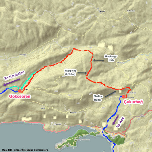
Long attractive section through rugged surroundings between the villages of Gökceören and Çukurbağ that is constantly either ascending or descending (though not overly steeply for the most part). Passes through the notable Phellos ruins.

Tomb at Phellos.

Essentials

Gökceören (village)
Çukurbağ (village)
The endpoints are W–E with the northeastern edge of Çukurbağ to the E. Most of the section arcs well to the N.
The western third of this section is a relatively gentle slope (1.2% to about 7.5%) descending towards the NE (away from Gökceören). The remainder is a climb / descent of a ridge with some steep portions on both sides – 17%+ for much of the W side and 14% on the smaller E side.
The W half is mainly along tracks and unpaved forest roads through attractive terrain. The rest is a mix of nice woodland trails (albeit rocky in some places), tracks through fields (some with shepherd’s huts), and hillside footpaths.
Way-finding is typical; mostly clear but there are a number of potentially confusing junctions (check your position again our GPS tracks periodically).

Metrics

Select the tab below corresponding to the direction you plan to walk.
Towards Çukurbağ:
Towards Gökceören:
21.6 km / 13.4 mi
Distance
795 m / 2,608 ft
Ascent
1,145 m / 3,757 ft
Descent
~8.75 hrs
Duration
Elevation chart.
21.6 km / 13.4 mi
Distance
1,145 m / 3,757 ft
Ascent
795 m / 2,608 ft
Descent
~8.75 hrs
Duration
Elevation chart.

Handy Things to Know

The following notes are gathered from our own experiences and from feedback sent to us by other hikers. Let us know how we can improve these notes – and thanks!

Water

  • Several water sources available though the water status will depend heavily on the time of year. For safety, bring plenty of water with you.

Highlights

  • Passes through the notable Phellos ruins, which are worth spending some time exploring.

Tips

  • The hillside footpaths on the eastern end are narrow in some places and can sometimes gets overgrown.

Alerts / Hazards

  • We’ve had multiple reports of wild boars in the area

Camping

  • Lots of decent camping spots available.

Attractions & Highlights

Notable highlights along the trail and at either endpoint include:
  • Phellos Ruins Between Gökceören & Çukurbağ
    Historical Site
    Phellos Ruins
    Between Gökceören & Çukurbağ

Accommodations

Here’s what we’re currently tracking for this trail section:
  • Annotated map of Yesil Apartment (Hüseyin Yılmaz's Pansiyon) in Gökceören
    Guesthouse
    Yesil Apartment (Hüseyin Yılmaz’s Pansiyon)
    In Gökceören
  • Annotated map of Villa Kurt in Çukurbağ.
    Guesthouse
    Villa Kurt
    In Çukurbağ
  • Annotated map of 3 Oda Kaş between Çukurbağ & Kaş
    Guesthouse
    3 Oda Kaş
    Between Çukurbağ & Kaş

Where to Next?

From Çukurbağ:

  • Map of the Lycian Way between Çukurbağ and Kaş.
    Main Path
    Çukurbağ – Kaş
    Distance
    7.0 km / 4.3 mi
    Ascent
    68 m / 223 ft
    Descent
    555 m / 1,821 ft
    Est. Duration
    2.75
    Rugged, steep section with beautiful views linking the village of Çukurbağ with the coastal town of Kaş.

From Gökceören:

  • Map of the Lycian Way between Sarıbelen and Gökceören.
    Main Path
    Sarıbelen – Gökceören
    Distance
    12.0 km / 7.5 mi
    Ascent
    480 m / 1,575 ft
    Descent
    415 m / 1,362 ft
    Est. Duration
    4.5
    Winding, hilly, and mostly remote mountain section between Sarıbelen and Gökceören with some steep and rugged parts.

Pretty Pictures

Sometimes nothing beats a good photo. Or even a bad photo! If you’d like to share some or all of your photo collection with the Trekopedia community, contact us at photos@trekopedia.com and we can arrange a transfer of them. And thanks!
All photos are copyright by their respective owners and are used with permission.
  • Shepherd's hut between Gökceören and Pınarbaşı.
    Shepherds’ hut between Gökceören and Pınarbaşı
    Photo by 
    Anna Flack
     – 
    Fall 2022
  • Hikers on a rest break at the shepherd's hut.
    Hikers on a rest break at the shepherds’ hut
    Photo by 
    Anna Flack
     – 
    Fall 2022
  • Hiker enjoying the view between Gökceören and Çukurbağ
    Hiker enjoying the view
    Photo by 
    T Roszkowski
     – 
    Spring 2022
  • Road departing Gökceören for Phellos
    Road departing Gökceören for Phellos
    Photo by 
    Susanne Rieder
     – 
    Nov 2022
  • Peaceful forest trail between Gökceören & Çukurbağ
    Peaceful forest trail between Gökceören & Çukurbağ
    Photo by 
    Stu Hackett
     – 
    Spring 2016
  • Forest track between Gökceören and Phellos
    Forest track between Gökceören and Phellos
    Photo by 
    Susanne Rieder
     – 
    Nov 2022

How You Can Help

Trail research is never actually done. Here’s some of what we’re looking for:
✅   More photos! Ideally with geo-location information in the metadata. In addition to using some photos on Trekopedia, we add them to our internal reference database which significantly helps us with trail research. The more photos, the better! If you are willing to share your collection with us, we’d be incredibly grateful. Let us know and we’ll arrange a transfer.

✅   Points of interest. Help us identify (and geo-locate) accommodations, attractions, restaurants, markets, trail waypoints, confusing or problematic junctions, difficult or hazardous places, water sources, and so on. 

✅   Tips & recommendations. Share your thoughts with other hikers.
In addition to the above, please see this article for information on more general ways you can help. Thanks!
0 0 votes
Article Rating
Subscribe
Notify of
guest
0 Comments
Inline Feedbacks
View all comments
0
Would love your thoughts, please comment.x
()
x