Alternate Path
Kabak – Alınca
(via ridge)
ID: 
15

Alternative approach linking the ‘upper’ village of Kabak with the village of Alınca following a ridge (sometimes by steep edges).


Beautiful but challenging path with a lot of ascending and descending over rugged terrain. It is shorter and a bit easier than the main variant (which goes via Kabak Beach).

Painted directions on boulder at 3-way merge point above Kabak Beach.
Image credit:  
Stu Hackett
, All rights reserved

Essentials

Kabak (village)
Alınca (village)
The endpoints are NW–SE of each other but most of the path is a huge bulge towards the NE.
The Kabak-side 60% of this section is mostly rolling small-but-steep hills generally following a ridge overlooking the coast. Multiple small stretches of this portion have slopes in excess of 30% even though the net elevation change is relatively small (about 150 m over 4 km). The Alınca-side 40% of this section is one long slope, rising towards Alınca, at about 20% average grade over its roughly 2.6 km.
Much of this section is over rugged, rocky terrain. The footpaths are generally good but care still needs to be taken to avoid stumbles.
Way-finding is generally good, with blazes and signposts at key junctions.

Metrics

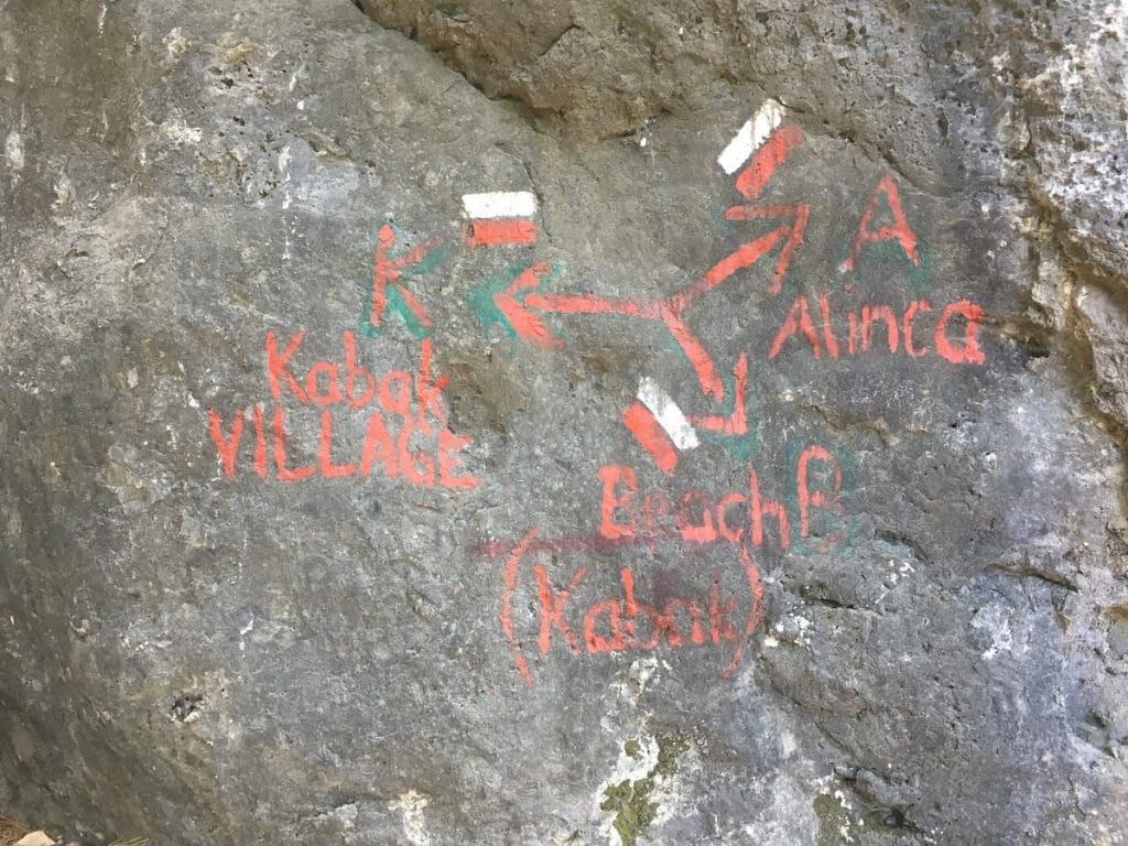
Select the tab below corresponding to the direction you plan to walk.
Towards Alınca:
Towards Kabak:
6.4 km / 4.0 mi
Distance
875 m / 2,871 ft
Ascent
380 m / 1,247 ft
Descent
~4.0 hrs
Duration
Elevation chart.
6.4 km / 4.0 mi
Distance
380 m / 1,247 ft
Ascent
875 m / 2,871 ft
Descent
~4.0 hrs
Duration
Elevation chart.

Handy Things to Know

The following notes are gathered from our own experiences and from feedback sent to us by other hikers. Let us know how we can improve these notes – and thanks!

Water

  • Water is available at or near both endpoints. There are a couple of fountains along the trail though they are unreliable.

Highlights

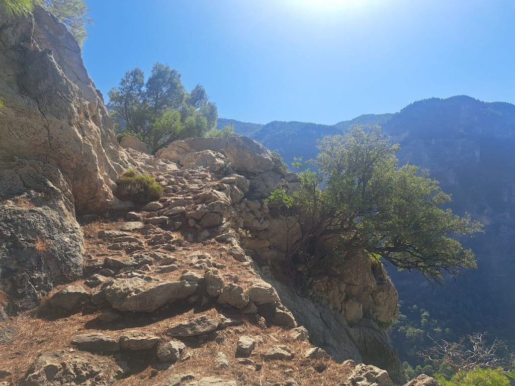
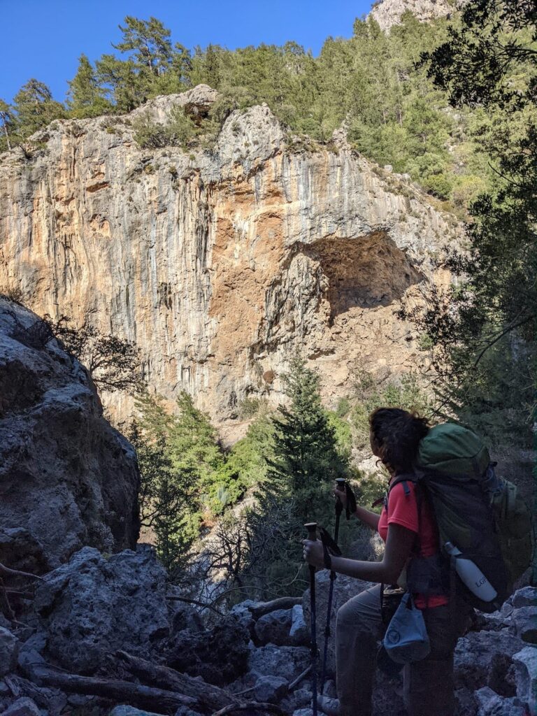
  • There are many spectacular views from along this section overlooking the coastline.

Route Planning

  • This is an alternate path. It is shorter and a bit easier than the main variant (which goes via Kabak Beach) but this variant is almost as difficult due to the many short but very steep hills.
  • This section merges with / branches from the main Kabak Beach path roughly at the mid-point (right where this section, heading eastward, begins its main ascent).
  • We prefer the Kabak Beach variant but both are good.

Accommodations

  • Accommodations are available at both endpoints but there’s nothing available along the trail itself.

Camping

  • Some very nice wild camping locations offering outstanding views over the coastline.

Amenities

  • There’s sometimes a beverage stand available a bit N of Alınca which has an honour-system payment box for whenever it is untended.

Transport

  • Dolmuş service is reliably available from the Kabak end.
  • Service to / from Alınca can be unreliable. If you expect to need service from there, check in advance on current service standards (it changes frequently).

Accommodations

Here’s what we’re currently tracking for this trail section:
  • Annotated map of Sea Valley Bungalows in Kabak
    Bungalows
    Sea Valley Camping
    At Kabak Beach
  • Annotated map of Olive Garden Kabak in Kabak
    Hotel & Restaurant
    Olive Garden Kabak
    In Kabak
  • Annotated map of Pedro Mama's in Kabak
    Guesthouse
    Pedro Mama’s
    In Kabak
  • Annotated map of Bağ Camp West of Kabak Beach
    Commercial Campground
    Bağ Camp
    West of Kabak Beach
  • Annotated map of Sultan Camping in Kabak
    Bungalows
    Sultan Camping
    In Kabak
  • Annotated map of Kabak Valley Kamp in Kabak
    Commercial Campground
    Kabak Valley Kamp
    In Kabak
  • Annotated map of Turan Hill Lounge in Kabak
    Bungalows
    Turan Hill Lounge
    In Kabak
  • Annotated map of Secret Garden Kabak in Kabak
    Commercial Campground
    Secret Garden Kabak
    In Kabak
  • Annotated map of Shiva Camp in Kabak
    Commercial Campground
    Shiva Camp
    In Kabak
  • Annotated map of Bayram’s Place in Alınca
    Bungalows / Commercial Campground
    Bayram’s Place
    In Alınca
  • Annotated map of LeChic Glamping Hotel in Alınca
    Bungalows
    LeChic Glamping Hotel
    In Alınca
  • Annotated map of Likya Guesthouse / Camping in Alınca
    Guesthouse
    Likya Guesthouse / Camping
    In Alınca

Wild Camping Locations

Here are the wild camping locations that we’re currently tracking along this trail section:
  • Campsite between Kabak & Alınca
    Wild Campsite
    Campsite
    Between Kabak & Alınca
  • Campsite between Kabak & Alınca
    Wild Campsite
    Campsite
    Between Kabak & Alınca
  • Campsite between Kabak & Alınca
    Wild Campsite
    Campsite
    Between Kabak & Alınca
  • Campsite between Kabak & Alınca
    Wild Campsite
    Campsite
    Between Kabak & Alınca

Water Sources

Here are the water sources that we’re currently tracking along this trail section or at either endpoint:
  • Fountain in Kabak
    Water Source
    Fountain
    In Kabak
  • Fountain and toilets at mosque in Kabak
    Water Source
    Fountain and Toilets at Mosque
    In Kabak
  • Fountain by Lissiya Hotel in Kabak
    Water Source
    Fountain by Lissiya Hotel
    In Kabak
  • Fountain in Kabak
    Water Source
    Fountain
    In Kabak
  • Water fountain between Kabak & Alınca
    Water Source
    Fountain
    Between Kabak & Alınca
  • Water fountain between Kabak & Alınca
    Water Source
    Fountain
    Between Kabak & Alınca
  • Map of Water fountain between Kabak & Alınca [216] [CE2715]
    Water Source
    Water Fountain
    Between Kabak & Alınca
  • Water source between Kabak & Alınca
    Water Source
    Water Source
    Between Kabak & Alınca

Where to Next?

From Alınca:

  • Map showing the Lycian Way between Kabak Beach and Alınca.
    Main Path
    Kabak Beach – Alınca
    Distance
    6.0 km / 3.7 mi
    Ascent
    925 m / 3,035 ft
    Descent
    200 m / 656 ft
    Est. Duration
    3.6
    Challenging, beautiful section between Kabak Beach and the village of Alınca that will give your legs and lungs a good workout. There is nothing technically difficult about this section – it is just non-stop climbing or descending.
  • Map showing the Lycian Way between Alınca and Gey.
    Main Path
    Alınca – Yediburunlar (Gey)
    Distance
    7.7 km / 4.8 mi
    Ascent
    460 m / 1,509 ft
    Descent
    560 m / 1,837 ft
    Est. Duration
    3.75
    Challenging but spectacular section between the villages of Alınca and Yediburunlar (Gey).
  • Map showing the Lycian Way between Alınca and Dodurga.
    Alternate Path
    Alınca – Dodurga
    Distance
    10.7 km / 6.6 mi
    Ascent
    475 m / 1,558 ft
    Descent
    650 m / 2,133 ft
    Est. Duration
    4.6
    Popular variant with some challenging but spectacular portions at the NW end as well as a fair bit of rural road-walking over most of the rest. Passes the intriguing Sidyma ruins upon which Dodurga is built.

From Kabak:

  • Map showing the Lycian Way between Faralya and Kabak.
    Main Path
    Faralya – Kabak
    Distance
    4.8 km / 3.0 mi
    Ascent
    280 m / 919 ft
    Descent
    355 m / 1,165 ft
    Est. Duration
    2.3
    Enjoyable hilly, forested section with some nice views. There are lots of accommodation options at both ends of this section plus some camping spots along the way.
  • Map showing the Lycian Way between Kabak and Kabak Beach.
    Main Path
    Kabak – Kabak Beach
    Distance
    1.7 km / 1.1 mi
    Ascent
    30 m / 98 ft
    Descent
    260 m / 853 ft
    Est. Duration
    1.0
    Main path connecting the ‘upper’ village of Kabak, located partway up the hillside, with the popular beach area (which is where you’ll find most of the accommodation and F & B options, not surprisingly).

Pretty Pictures

Sometimes nothing beats a good photo. Or even a bad photo! If you’d like to share some or all of your photo collection with the Trekopedia community, contact us at photos@trekopedia.com and we can arrange a transfer of them. And thanks!
All photos are copyright by their respective owners and are used with permission.
  • On road in Alınca
    On road in Alınca
    Photo by 
    Darren Moens
     – 
    Fall 2022
  • Hiker passing sheer cliffs between Kabak and Alınca
    Hiker passing sheer cliffs between Kabak and Alınca
    Photo by 
    T Roszkowski
     – 
    Spring 2022
  • Hiker between Kabak and Alınca.
    Hiker between Kabak and Alınca
    Photo by 
    T Roszkowski
     – 
    Early Spring 2022
  • Rocky path between Kabak and Alınca
    Rocky path between Kabak and Alınca
    Photo by 
    Darren Moens
     – 
    Fall 2022
  • Painted directions on boulder at 3-way merge point above Kabak Beach.
    Painted directions on boulder at 3-way merge point above Kabak Beach
    Photo by 
    Stu Hackett
     – 
    Spring 2016
  • Hiker looking at sheer cliffs between Kabak and Alınca
    Hiker looking at sheer cliffs between Kabak and Alınca
    Photo by 
    T Roszkowski
     – 
    Spring 2022

How You Can Help

Trail research is never actually done. Here’s some of what we’re looking for:
✅   More photos! Ideally with geo-location information in the metadata. In addition to using some photos on Trekopedia, we add them to our internal reference database which significantly helps us with trail research. The more photos, the better! If you are willing to share your collection with us, we’d be incredibly grateful. Let us know and we’ll arrange a transfer.

✅   Points of interest. Help us identify (and geo-locate) accommodations, attractions, restaurants, markets, trail waypoints, confusing or problematic junctions, difficult or hazardous places, water sources, and so on. 

✅   Tips & recommendations. Share your thoughts with other hikers.
In addition to the above, please see this article for information on more general ways you can help. Thanks!
0 0 votes
Article Rating
Subscribe
Notify of
guest
0 Comments
Inline Feedbacks
View all comments
0
Would love your thoughts, please comment.x
()
x