Main Path (extended)
Fethiye – Kayaköy
ID: 
7

Optional extended section of the Lycian Way (which technically starts / ends in Ovacık), typically part of a stage connecting Fethiye with Ovacık and/or Ölüdeniz.


While there are certainly nicer, more memorable sections elsewhere along the trail, this makes for a pleasant, easy ‘warm-up’ for those just starting their hike or a gentle conclusion for those ending their adventure in Fethiye.

Trail blaze painted on rock.
Image credit:  
Rebecca Scheer
, All rights reserved

Essentials

Fethiye (city)
Kayaköy (village)
N-S section at the western end of the trail, with Fethiye to the north.
Mostly a climb and descent of one modest-sized hill with typical slope of about 14% on both sides.
Follows a mix of good-quality footpaths and paved roads. The southern portion is through the sprawling village of Kayaköy.
Way-finding is generally good with a mix of signposts and painted blazes. If you do happen to miss a turn, you’ll generally still end up where you need to be.

Metrics

Select the tab below corresponding to the direction you plan to walk.
Towards Kayaköy:
Towards Fethiye:
8.8 km / 5.5 mi
Distance
445 m / 1,460 ft
Ascent
320 m / 1,050 ft
Descent
~3.6 hrs
Duration
Elevation chart.
8.8 km / 5.5 mi
Distance
320 m / 1,050 ft
Ascent
445 m / 1,460 ft
Descent
~3.6 hrs
Duration
Elevation chart.

Pros & Cons

Here’s what jumps out to us about this section…
Positives
  • Good ‘warm-up’ / ‘cool down’ section.
  • The ‘ghost town’ in Kayaköy is quite interesting and worth a bit of time.
  • Full range of all major amenities at both endpoints.
Negatives
  • A nice enough section, but nothing notable. If you skip it, you won’t really miss anything major (especially since you can visit Kayaköy’s ‘ghost town’ via a dolmuş outing).
  • Significant portion is on paved road.
  • No amenities, other than water, available in-between the endpoints.

Handy Things to Know

The following notes are gathered from our own experiences and from feedback sent to us by other hikers. Let us know how we can improve these notes – and thanks!

Wayfinding

  • Moderate. There’s some trail signposts to help you stay oriented and blazes here and there.
  • For the most part this is an easy path to follow.

Water

  • There’s a couple of water fountains available along the way but it is best to load-up at the endpoints just in case.

Highlights

  • Passes the Fethiye Castle at the N end, which is worth a brief look. Has some great views looking out over Fethiye.
  • There’s some Lycian tombs at the N edge of Kayaköy as well as an old cemetery near the hilltop if you want to make some past-their-due-date ‘I see dead people’ jokes (yep, guilty as charged…).
  • The Kayaköy end of this section is at the fascinating ghost town (abandoned village). Well-worth some time exploring.

Tips

  • Where this section isn’t actually on roads it follows close to them the entire way. If weather conditions are poor, it’s possible to just stay on the roads.
  • There are several convenient off-route shortcuts you can take to slightly shorten this section, if you wish.
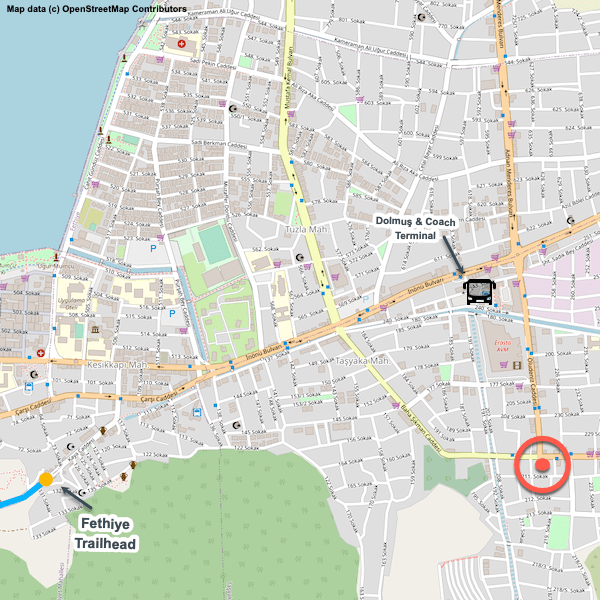
  • There’s no formal trailhead in Fethiye; we’ve simply picked a convenient location.

Route Planning

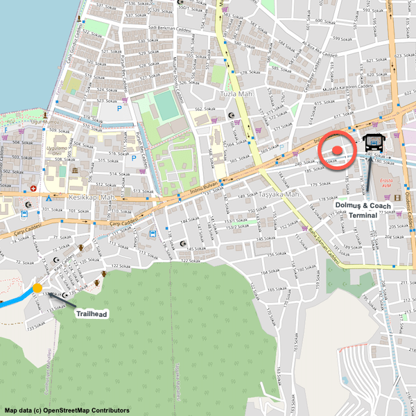
  • There’s regular / frequent dolmuş service between Fethiye and Ovacık if you want to skip this extended part of the trail.

Alerts / Hazards

  • When you are on roads, there isn’t much room on the side of them; keep an eye out for traffic, especially near curves.

Accommodations

  • There’s lots of accommodation options at both endpoints but nothing in-between.

Camping

  • We haven’t done any wild camping along this stretch, but we’ve been told by a few people that they have done so without any issues.

Amenities

  • Full range of amenities available in Fethiye.
  • Most (restaurants, market, transportation, etc.) are available in Kayaköy as well.

Transport

  • Several dolmuş stops available along the section.
  • Frequent dolmuş service is available from both endpoints to / from major locations in the region.

Attractions & Highlights

Notable highlights along the trail and at either endpoint include:
  • Annotated map of Lycian Tomb Near Cultural Centre in Fethiye
    Historical Site
    Lycian Tomb near Cultural Centre
    In Fethiye
  • Annotated map of Castle Ruins in Fethiye
    Historical Site
    Fethiye Castle Ruins
    In Fethiye
  • Annotated map of Archeological Museum in Fethiye
    Cultural
    Archeological Museum
    In Fethiye
  • Community Cultural Center in Fethiye
    Cultural
    Community Cultural Center
    In Fethiye
  • Lycian Sarcophagi Near Cliff Tombs in Fethiye
    Historical Site
    Lycian Sarcophagi Near Cliff Tombs
    In Fethiye
  • Lycian Tomb in Middle of Road in Fethiye
    Historical Site
    Lycian Tomb in Middle of Road
    In Fethiye
  • Roman Amphitheater in Fethiye
    Historical Site
    Roman Amphitheatre
    In Fethiye
  • Annotated map of Cliffside Tombs (incl Temple of Amyntas) in Fethiye
    Historical Site
    Cliffside Tombs (incl Temple of Amyntas)
    In Fethiye
  • Ghost Town Ruins in Kayaköy
    Historical Site
    Kayaköy ‘Ghost Town’
    In Kayaköy
  • Lycian Tombs at Northern Edge of Kayaköy
    Historical Site
    Hillside Tombs
    At North Edge of Kayaköy

Accommodations

Here’s what we’re currently tracking for this trail section:
  • Annotated map of Tan Pansiyon in Fethiye
    Guesthouse
    Tan Pansiyon
    In Fethiye
  • Annotated map of Fethiye Guest House in Fethiye
    Guesthouse
    Fethiye Guest House
    In Fethiye
  • Annotated map of El Camino Hostel & Pub in Fethiye
    Guesthouse
    El Camino Hostel & Pub
    In Fethiye
  • Annotated map showing Amintas Hostel
    Guesthouse
    Amintas Hostel & Motel
    In Fethiye
  • Annotated map of Blue Bells Hostel in Fethiye
    Hostel
    Blue Bells Hostel
    In Fethiye
  • Annotated map of Belci City Residence in Fethiye
    Guesthouse
    Belci City Residence
    In Fethiye
  • Annotated map of Sakura Hostel & Pub in Fethiye
    Hostel
    Sakura Hostel & Pub
    In Fethiye
  • Map - Exelans Hotel in Fethiye lvl 17
    Hotel
    Exelans Hotel
    In Fethiye
  • Annotated map of Han Camping & Pension
    Guesthouse
    Han Camping & Pension
    In Kayaköy
  • Annotated map of Misafir Evi in Kayaköy
    Guesthouse
    Misafir Evi
    In Kayaköy
  • Annotated map of Selçuk Pension in Kayaköy
    Guesthouse
    Selçuk Pension
    In Kayaköy

Wild Camping Locations

Here are the wild camping locations that we’re currently tracking along this trail section:

Water Sources

Here are the water sources that we’re currently tracking along this trail section or at either endpoint:
  • Map of Cistern in Fethiye [750] [CE600]
    Water Source
    Cistern
    In Fethiye
  • Map of Water Fountain between Fethiye & Kayaköy [266] [CE1601]
    Water Source
    Water Fountain
    Between Fethiye & Kayaköy
  • Map of Cistern in Kayaköy [752] [CE1680]
    Water Source
    Cistern
    At northern edge of Kayaköy
  • Fountain in Kayaköy
    Water Source
    Fountain in Kayaköy
    In Kayaköy
  • Map of Water Fountain in Kayaköy [753] [CE610]
    Water Source
    Water Fountain
    In Kayaköy
  • Map of Water Fountain in Kayaköy [751] [CE837]
    Water Source
    Water Fountain
    in Kayaköy
  • Map of Water Fountain by Mosque in Kayaköy [754] [CE420]
    Water Source
    Water Fountain
    In Kayaköy

Where to Next?

From Kayaköy:

The main path directly links Kayaköy with Ovacık. However, a popular alternative is to head to Ölüdeniz first. It’s a more scenic route, with nice views of Ölüdeniz’s lagoon. From there you could walk uphill to Ovacık or (recommended) just catch a dolmuş. However, keep in mind that you’ll have much better views of Ölüdeniz during the climb to Kirme from Ovacık, so you aren’t really missing anything if you head directly to Ovacık.

  • Map showing Lycian Way between Kayaköy and Ovacık.
    Main Path (Extended Trail)
    Kayaköy – Ovacık
    Distance
    5.5 km / 3.4 mi
    Ascent
    360 m / 1,181 ft
    Descent
    220 m / 722 ft
    Est. Duration
    2.5
    This is the direct option between Kayaköy and the official Lycian Way start / finish point in Ovacık, typically part of a single stage between Fethiye and Ovacık.
  • Map showing Lycian Way between Kayaköy and Ölüdeniz.
    Optional Path
    Kayaköy – Ölüdeniz
    Distance
    5.1 km / 3.2 mi
    Ascent
    210 m / 689 ft
    Descent
    365 m / 1,198 ft
    Est. Duration
    2.25
    This off-route variant ascends and descends a modest-sized hill, with very nice views down on Ölüdeniz’s famous lagoon during the descent (for eastbound walkers). Passes through Kayaköy’s intriguing ‘ghost town’ ruins.

From Fethiye:

Congratulations! You’re done. Time to go home or maybe explore some other parts of Turkey (the Carian Trail, St. Paul’s Trail, and Cappadocia are all highly recommended).


Safe travels! We hope our website has been helpful to you. If you have suggestions on how we can improve things, please let us know.


A small request: We’d love to be able to use your photo collection in our project. It helps with our trail research (sort of our own version of Google Street View) and, of course, gives us more photos to use on our website. If you want to share them with us (for the Lycian Way or any long-distance trail), let us know and we’ll arrange a transfer. And thanks!

Pretty Pictures

Sometimes nothing beats a good photo. Or even a bad photo! If you’d like to share some or all of your photo collection with the Trekopedia community, contact us at photos@trekopedia.com and we can arrange a transfer of them. And thanks!
All photos are copyright by their respective owners and are used with permission.
  • Hiking through peaceful woodlands
    Hiking through peaceful woodlands
    Photo by 
    Rebecca Scheer
     – 
    Fall 2022
  • Quiet footpath.
    Quiet footpath through woodlands between Fethiye & Kayaköy
    Photo by 
    Darren Moens
     – 
    Oct 2022
  • Lycian tombs at edge of Kayaköy.
    Tombs at edge of Kayaköy
    Photo by 
    Darren Moens
     – 
    Oct 2022
  • Looking over Kayaköy on the approach from Fethiye.
    Looking over Kayaköy on the approach from Fethiye
    Photo by 
    The Trekopedia Team
  • Rocky trail near highpoint between Fethiye and Kayaköy
    Rocky trail near highpoint between Fethiye and Kayaköy
    Photo by 
    Rebecca Scheer
     – 
    Fall 2022
  • Hiker filling a water bottle between Fethiye and Kayaköy
    Hiker filling a water bottle between Fethiye and Kayaköy
    Photo by 
    T Roszkowski
     – 
    Spring 2022
  • Kayaköy's ghost town seen from a distance on the approach from Fethiye
    Kayaköy’s ghost town seen from a distance on the approach from Fethiye
    Photo by 
    The Trekopedia Team

How You Can Help

Trail research is never actually done. Here’s some of what we’re looking for:
✅   More photos! Ideally with geo-location information in the metadata. In addition to using some photos on Trekopedia, we add them to our internal reference database which significantly helps us with trail research. The more photos, the better! If you are willing to share your collection with us, we’d be incredibly grateful. Let us know and we’ll arrange a transfer.

✅   Points of interest. Help us identify (and geo-locate) accommodations, attractions, restaurants, markets, trail waypoints, confusing or problematic junctions, difficult or hazardous places, water sources, and so on. 

✅   Tips & recommendations. Share your thoughts with other hikers.
In addition to the above, please see this article for information on more general ways you can help. Thanks!
5 1 vote
Article Rating
Subscribe
Notify of
guest
0 Comments
Inline Feedbacks
View all comments
0
Would love your thoughts, please comment.x
()
x